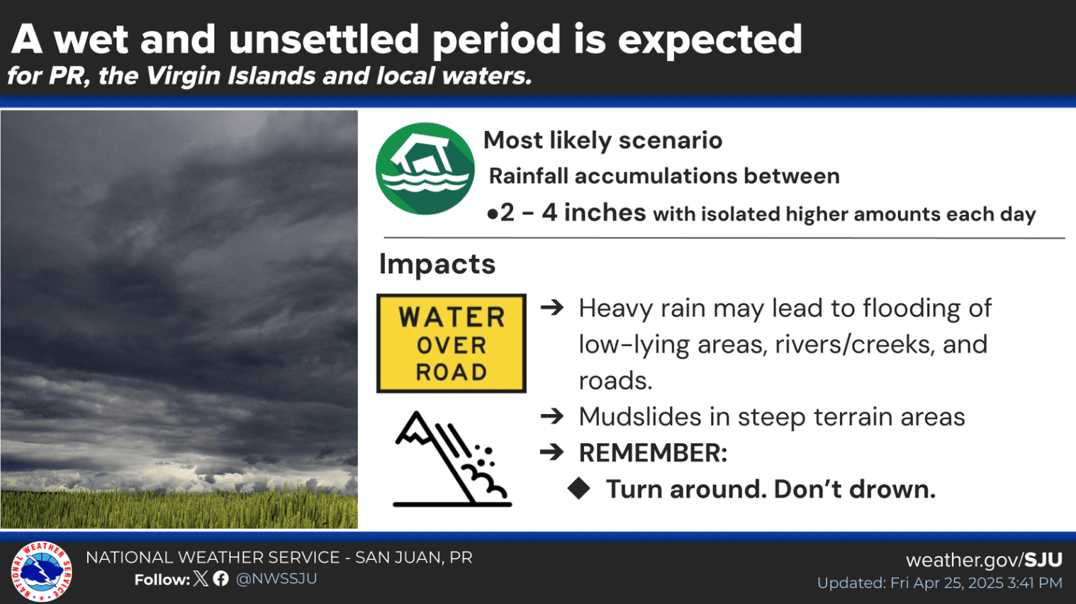
The National Weather Service expects unsettled weather across the U.S. Virgin Islands and Puerto Rico this weekend, with periods of showers and thunderstorms likely to continue into next week. With the St. Thomas Carnival set to take place from April 27 to May 3, individuals are encouraged to closely monitor the forecast.
“An increase in moisture, along with a series of troughs, will enhance the potential for showers and thunderstorms this weekend, and stretching into at least [next] Thursday,” according to an update on Friday from the NWS in San Juan, Puerto Rico.
Meteorologists at the National Weather Service said current atmospheric conditions will be conducive to the development of showers and thunderstorms in the coming days, with rainfall possibly heavy at times.
“In general, we are expecting [the potential for] rainfall accumulation of two to four inches each day [through next week], with the heaviest accumulation along the interior, north and western Puerto Rico,” the NWS warned. “However, periods of heavy rain will also reach the Virgin Islands and eastern Puerto Rico [as well],” the NWS said.
The Source contacted Lee Ann Inglés-Serrano, a meteorologist at the NWS in San Juan, who provided the following information about possible rainfall across the USVI.
“For the U.S. Virgin Islands, rainfall amounts are expected to be lower [than Puerto Rico], with the latest forecast indicating accumulations ranging from around one inch to up to two inches in areas where more intense showers develop,” Inglés-Serrano said.
Information from the NWS also noted the possibility of flooding, particularly between Sunday and Tuesday.
“The primary concern during this period is the increased risk of flooding, which is expected to remain elevated through at least midweek [next week],” the NWS explained. “Current [forecast] model trends indicate that the highest potential for moderate to heavy rainfall will occur between Sunday and Tuesday, which could lead to localized flooding, particularly in urban, low-lying, and mountainous areas,” the NWS stated.
“While there is still some uncertainty regarding the exact timing of the heaviest rainfall, the potential for impactful weather remains significant,” the NWS continued.
Marine Weather Update
The NWS also explained that there will be an elevated risk of rip currents due to an approaching northeasterly swell and an increase in winds.
“The [rip current] risk is expected to increase to high along north-exposed beaches by Saturday night into Sunday, as a northeasterly swell will start to spread across the Atlantic waters,” the NWS noted.
A previous Source article listed the following information about rip current safety from the NWS:
The most important factors to remember if caught in a rip current are:
- Relax. Rip currents don’t pull you under.
- A rip current is a natural treadmill that travels an average speed of one to two feet per second but has been measured as fast as eight feet per second — faster than an Olympic swimmer. Trying to swim against a rip current will only use up your energy — energy you need to survive and escape the rip current.
- Do NOT try to swim directly to shore. Swim along the shoreline until you escape the current’s pull. When free from the pull of the current, swim at an angle away from the current toward shore.
- If you feel you can’t reach the shore, relax, face the shore, and call or wave for help. Remember: If in doubt, don’t go out!
- If at all possible, only swim at beaches with lifeguards.
- If you choose to swim on beaches without a lifeguard, never swim alone. Take a friend who has a cellphone, so that person can call 911 for help.
Weather Forecast Information
Residents and visitors across the local islands are reminded that the 2025 Atlantic Hurricane Season begins on June 1 and lasts until November 30. Individuals can locate helpful hurricane season preparedness tips from the National Hurricane Center.
Weather forecast information and severe weather alerts are available from the Virgin Islands Territorial Emergency Management Agency’s website and the National Weather Service.
The Source Weather Page also publishes a daily weather forecast and allows readers to view weather forecast videos and disaster preparedness video segments.