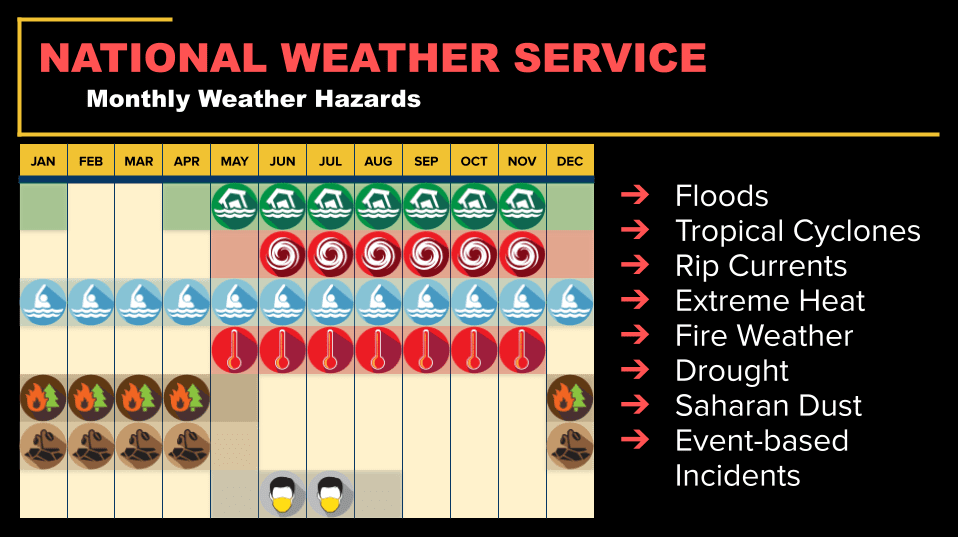
Hurricanes remain the most widely recognized weather threat in the U.S. Virgin Islands. However, forecasters say the territory faces significant hazards year-round, such as rip currents and hazardous surf, dry-season drought and fire-weather conditions, wet-season flooding downpours, and Saharan dust intrusions that can reduce visibility and impact air quality.
 That broader reality can sometimes surprise winter-season visitors and even some residents, who associate the months outside hurricane season with calm seas, steady trade winds, and mostly sunny skies. However, “winter” in the territory can still bring weather-related threats, including rough marine conditions, periods of wind and rain, and other hazards that can occur at any time of year, such as seismic activity.
Weather Hazards Don’t Stop When Hurricane Season Ends
The Source contacted the National Weather Service in San Juan, Puerto Rico, to better understand what meteorologists monitor most closely during the so-called off-season, including seasonal patterns, the risks that tend to impact residents and visitors this time of year, and how forecasting priorities shift as hurricane season approaches.
In comments provided to the Source, NWS meteorologist Carlos M. Anselmi-Molina emphasized that the territory’s weather risks extend well beyond the hurricane season, which encompasses the months between June and November. He noted that the NWS is always open each day and night around the clock, 365 days a year, keeping a watchful eye over severe weather.
“Although the Atlantic hurricane season runs from June 1 through Nov. 30, weather hazards affect the U.S. Virgin Islands year-round, which is why the Weather Forecast Office in San Juan operates 24 hours a day, seven days a week,” Anselmi-Molina stated.
Anselmi-Molina described the kinds of climate-related threats that affect the USVI throughout the year.
“The ‘dry season’ typically spans late November through April and sometimes until early May, when drought and elevated fire weather conditions can develop,” Anselmi-Molina explained. “April is generally a transition month into the ‘wet season,’ which runs from May through November and brings increased rainfall, localized flooding, extreme heat, and the peak of tropical cyclone activity,” he said.
“Saharan dust intrusions also occur and are most common from May through August, impacting air quality and visibility,” Anselmi-Molina added.
Hazardous Marine Conditions
Even when the weather feels pleasant on land, the ocean can tell a different story, especially when large storm systems in the North Atlantic send long-period swell energy into the Caribbean.
Anselmi-Molina explained that rip currents and powerful swells coming in from the Atlantic and Caribbean occur throughout the year, but these events are particularly concerning to forecasters between the months of October and March and sometimes beyond, depending on weather patterns.
“Rip currents are a persistent, year-round risk due to our exposure to Atlantic and Caribbean ocean swells,” Anselmi-Molina said. “During the winter months, particularly from late October through March, long-period northerly swells associated with North Atlantic storms and cold fronts frequently reach the region. These swells can generate hazardous marine conditions, life-threatening rip currents, dangerous breaking waves, and, at times, coastal flooding,” he noted.
A swell period refers to the time between breaking waves.
“These swells originate from strong low-pressure systems and Nor’easters over the North Atlantic during the winter season,” Anselmi-Molina said. “As cold fronts move off the U.S. East Coast, strong winds transfer energy to the ocean surface, generating long-period waves that propagate thousands of miles into the Caribbean. By the time these swells reach the U.S. Virgin Islands, they often produce hazardous marine and coastal conditions,” he emphasized.
For beachgoers, powerful swells can translate into conditions that look deceptively manageable from shore, until rip currents strengthen, surf builds, or wave sets become more powerful and frequent. For boaters, rougher seas can create higher risk, especially for small craft.
As the Source has reported this year throughout January and February, powerful swells and gusty winds have regularly affected the region.
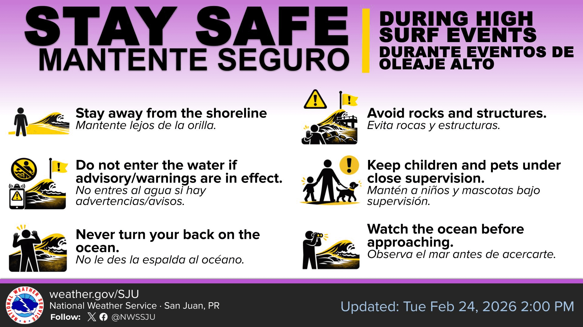
Swell events often require the NWS to issue marine alerts across Puerto Rico and the USVI to help protect boaters and swimmers. Marine warnings include alerts such as Small Craft Advisories, High Rip Current Statements, High Surf Advisories, and Coastal Flood Advisories.
“Dry Season” Doesn’t Mean “No Rain”
As Anselmi-Molina mentioned, the USVI and Puerto Rico have a dry season pattern, but winter can still bring wet stretches, and recent weeks have been an example of that variability.
“Regarding precipitation, preliminary January rainfall estimates across the U.S. Virgin Islands ranged from approximately two to four inches in St. Croix and near two inches in St. Thomas and St. John,” Anselmi reported.
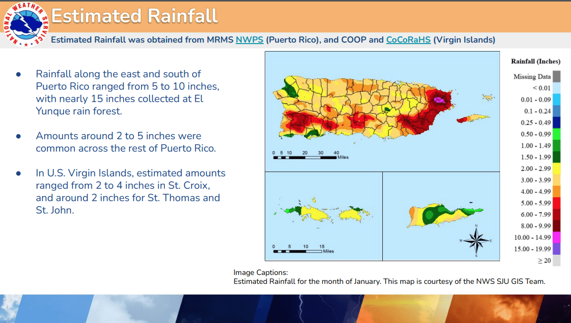
“When compared to the 1991-2020 climatology, several locations were near or slightly above their typical January averages. For February, although radar coverage limitations introduce some uncertainty in spatial totals, current estimates indicate that portions of the islands are trending wetter than normal relative to climatology,” he said.
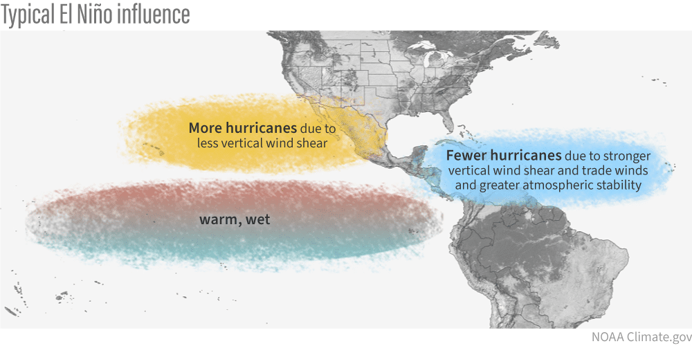
Anselmi-Molina added that larger climate signals can influence the overall weather pattern, even outside the wet season peak. These patterns can include the current cycle of the El Niño Southern Oscillation (ENSO), which encompasses El Niño, La Niña, and an ENSO-neutral phase.
“Currently, La Niña conditions are in place according to a recent Climate Prediction Center report, with a transition to ENSO-neutral expected in the coming months,” Anselmi-Molina explained. “While La Niña is more strongly associated with increased rainfall during the wet season across the northeastern Caribbean, it can also contribute to episodic increases in dry-season rainfall, which may be influencing recent precipitation patterns.”
For residents, that can mean anything from slick roads and localized flooding in heavy downpours to quick changes in wind and shower coverage that affect boating, beach plans, and day-to-day outdoor work.
AccuWeather Discusses Current Conditions and Upcoming Hurricane Season
To add more context and information to the details provided by the NWS, the Source also connected with Alex DaSilva, lead hurricane expert at AccuWeather, for additional insight into recent conditions and the climate signals forecasters are watching heading into summer and the hurricane season. The 2026 hurricane season is expected to coincide with a transition to an El Niño weather pattern.
The Source asked DaSilva about whether broader patterns may be playing a role in swell activity, rainfall variability, or wind trends.
“Looking at recent atmospheric patterns, the Bermuda High has been somewhat stronger recently, which likely explains at least part of the increased swell activity,” DaSilva acknowledged.
“A stronger Bermuda High increases the pressure gradient, which leads to stronger winds, and those winds can generate larger waves locally. Additionally, there have been several strong storms across the northern Atlantic, and swells from those systems have propagated southward, especially affecting northern-facing beaches. The recent increase in swell activity is likely a combination of a somewhat stronger Bermuda High, increased pressure gradient and winds, and swell energy propagating southward from large North Atlantic storms,” he continued.
In simple terms, some hazardous surf events are powered by storms far out in the Atlantic, while other episodes can be influenced by regional pressure patterns and stronger winds that help build seas closer to home.
Looking Ahead: From Late Winter to Hurricane Season Signals
While the main focuses during the winter months are often marine hazards, rainfall variability, thunderstorms with lightning, and changing wind conditions, forecasters are also beginning to watch the larger climate signals that could shape the upcoming hurricane season.
DaSilva discussed the current state of ENSO and how it may factor into forecasters’ early outlooks for the 2026 Atlantic hurricane season.
“We are transitioning out of a La Niña pattern and moving toward ENSO-neutral conditions,” DaSilva confirmed. “We currently expect El Niño to develop during the early to middle part of summer, which coincides with the early to middle portion of hurricane season. Typically, El Niño results in increased wind shear across the Atlantic basin — less favorable conditions for tropical cyclone development and below the historical average storm activity in many cases.”
DaSilva said AccuWeather is still refining its seasonal outlook, but that El Niño is one of several key signals being monitored as the season approaches.
“It is still too early to release official numbers regarding hurricane season. We are continuing to evaluate incoming data and teleconnections, including Atlantic Niño and other climate drivers. Meteorologists are fairly confident that El Niño will be present this summer, but we are still refining how other variables may influence the season. AccuWeather will release a full Atlantic Hurricane Seasonal Forecast in late March,” DaSilva declared.
Year-Round Risks Require Year-Round Awareness
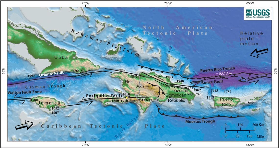
While hurricanes and marine hazards are among the most visible threats in the Virgin Islands, they are not the only ones that require ongoing preparedness. The region also experiences seismic activity and the potential for tsunami waves, underscoring the importance of year-round awareness for residents and visitors alike. The Source has previously reported on earthquake activity and preparedness in the region, and residents and visitors can read about earthquakes across the region in the Source’s prior coverage.
Stay Informed
Information about year-round weather safety can be located at Ready.gov. Local weather details, including marine weather conditions, is available from the NWS, the National Hurricane Center, and the National Oceanic and Atmospheric Administration.
Additionally, the local weather forecast for the U.S. Virgin Islands is regularly updated on the Source Weather Page. Residents and visitors can also find weather alerts and preparedness information from the Virgin Islands Territorial Emergency Management Agency.