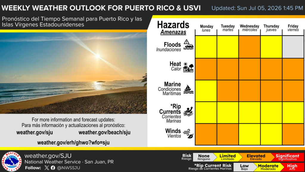
The National Weather Service in San Juan’s weekly weather outlook for Puerto Rico and the U.S. Virgin Islands shows heat, marine conditions, winds, and a midweek flood rainfall risk among the hazards to monitor. (Photo courtesy NWS San Juan, Puerto Rico)
A passing tropical wave may bring a brief chance of showers and thunderstorms to Puerto Rico and the U.S. Virgin Islands by midweek, though the wave is not expected to develop into a tropical system. Heat, Saharan dust, and breezy conditions are expected to remain the main weather concerns.
Tropical Wave Could Bring Brief Showers
The National Weather Service in San Juan, Puerto Rico, explained that a tropical wave could slightly increase moisture across the region around Wednesday and Thursday, bringing the possibility of showers and isolated thunderstorms.
Any precipitation across Puerto Rico and the USVI would help to alleviate dry conditions throughout both U.S. territories. However, the chance for rain is not guaranteed. The forecast does not currently point to a widespread rain event, as the bulk of moisture is forecast to remain south of the local islands. However, the NWS said the wave may still produce a few stronger showers where activity develops.
“A fast-moving tropical wave may bring a brief increase in showers and thunderstorms on Wednesday, with isolated lightning, locally heavy rainfall, and localized urban and small-stream flooding possible,” the NWS said on Monday. A chance of rain is also expected through Thursday morning.
“On Thursday, moisture associated with the northern periphery of a passing tropical wave will approach the region. Nonetheless, the bulk of the moisture from this wave is expected to remain well south of the area over the Caribbean Sea, keeping local impacts minimal,” the NWS stated.
Brief downpours, isolated thunderstorms with lightning, localized ponding in poor drainage areas, and minor flooding could occur if heavy showers reach the area.
Heat and Haze Remain Main Concerns
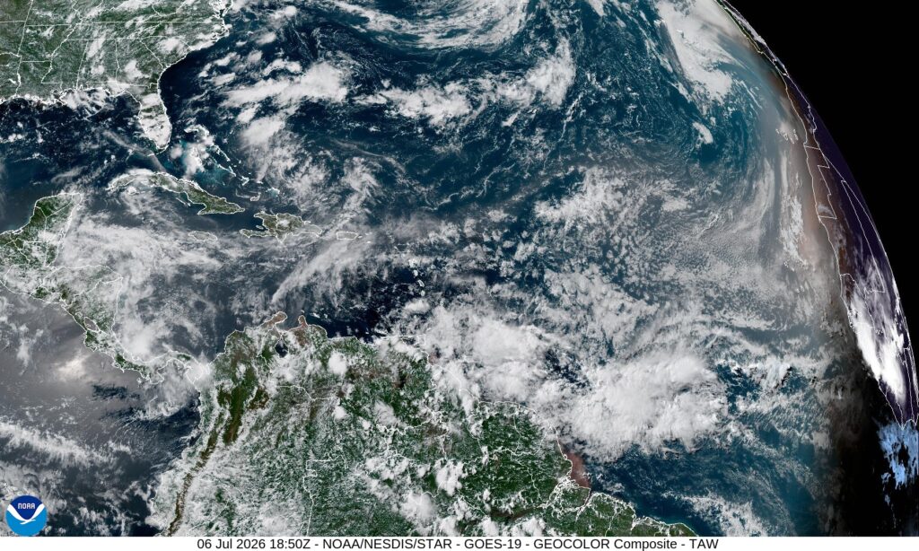
Caption: A NOAA satellite image shows clouds, moisture, and Saharan dust across the Atlantic basin, Caribbean and northern South America on July 6, 2026. (Photo courtesy NOAA/NESDIS/STAR)
The overall weather pattern will continue to favor hot, hazy, and breezy conditions through much of the week.
The NWS issued a heat advisory for areas across Puerto Rico and the USVI on Monday, as hot temperatures combined with increasing humidity produce a dangerously high heat index. Additional heat alerts may be issued across both U.S. territories as temperatures remain high.
“Similar conditions are expected Tuesday, with warm to hot conditions likely continuing through the remainder of the week,” the NWS forecast.
Saharan dust is also expected to remain a factor contributing to the heat. The NWS predicted that moderate to high concentrations of dust will produce hazy skies, reduced visibility, and poor air quality through Tuesday. An improvement in the hazy weather is possible Wednesday as a tropical wave passes, before dusty conditions return later this week.
The NWS said another plume of the desert sand may reach the region by the weekend, again creating hazy skies and degraded air quality.
“Sensitive groups, particularly those with respiratory issues or allergies, should take necessary precautions to limit outdoor exposure,” the NWS advised.
NOAA’s Climate Prediction Center also highlighted an ongoing risk of extreme heat across portions of the United States in its latest Hazards Outlook. Scientists say the broader warming trend is tied largely to human-caused greenhouse gas emissions. According to information from NASA, human-made emissions in the atmosphere trap heat and slow heat loss to space.
Breezy Winds, Choppy Seas Expected
Gusty winds, predominantly out of the east to east-southeast will continue across the local islands, creating choppy marine conditions and maintaining a moderate risk of rip currents at most beaches in Puerto Rico and the U.S. Virgin Islands.
The aforementioned approaching tropical wave could also increase showers and thunderstorms across regional waters by the middle of the week, possibly leading to locally hazardous marine conditions.
Beachgoers are encouraged to remain cautious, especially along beaches with a moderate rip current risk.
“Besides rip currents, beachgoers should remain weather alert, particularly for elevated heat risks and the arrival of a tropical wave that will increase shower and thunderstorm activity and may move near coastal areas of the islands on Wednesday,” the NWS stated.
Atlantic Basin Currently Remains Quiet
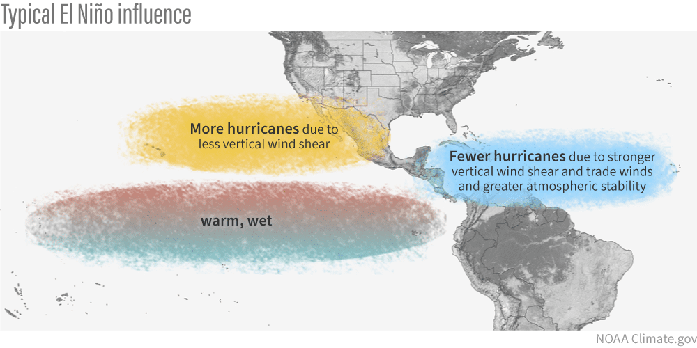
A NOAA Climate.gov graphic shows typical El Niño influence, including fewer Atlantic hurricanes due to stronger vertical wind shear, stronger trade winds, and greater atmospheric stability. (Photo courtesy NOAA Climate.gov)
Still, AccuWeather lead hurricane expert Alex DaSilva noted in a report released on Monday that wind shear is only one of the components that allow tropical storms and hurricanes to form.
“Very warm Atlantic sea-surface temperatures, especially along the United States, can allow tropical storms and hurricanes to develop and rapidly intensify much closer to the U.S. coastline,” DaSilva said in the AccuWeather article.
“As a result, residents may have significantly less time to prepare than they would if storms formed near Africa and tracked across the Atlantic,” warns DaSilva.
He added, “It will be especially important to closely monitor every tropical wave this season. Some tropical waves may remain disorganized while crossing the Atlantic, only to develop and intensify once they reach the exceptionally warm waters near the United States,” DaSilva explained.
Pacific U.S. Territories Face Another Major Typhoon
While the Atlantic remains quiet for now, U.S. territories in the western Pacific have been dealing with a powerful tropical cyclone.
As the Source previously reported, Super Typhoon Sinlaku caused major damage and a long recovery across areas of the same islands only months ago. Pacific U.S. territories experience many of the same challenges as the territories in the Caribbean, including significant delays in repair of infrastructure after a major storm.
NOAA’s 2026 Western North Pacific Tropical Cyclone Outlook, released in June, warned that Guam and the CNMI would likely see above-normal tropical cyclone activity for the remainder of the year. NOAA said the expected increase was consistent with an anticipated shift toward El Niño, which can move tropical cyclone development eastward and allow some systems more time to intensify before affecting the Marianas and western Micronesia.
Local Updates
Currently, there are no immediate tropical cyclone threats to Puerto Rico or the U.S. Virgin Islands. Residents are encouraged to follow the local forecasts, as Saharan dust, gusty winds, and a chance of rain remain part of the weather forecast this week.
Information regarding the weather across the USVI can be obtained from the NWS, the NHC, and NOAA. Additionally, the local forecast is regularly updated on the Source Weather Page, and a weekly video forecast is available. Residents and visitors can view weather alerts and disaster preparedness information from VITEMA.