On Wednesday, AccuWeather released its 2026 Atlantic hurricane season forecast, calling for a near- to below-historical average season overall. However, forecasters warned that damaging impacts remain possible throughout the season, which officially runs from June 1 to Nov. 30.
AccuWeather’s Outlook
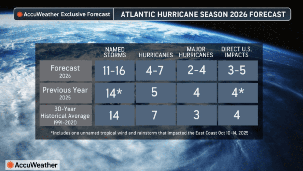
The AccuWeather tropical forecast for the Atlantic hurricane season predicts 11 to 16 named storms, including four to seven hurricanes and two to four major hurricanes of at least Category 3 intensity. AccuWeather is also forecasting three to five direct impacts in the United States this season. The National Hurricane Center notes that the historical 30-year average for the Atlantic hurricane season is 14 named storms, seven hurricanes, and three major hurricanes.
AccuWeather said that while the season could end up near or slightly below average overall, a potentially lower number of cyclones does not necessarily mean a lower risk of severe weather outcomes. The company identified the northern and northeastern Gulf Coast and the Carolinas as the U.S. areas at greatest risk for direct impacts this year.
“It’s very important that everybody from South Texas all the way to Maine prepares equally for each and every hurricane season, regardless of what the official forecast is,” said Alex DaSilva, AccuWeather lead hurricane expert, in Wednesday’s report. “Even if it’s expected to be a slightly below-average hurricane season, we can still see major hits across the United States,” DaSilva warned.
El Niño Remains a Key Part of the Setup
A major reason AccuWeather expects a somewhat less active season overall is the anticipated development of an El Niño weather pattern this year.
“Scientists call the two opposing climate patterns of El Niño and La Nina the ‛El Niño-Southern Oscillation’ (ENSO) cycle. El Niño and La Nina can both have global impacts on weather, wildfires, ecosystems, and economies,” according to the National Oceanic and Atmospheric Administration (NOAA). ENSO-neutral typically occurs in between phases of à la Niña or an El Niño event.
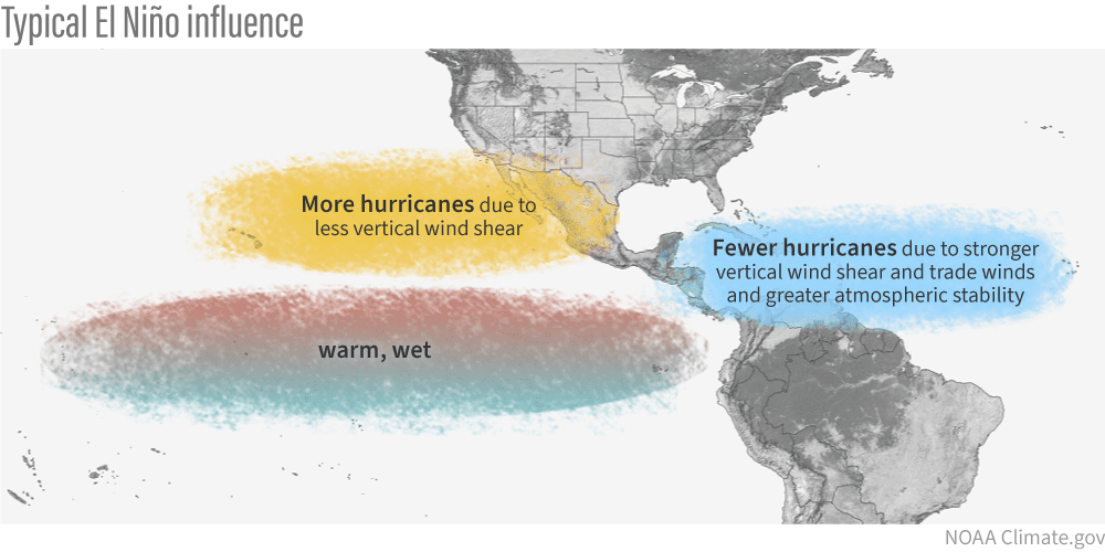
El Niño, which involves a warming of the equatorial Pacific Ocean, usually helps to increase wind shear — a change in wind direction and velocity with height in the atmosphere — in the Atlantic Ocean, helping to rip apart storms and prevent hurricane formation and intensification. This is the opposite of à la Niña cycle, when the ocean waters across the equatorial Pacific cool significantly. During La Nina, wind shear typically decreases in the Atlantic, and a reduction in wind shear can favor cyclone development.
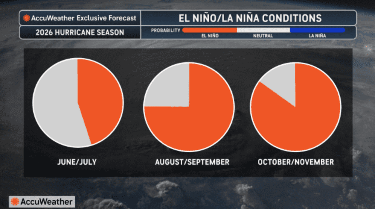
In its forecast, AccuWeather said El Niño could help suppress Atlantic activity, especially during the second half of the season, and noted about a 15% chance of a very strong “super El Niño” later in the year.
“There is about a 15% chance that a ‘super El Niño’ will develop if ocean temperatures near the equator of the eastern Pacific rise at least 2 degrees Celsius (3.6 degrees Fahrenheit) above long-term averages. If it does happen, it could sharply reduce storm activity in late October and November,” AccuWeather explained.
“The last time there was an El Niño during the Atlantic hurricane season was 2023, which was busier than normal with 20 named storms, above the historical average of 14. What made 2023 very special is it was also the warmest year on record, if we take a look at the average sea surface temperatures across the Atlantic basin,” DaSilva stated. “Waters across the Atlantic are expected to be warm throughout 2026, though not as high as in 2023,” AccuWeather noted.
Indeed, NOAA’s recent ENSO outlook, released on March 12, said that La Nina is expected to transition to ENSO-neutral in the near term, with El Niño likely to emerge in June-August 2026 and persist through at least the end of the year.
Additional Factors Influencing Tropical Development
Even with El Niño expected to work against storm development, AccuWeather meteorologists reported that ocean water temperatures across the Atlantic basin are still expected to remain unusually warm, which could help cyclones rapidly intensify.
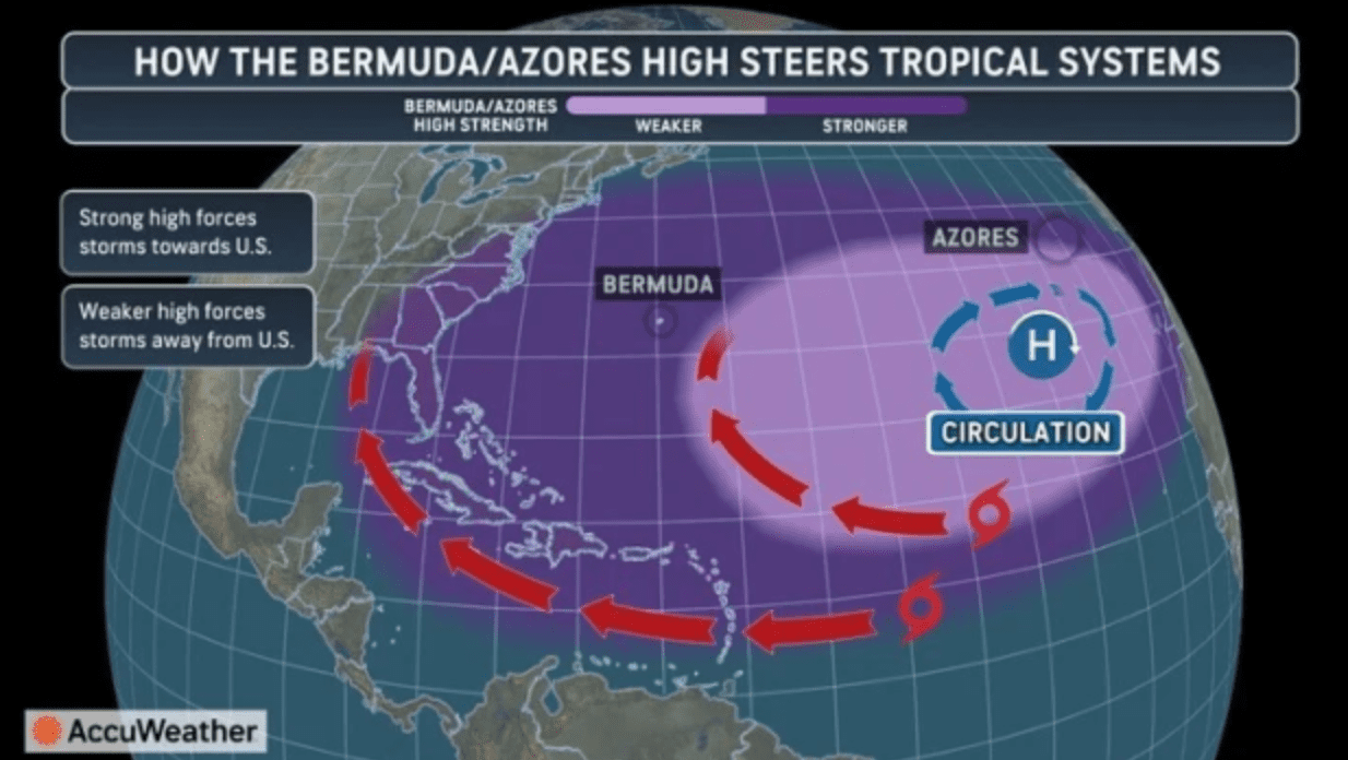
Additionally, AccuWeather forecasters noted that the location of the Bermuda-Azores High Pressure over the Atlantic, as well as the amount of Saharan dust that travels across the Main Development Region between West Africa and the Caribbean, will contribute to the development potential of tropical cyclones.
The Source contacted DaSilva to learn more about possible impacts across the northeastern Caribbean, including Puerto Rico and the U.S. Virgin Islands. DaSilva said he is concerned about an above-average risk of impacts in the northeastern Caribbean this season.
“I believe that the Bermuda-Azores High is going to be in a very similar spot to what we saw in 2025, located farther to the east in the Atlantic,” DaSilva said. “Some of the storm tracks could be very similar to what we saw last year, where we saw recurves away from the islands. However, I am concerned about the northeastern Caribbean, including Puerto Rico, the Virgin Islands, and the northern portion of the Lesser Antilles, where there may be an above-average risk of impacts this season,” he cautioned.
Hurricane Erin, a powerful Category 5 storm that passed just north of the U.S. Virgin Islands last August, is one example of the kind of close call DaSilva is focused on this season.
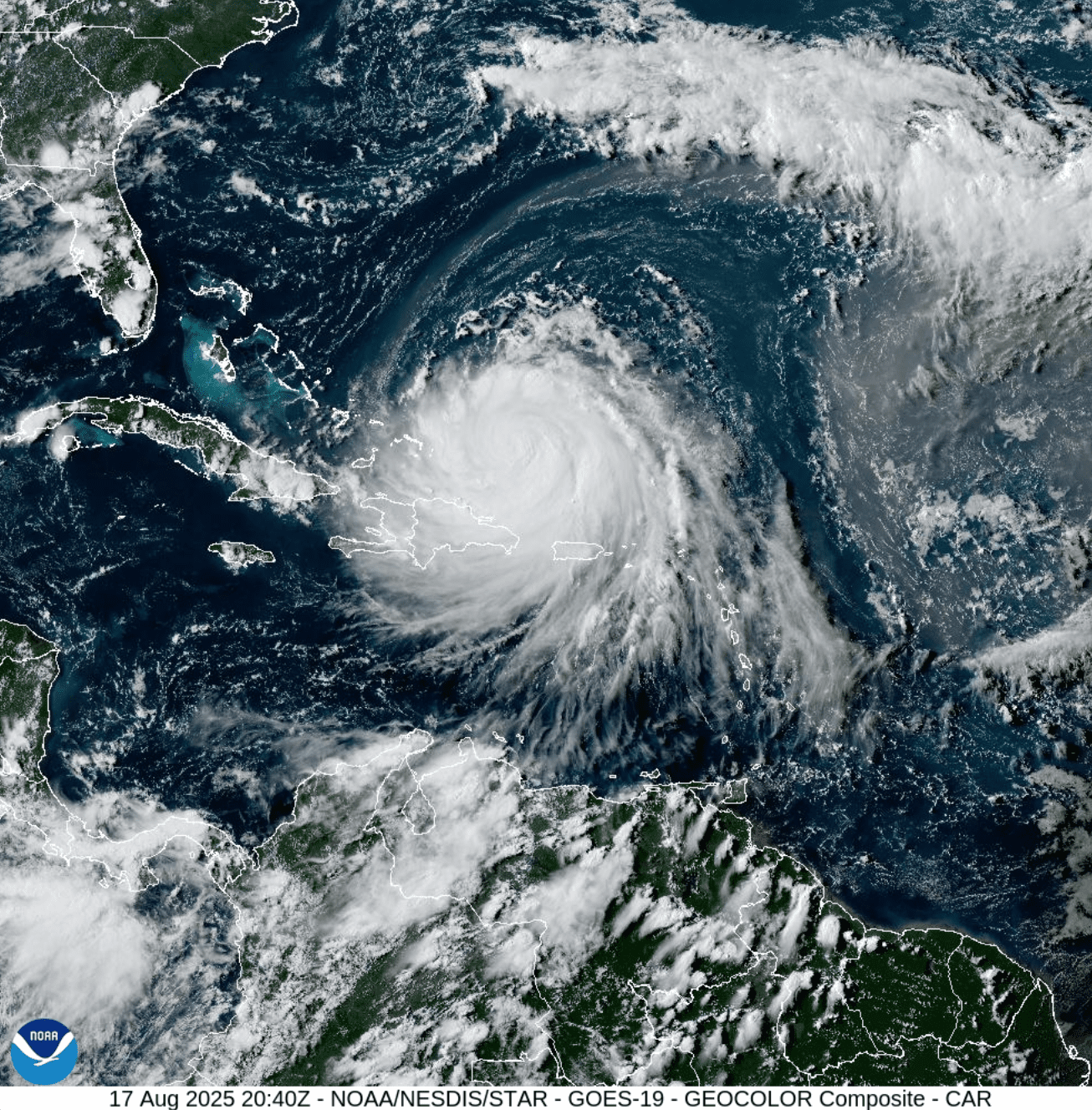
“Last year, you saw a couple of very close calls in the northeastern Caribbean,” DaSilva said. “Most of the major storms passed to your north, but it was close, and it wouldn’t have taken much to have those storms a little bit farther to the south. Relative to the historical average, I would say the northeastern Caribbean has an above-average risk of impacts this upcoming season. Once you get farther south, towards Barbados and the southern portion of the Lesser Antilles, the risk is much lower, because of the general steering pattern.”
“We’ll have to keep an eye on El Niño. The stronger it gets, the more wind shear there’s likely to be in the Atlantic, which would be good news for the northeastern Caribbean,” DaSilva added.
Ocean Water Temperature and Rapid Intensification
DaSilva also shared concerns about warm ocean temperatures that could help hurricanes undergo rapid intensification.
“Near the northeastern Caribbean, the waters are going to be very warm,” DaSilva confirmed. “Similar to what we saw last year with a couple of Category 5 hurricanes just north of the islands, the risk is going to be there again for some hurricanes that could pass very close. We’re going to have to monitor that extremely closely. I am very concerned about rapid intensification once again this year,” he warned.
AccuWeather’s hurricane season outlook said that because of the warm ocean water temperatures, there is even a chance that tropical systems could organize even before hurricane season begins. However, DaSilva said that if any early development occurs, it would most likely “be confined to the Western Caribbean, the Gulf, and off the southeast coast of the United States,” rather than near the U.S. Virgin Islands.
“Forecasters are also keeping a close eye on the weeks before and just after the official start of the Atlantic hurricane season on June 1,” the AccuWeather report said. “With warm waters firmly in place in the areas where storms typically develop early in the season, it may not take much to have tropical activity fire up around the same time that the season officially gets underway,” the report continued.
Be Prepared
For the U.S. Virgin Islands and Puerto Rico, seasonal forecasts help describe the broader setup heading into hurricane season, but they do not predict whether any one island will be affected. It only takes one storm near the region to bring serious impacts. That may be especially true in a season like this one, when the final storm count could end up near or slightly below average, but the environment may still support dangerous storms.
Additional seasonal outlooks are expected in the coming weeks and months, and forecasters will continue monitoring El Niño development, ocean temperatures, and steering patterns as the season approaches.
Finally, NOAA also announced a forecasting change for 2026. The NHC’s updated cone graphics will now include inland tropical storm and hurricane watches and warnings, including for Puerto Rico and the U.S. Virgin Islands, and an experimental cone graphic is also planned. Details can be found in a recent news article on NOAA’s official website.
Local Weather Information
The Atlantic hurricane season runs from June 1 through Nov. 30, but severe weather preparedness is a year-round practice in the Virgin Islands. Residents can follow NOAA’s Climate Prediction Center for ENSO updates, and the local weather forecast for the U.S. Virgin Islands is regularly updated on the Source Weather Page. Individuals can also find helpful weather information, emergency preparedness, and alerts from the Virgin Islands Territorial Emergency Management Agency.