AccuWeather meteorologists are forecasting a “near to above average” Atlantic hurricane season for this year, according to a report released by the organization Friday. Ahead of this year’s hurricane season, residents across the Virgin Islands are urged to be prepared and stay informed about potential threats.
The AccuWeather report provided the following information regarding the possible number of storms that could form during the season, which runs from June 1 until November 30.
“AccuWeather is forecasting near to above the historical average number of named storms, hurricanes, major hurricanes, accumulated cyclone energy, and direct impacts to the United States,” according to a comment in the article from Alex DaSilva, AccuWeather’s lead hurricane expert.
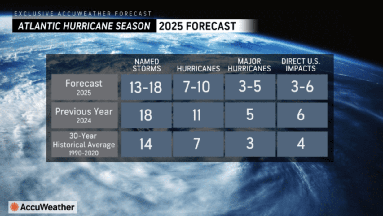
“Between 13 and 18 named storms are expected in 2025, including seven [to] 10 hurricanes, three to five major hurricanes that reach Category 3 strength or higher, and three to six direct U.S. impacts,” DaSilva said. “DaSilva added that there is a 20 percent chance of more than 18 named storms this year,” the report stated.
The AccuWeather report outlined several factors behind the forecast, including anomalously warm ocean water temperatures across the Atlantic Ocean, the position of the Bermuda-Azores High (a semi-permanent area of high pressure over the Atlantic that influences the steering of cyclones), and the number of possible tropical waves that emerge off the west coast of Africa.
El Niño -Southern Oscillation
Additionally, the AccuWeather update explained how the El Niño-Southern Oscillation [ENSO] cycles, which include La Niña, El Niño, and a neutral transition phase, can influence tropical development.
A previous Source article explained that, during a La Niña cycle, the ocean waters across the equatorial Pacific Ocean cool significantly, affecting global weather. During La Niña, wind shear—a change in wind direction and velocity with height in the atmosphere—also typically decreases in the Atlantic Ocean. A reduction in wind shear can favor cyclone development. This pattern is the opposite of El Niño, a warming of the equatorial Pacific, which usually increases wind shear in the Atlantic Ocean, helping to rip apart storms and prevent hurricane formation and intensification.
“Scientists call [the two opposing climate patterns of El Niño and La Niña] the ‘El Niño-Southern Oscillation’ cycle. El Niño and La Niña can both have global impacts on weather, wildfires, ecosystems, and economies,” according to NOAA.
A neutral phase of ENSO occurs when neither El Niño nor La Niña are happening, and AccuWeather noted that this phase may occur during at least part of this year’s hurricane season.

“ENSO-neutral refers to periods when neither El Niño nor La Niña is present,” according to information from the National Weather Service. “These periods often coincide with the transition between El Niño and La Niña events. During ENSO-neutral periods the ocean temperatures, tropical rainfall patterns, and atmospheric winds over the equatorial Pacific Ocean are near the long-term average,” the NWS explained.
A Tropical Expert’s Thoughts
The Source contacted Alex DaSilva for more details about the AccuWeather predictions for the season, including how the U.S. Virgin Islands may be affected this year.
DaSilva explained the phases of ENSO, including how an ENSO-neutral phase could still result in favorable conditions for cyclonic development.
“La Niña conditions [which are currently occurring] may still linger in the early part of the tropical season; however, a transition to ENSO-neutral by summer is expected,” DaSilva explained. “The neutral phase ENSO is then forecast to continue through most of the hurricane season,” he continued.
“While La Niña typically yields a more active hurricane season in the Atlantic Ocean due to less frequent vertical wind shear, the neutral phase of ENSO can also contribute to an active season [but] to a lesser extent,” DaSilva cautioned. “Research has found that La Niña and neutral years are usually very close in the number of storms [that each phase can] produce, with La Niña years typically producing the most [cyclones],” DaSilva stated.
“At this point, we are leaning toward either ENSO remaining neutral for a majority of the season or a weak La Niña to form in the late summer or fall.,” DaSilva said. “A [transition into] an El Niño this hurricane season seems unlikely,” he continued.
Factors Influencing Tropical Development
DaSilva also explained that a La Niña weather pattern, which can have similar effects as a neutral pattern, can influence the number of tropical waves moving off the west coast of Africa. He provided the following information about how this can occur:
“La Niñas typically support a stronger African Easterly Jet [a weather feature that can generate strong easterly winds]. A stronger African Easterly Jet would support a stronger African monsoon, and therefore, the potential for more robust tropical waves moving off the continent of Africa that can develop into tropical storms or hurricanes in the Atlantic. A neutral [ENSO] pattern, which we expect to [occur] for the majority of the season, typically supports a moderately strong jet. [However,] it is important to note that a jet that is [extremely] strong could support more episodes of dry air moving off the African continent.”
DaSilva explained how sea surface temperatures and the Bermuda-Azores High can affect the formation and intensification of hurricanes.
“Sea surface temperatures are currently well above the historical average across much of the Atlantic basin, especially in the Gulf and Caribbean. Sea surface temperatures across the Main Development Region Atlantic [an area between western Africa and the Lesser Antilles where cyclones often form] are near to above average. There is high confidence that sea surface temperatures across most of the Atlantic basin will remain well above the historical average for the duration of the hurricane season,” DaSilva said.
“Above-average sea surface temperatures typically support more frequent periods of lower surface pressure during the season, [and] this can lead to more tropical development over the course of the season. The ‘ocean heat content,’ or the depth of the very warm water across the Atlantic, especially in the western Caribbean and the Gulf, is forecast to be very high during the season. Deep warm water can help to promote the rapid intensification of tropical cyclones.
“The Bermuda-Azores High also influences the tropical season,” DaSilva continued. “The high [pressure system] can grow and shrink throughout the season and can determine if storms move out to sea or are pushed into the Caribbean. The [position of the] Bermuda-Azores High can be offset farther south and east compared to average due to high sea surface temperatures. [The location where the high pressure is situated] can favor a period of re-curving tropical systems in the western Atlantic when the high [pressure] is weaker and another period of storms reaching the Caribbean and Gulf when the high [pressure] is stronger.”
DaSilva added that the “[ongoing and] lingering La Niña conditions combined with very warm sea surface temperatures this spring may help to promote an increased chance of early season development [possibly around] May or June close to the United States.”
Creation of the Forecast and Possible Impacts to the USVI
DaSilva said that AccuWeather meteorologists analyzed previous years that followed a similar pattern predicted for this year’s hurricane season. Intriguingly, he noted that 2025 appears to contain similarities to the 2017 Atlantic hurricane season, during which the devasting storms, including Hurricanes Irma and Maria, developed.
DaSilva explained, “[AccuWeather forecasters] looked back at 12 years that had similar atmospheric conditions to what we expect this year. These analog years were 1965, 1967, 1984, 1986, 1996, 2001, 2006, 2009, 2012, 2014, 2017 and 2023. This is one of the main things we look at when creating the forecast. Each year has slightly different analog years, and we use these to help us predict which areas might be more vulnerable for impacts in the upcoming year. All the years listed above had similar patterns to what we expect this year.
“While many tropical storms and hurricanes impacted the islands during these years, one year really stands out, and that was 2017,” DaSilva said. “2017 featured [hurricanes such as] Maria and Irma and had very similar patterns in a neutral ENSO pattern for most of the season. This is one of the reasons why we think that the northeast Caribbean has an increased chance of tropical impacts this season. Analog years don’t guarantee that a storm will make landfall in the upcoming year, but they can give us an idea about which areas could be at an increased risk,” he stated.
“It is important that residents don’t become complacent if a hurricane has not impacted their area in several years,” DaSilva warned. “All residents and interests in Puerto Rico and the Virgin Islands should have a hurricane plan in place and always be fully prepared for a direct impact every hurricane season. It’s also important to note that rip-current risks along the beaches can be very high even if a storm is located hundreds of miles away. Some evacuation centers and recovery procedures could still be different than in pre-pandemic years. We urge all residents to check with their local emergency management government officials for changes.”
Weather Forecast Information
Additional hurricane season forecasts will become available in the weeks leading up to June 1, the start of hurricane season. However, tropical development can occur outside of the official start to the season, and individuals are encouraged to remain vigilant.
Weather forecast information, including severe weather alerts, is available from the VITEMA website and the National Weather Service.
Finally, the Source Weather Page publishes a daily weather forecast and offers readers the opportunity to view weather forecast videos.