Colorado State University has lowered its forecast numbers for the 2026 Atlantic hurricane season, now calling for slightly fewer named storms and hurricanes, as confidence grows that a potentially strong El Niño could help suppress activity across the Atlantic basin.
CSU’s June Update
In its latest extended-range forecast issued Wednesday, the Tropical Cyclones, Radar, Atmospheric Modeling, and Software Team at CSU predicted 11 named storms, including five hurricanes and two major hurricanes of Category 3 strength or higher.
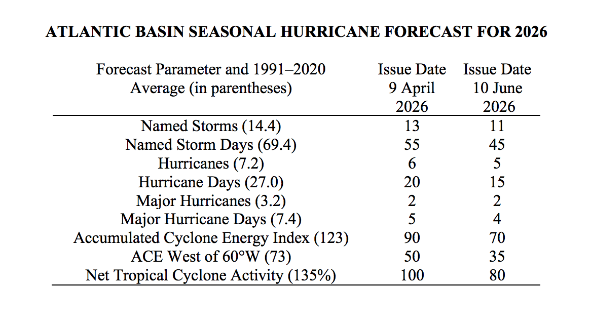
That is lower than the university’s initial tropical forecast released in April, which called for 13 named storms, including six hurricanes and two major hurricanes. As the Source previously reported, CSU’s first outlook of the year already pointed toward a somewhat below-average season, with El Niño expected to play a major role in limiting Atlantic tropical activity.
In its June update, CSU explained the reduction in anticipated tropical cyclones.
“We have reduced our 2026 Atlantic basin hurricane season forecast and anticipate a below-normal season,” CSU said. “Warm neutral-ENSO conditions are likely to transition to El Niño shortly, with a high potential for a moderate to strong El Niño for the peak of hurricane season.”
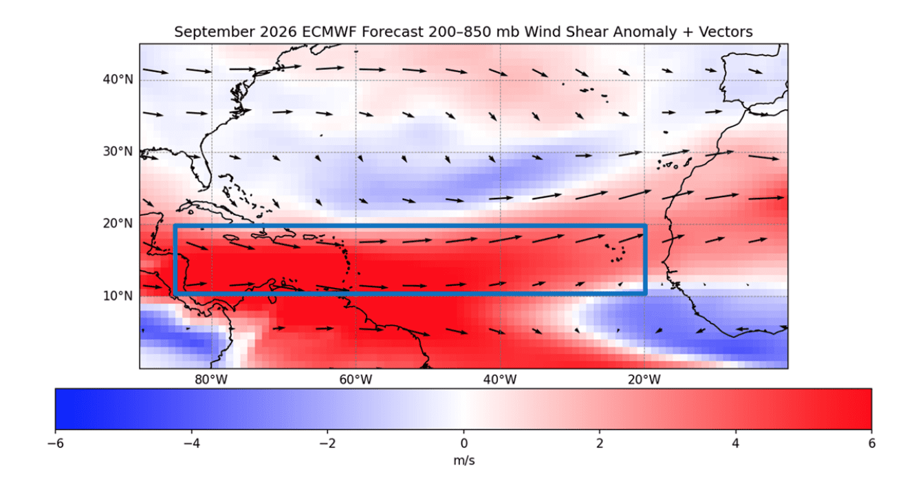
“We anticipate El Niño being the dominant factor for the upcoming hurricane season, driving increased levels of tropical Atlantic vertical wind shear. We are forecasting a below-average probability for major hurricane landfalls along the continental United States coastline and in the Caribbean,” CSU stated.
CSU also said that the updated forecast is below the 1991-2020 seasonal average of 14.4 named storms, 7.2 hurricanes and 3.2 major hurricanes. The group also reduced its forecast for Accumulated Cyclone Energy, from 90 in April to 70 in the June update. ACE is a metric used to measure the overall energy produced by tropical storms and hurricanes during a season.
Factors Contributing to the Reduced Forecast
CSU’s report explained that the reduction in cyclone numbers is largely tied to increasing confidence that a moderate to strong El Niño will develop during the peak of the Atlantic hurricane season.
“All signs point towards a robust El Niño,” CSU stated in its report.
According to the National Oceanic and Atmospheric Administration, “Scientists call the two opposing climate patterns of El Niño and La Niña the ‛El Niño-Southern Oscillation’ cycle. El Niño and La Niña can both have global impacts on weather, wildfires, ecosystems, and economies.” An ENSO-neutral phase typically occurs between phases of La Niña and El Niño events.
El Niño, which involves a warming of the equatorial Pacific Ocean, usually helps to increase wind shear – a change in wind direction and velocity with height in the atmosphere. In the Atlantic Ocean, the increase in wind shear from El Niño helps to rip apart storms and prevent hurricane formation and intensification. This is the opposite of a La Niña cycle, when the ocean waters across the equatorial Pacific cool significantly. During La Niña, wind shear typically decreases in the Atlantic, and a reduction in wind shear can favor cyclone development.
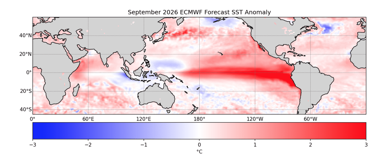
Wind shear is only one factor that contributes to cyclonic development, and CSU noted that sea surface temperatures will also play a role in how active the tropics become.
“Sea surface temperatures in the western tropical Atlantic are near average but are cooler than normal in the eastern and central tropical Atlantic,” CSU explained.
Indeed, the latest update from NOAA’s Climate Prediction Center continues to support the idea that El Niño will play a significant role during the 2026 Atlantic hurricane season.
In its May 14 ENSO Diagnostic Discussion, CPC maintained an El Niño Watch and stated, “El Niño is likely to emerge soon, with an 82% chance in May-July 2026, and continue through Northern Hemisphere winter 2026-27, with a 96% chance in December 2026-February 2027.” While NOAA noted that “ENSO-neutral conditions continued,” the agency also said that confidence in El Niño has increased since last month, although there remains “substantial uncertainty in the peak strength of El Niño.”
What This Means for the Caribbean
While CSU’s updated forecast suggests a quieter overall season, forecasters continue to stress that seasonal numbers do not determine whether any one island or coastline will be affected.
In the June update, CSU placed the probability of at least one major hurricane tracking through the Caribbean region at 26%, below the long-period average of 47%. That is also lower than the 35% probability included in CSU’s April forecast.
For the entire continental U.S. coastline, CSU placed the probability of at least one major hurricane landfall at 24%, compared with the long-period average of 43%. The U.S. East Coast, including the Florida Peninsula, was given an 11% probability, while the Gulf Coast was given a 14% probability.
NOAA Also Calls for a Below-Normal Season
The updated CSU outlook is generally in line with NOAA’s official 2026 Atlantic hurricane season forecast, which was released in May. As the Source previously reported, NOAA’s hurricane season outlook calls for eight to 14 named storms, including three to six hurricanes and one to three major hurricanes of Category 3 strength or higher. NOAA said there is a 55% chance of a below-normal season, a 35% chance of a near-normal season and a 10% chance of an above-normal season.
NOAA also noted that El Niño is expected to develop and intensify during the hurricane season, although forecasters emphasized that there is still uncertainty in exactly how the season will unfold.
Additionally, the Source reported that AccuWeather predicted 11 to 16 named storms, including four to seven hurricanes and two to four major hurricanes, also below the climatological average.
The Atlantic hurricane season runs from June 1 through Nov. 30, and the historical peak of the season typically occurs from mid-August through October. There are currently no tropical cyclone threats to the U.S. Virgin Islands.
However, as of the National Hurricane Center’s 1 p.m. AST Wednesday Tropical Weather Outlook, the agency was monitoring the Bay of Campeche, where an area of low pressure could form late this week. However, significant development was not expected, and the system is forecast to move inland over eastern Mexico late this weekend. The NHC placed formation chances at near zero through 48 hours and 10% over the next seven days.
Even with the lower forecast, CSU reminded residents that a single hurricane can make a season dangerous for those in the path of a storm, and that preparations should be made every season regardless of the predicted level of activity.
Following the Weather
CSU plans to release additional tropical forecasts over the coming months, and the next update from the university is scheduled for publication on July 8. Residents can follow CSU’s updates on the organization’s official website and visit NOAA’s Climate Prediction Center for ENSO updates
Additionally, the local weather forecast for the U.S. Virgin Islands is regularly updated on the Source Weather Page, and the Source will also release periodic Tropical Outlooks throughout hurricane season. Individuals can also find helpful weather information, emergency preparedness details and alerts from the Virgin Islands Territorial Emergency Management Agency.