A Heat Advisory will be in effect across the U.S. Virgin Islands and Puerto Rico on Thursday as hot weather affects the region. Additionally, marine conditions will be choppy and passing showers are possible, according to the National Weather Service in San Juan.
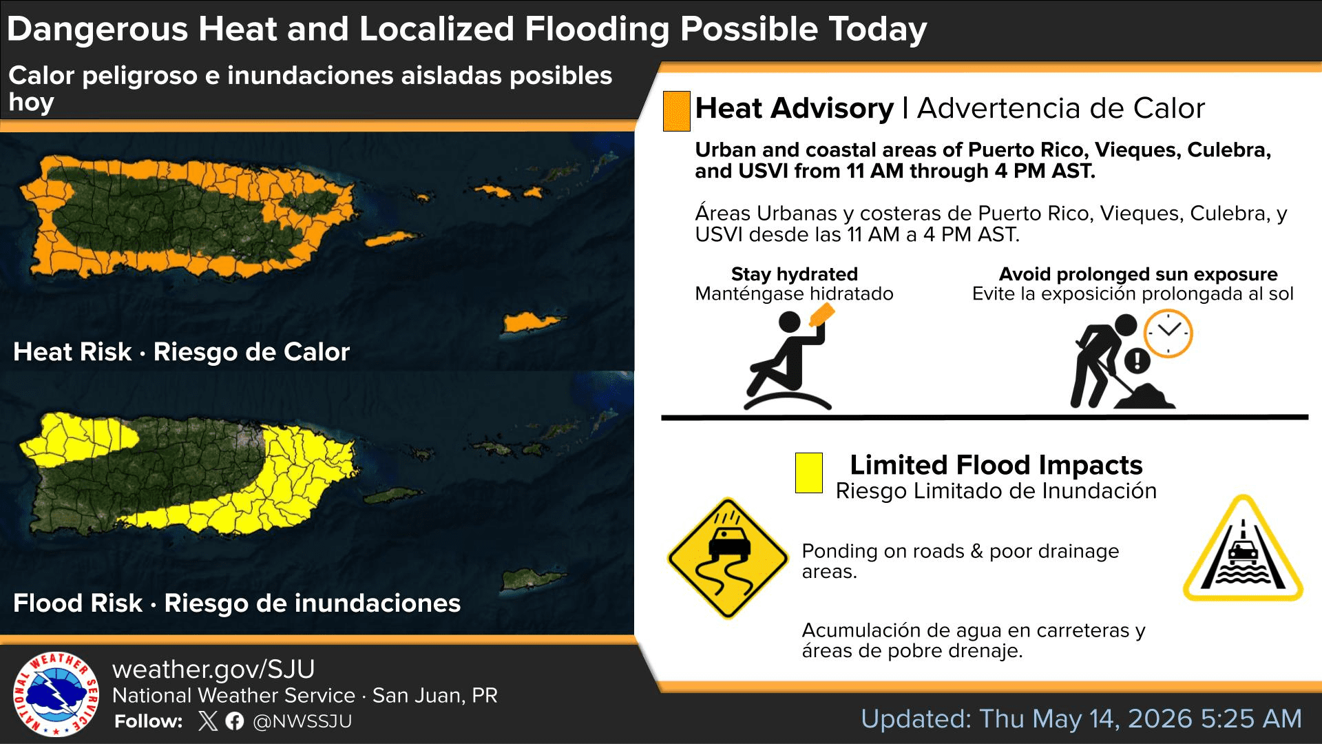
Heat Advisory Issued
The Heat Advisory, issued by the NWS, will be in effect from 11 a.m. to 4 p.m. AST Thursday for the U.S. Virgin Islands and portions of Puerto Rico, according to an update from the NWS on Thursday morning. The excessive heat is expected to continue over the coming days, and additional heat alerts could be issued.
“Dangerous heat conditions will continue through the weekend across urban and coastal areas of Puerto Rico and the U.S. Virgin Islands, with heat indices exceeding 100°F at times. Additional Heat Advisories may be required,” the NWS said.
“Heat indices are expected to reach values up to 111°F in urban and coastal areas,” the NWS added.
The NWS explained that a Heat Advisory “means that temperatures of at least 100°F or heat index values of at least 105°F are expected generally within the next 24 hours.”
The NWS defines the heat index, also known as the apparent temperature, as “what the temperature feels like to the human body when relative humidity is combined with the air temperature.”
Residents and visitors are encouraged to stay hydrated, limit strenuous outdoor activity during the hottest part of the day, and check on vulnerable individuals, including children, older adults, outdoor workers, pets, and people without access to adequate cooling.
“These conditions can be dangerous, particularly for people sensitive to heat, those without adequate hydration or cooling, outdoor workers, and vulnerable populations,” the NWS warned. “Heat stress may also impact some healthcare systems and heat-sensitive industries.”
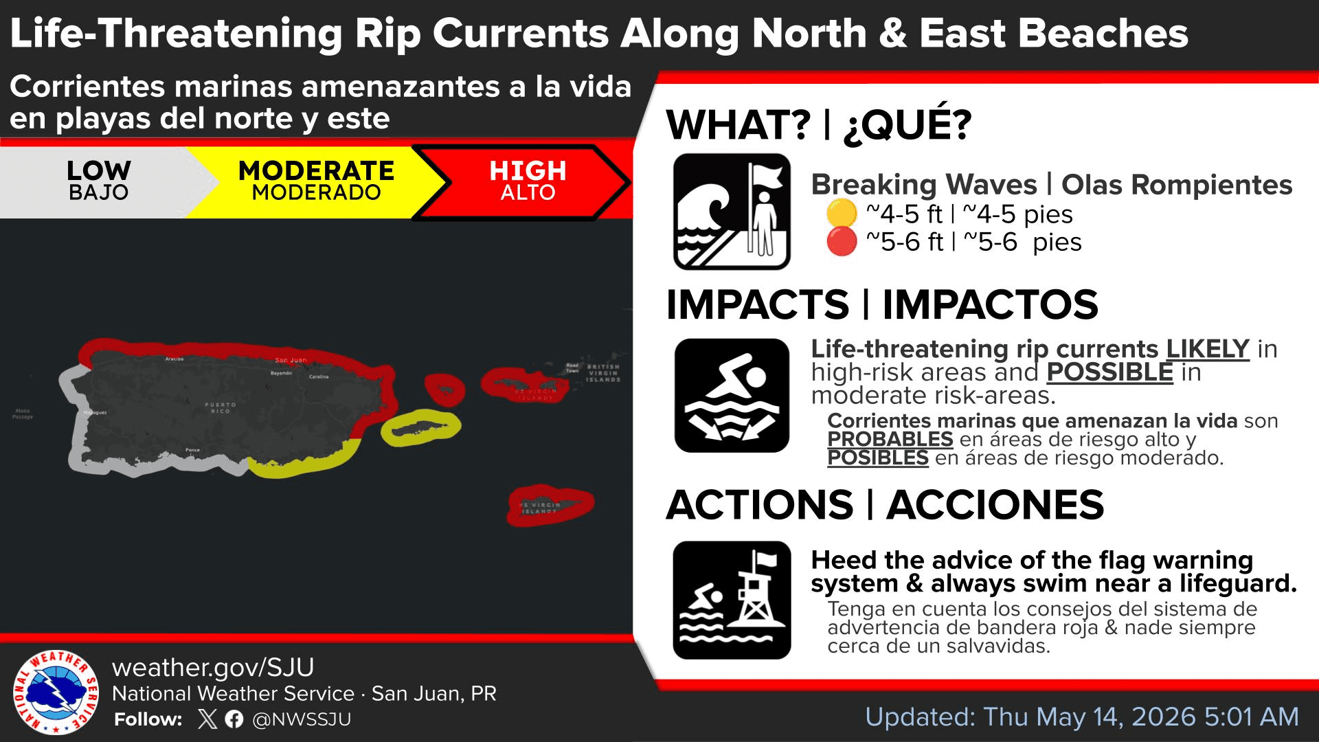
north- and east-facing beaches in Puerto Rico and the U.S. Virgin Islands. (Photo courtesy NWS, San Juan, Puerto Rico)
Marine Conditions
Marine conditions will remain somewhat choppy due to breezy east to east-southeasterly winds across the regional waters. A high risk of rip currents is in effect for the U.S. Virgin Islands until 6 a.m. on Friday.
“A northeasterly swell combined with locally generated wind waves will maintain a high risk of dangerous rip currents along portions of the north- and east-facing beaches of Puerto Rico and the US Virgin Islands,” the NWS stated.
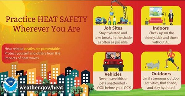
limiting outdoor activity, checking on vulnerable individuals and never leaving children or pets
unattended in vehicles. (Photo courtesy NOAA)
Unsettled Weather Possible
Regarding rainfall chances, the NWS reported that passing showers are expected at times, especially across windward areas during the overnight and morning hours. The NWS said that ponding of water on roads, reduced visibility, and isolated urban and small stream flooding will be possible. Additional unsettled weather could arrive by next week as an area of low-pressure arrives near the islands.
“A wetter and slightly more unstable weather pattern may develop early next week as an upper-level trough approaches the region, increasing the potential for more frequent showers and isolated thunderstorms,” the NWS stated.
Finally, minor amounts of Saharan dust are also expected to affect the region.
“Traces of Saharan dust particles are expected between Friday and Saturday. Although the highest concentrations should remain south of the islands, hazy skies and minor air quality reductions will still be possible,” the NWS explained.

Local Weather Forecast Information
Information regarding the weather across the USVI, including marine forecasts, is available from the NWS and NOAA. With the Atlantic hurricane season set to begin June 1, individuals across the islands are also encouraged to begin preparing for hurricane season.
The local forecast is regularly updated on the Source Weather Page, and a weekly video forecast is available. Additionally, residents and visitors can view weather alerts and disaster preparedness information from the Virgin Islands Territorial Emergency Management Agency.