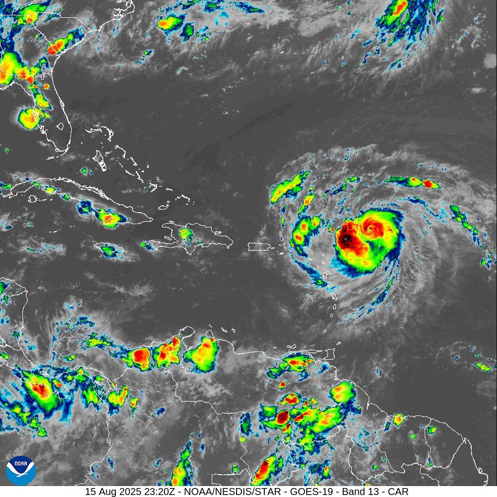
The National Hurricane Center expects Hurricane Erin to pass just north of the U.S. Virgin Islands and Puerto Rico this weekend, bringing the potential for flooding, hazardous seas, and tropical storm-force wind gusts as outer rainbands sweep across the region. Flood watches and marine warnings have been issued across both U.S. territories.
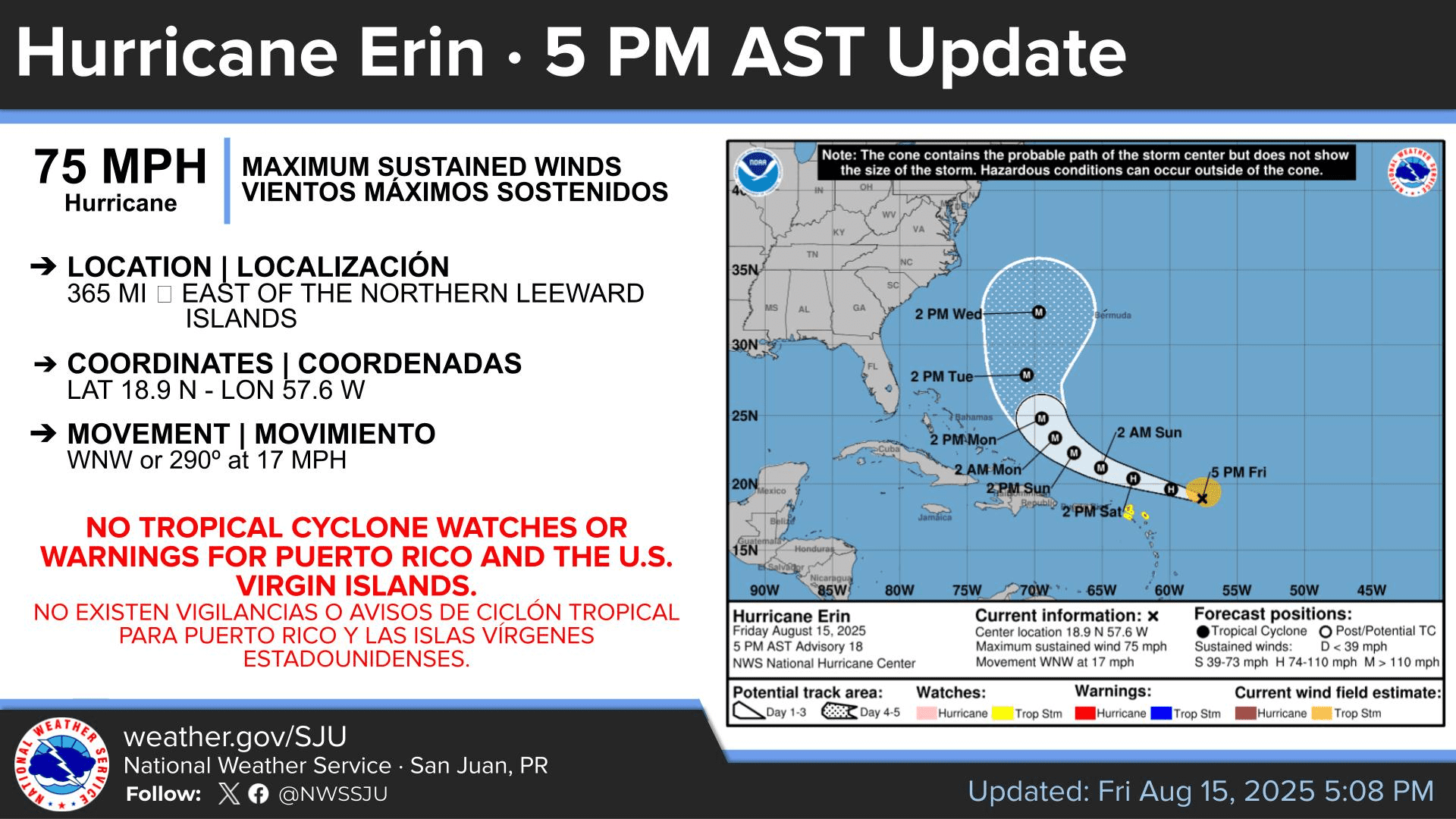
Track of Hurricane Erin
As of the 5 p.m. Friday update from the NHC, Erin was located about 365 miles east of the northern Leeward Islands, moving to the west-northwest at 17 mph and with maximum sustained winds of 75 mph. The Category 1 cyclone, which intensified into the first hurricane of this year’s season Friday morning, continues to strengthen. Rapid intensification of the storm is expected, and Erin is forecast to eventually intensify into a major Category 4 hurricane after passing north of the USVI.
“On the forecast track, the center of Erin is likely to move just north of the northern Leeward Islands, the Virgin Islands, and Puerto Rico over the weekend,” the NHC said.
The U.S. Virgin Islands, the British Virgin Islands, and Puerto Rico had not been placed under any tropical weather watches or warnings as of 5 p.m. Friday. However, the NHC had previously announced on Thursday that a Tropical Storm Watch had been issued for several nearby northern Leeward Islands, including Anguilla, Barbuda, St. Martin, St. Barthelemy, Saba, St. Eustatius, and Sint Maarten. A Tropical Storm Watch remains in effect for those areas, with the exception of Barbuda, where the watch has since been discontinued.
According to information from the NHC, a Tropical Storm Watch means tropical storm conditions with winds of 39 to 73 mph are possible within 48 hours, while a Tropical Storm Warning means those conditions are expected within 36 hours. A Hurricane Watch signals hurricane conditions with winds of 74 mph or higher are possible within 48 hours, and a Hurricane Warning means those conditions are expected within 36 hours.
Marine and Flood Alerts Issued for USVI, Puerto Rico
While the core of the cyclone is forecast to pass north of the U.S. Virgin Islands and Puerto Rico, the NHC said Friday that Erin will likely pass close enough to bring impacts to the local islands, including heavy rainfall, gusty winds, and powerful ocean swells.
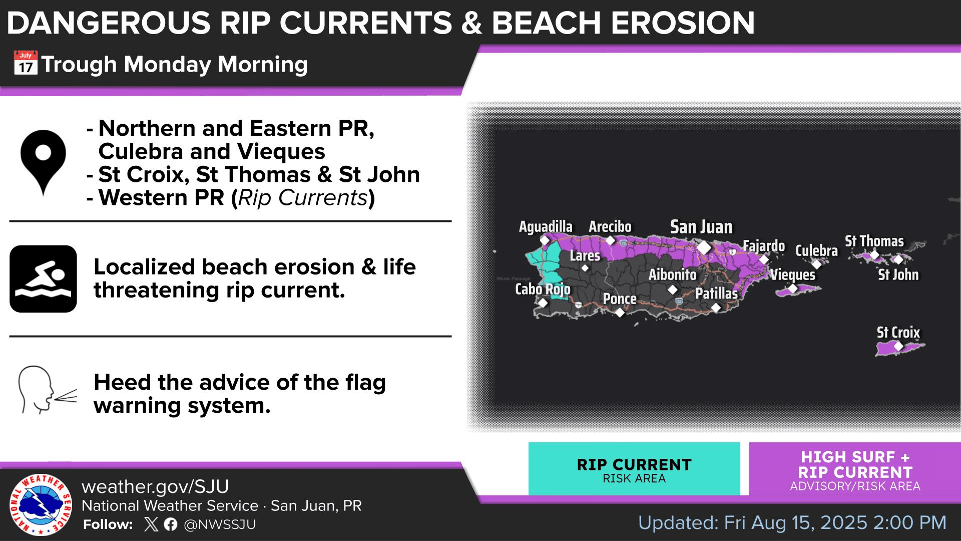
Several severe weather alerts have been issued for the USVI and Puerto Rico, including a Flood Watch, High Surf Advisory, High Rip Current Risk, and Small Craft Advisory. These alerts are set to take effect Saturday and remain in place through at least Monday.
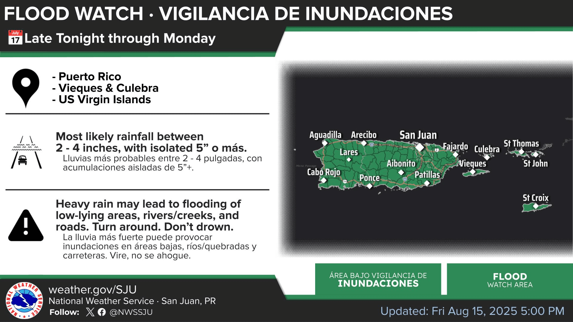
“The outer bands of Erin are expected to produce areas of heavy rainfall Friday night into at least Sunday across the northern Leeward Islands, the Virgin Islands, and Puerto Rico,” the NHC said. Rainfall totals of two to four inches, with isolated totals of six inches, are expected. This rainfall may lead to isolated and locally considerable flash flooding and urban flooding, along with landslides or mudslides,” the NHC continued.
“Swells generated by Erin will begin affecting portions of the northern Leeward Islands, the Virgin Islands and Puerto Rico by this weekend, and will likely spread to the western Atlantic next week. These swells may to cause life-threatening surf and rip current conditions,” the NHC warned.
The NHC added that tropical storm-force winds may begin as early as Saturday across islands currently under a Tropical Storm Watch, with gusts reaching tropical storm strength also possible at times across the U.S. Virgin Islands and Puerto Rico.
“Tropical storm conditions are possible for portions of the northern Leeward Islands, where Tropical Storm Watches are in effect, beginning on Saturday as the core of Erin passes north of those islands. Gusts to tropical storm-force winds are possible in rainbands over portions of the Virgin Islands and Puerto Rico later in the weekend,” according to the NHC.
National Weather Service Information
The National Weather Service in San Juan, Puerto Rico, shared the following information regarding potential impacts from Erin.
“The outer rainbands from Erin are expected to begin affecting the islands as early as late tonight or early Saturday morning, impacting northern and eastern Puerto Rico, Atlantic offshore waters, the Anegada Passage, and the U.S. Virgin Islands,” the NWS said on Friday. “These bands will bring periods of squally weather with thunderstorms, heavy rainfall, and gusty winds between 30 and 40 mph, with higher gusts possible.”
“Activity will become more frequent as Erin continues its trajectory toward the west-northwest, with peak impacts expected by early Sunday morning when it will be moving northeast of the Caribbean islands. However, due to the proximity of Hurricane Erin, winds are expected to shift from the south to southwest on Sunday, drawing deep tropical moisture over the region. This will increase the risk for urban flooding, landslides in steep terrain, and river flooding,” the NWS added.
The NWS also urged caution regarding hazardous marine conditions, noting that wave heights could reach between eight to 12 feet or even higher.
“Swell action from Erin will result in large breaking waves, creating dangerous swimming conditions and potential minor beach erosion, particularly along northern and eastern exposed beaches,” the NWS said.
“High waves can wash over jetties and sweep people and pets onto jagged rocks,” the NWS said. “Rough surf may also knock you down, and large, breaking waves will result in localized beach and dune structure erosion as well as dangerous swimming conditions. Additionally, rip currents can sweep even the best swimmers away from shore into deeper water, where it becomes difficult to return to safety,” the NWS warned.
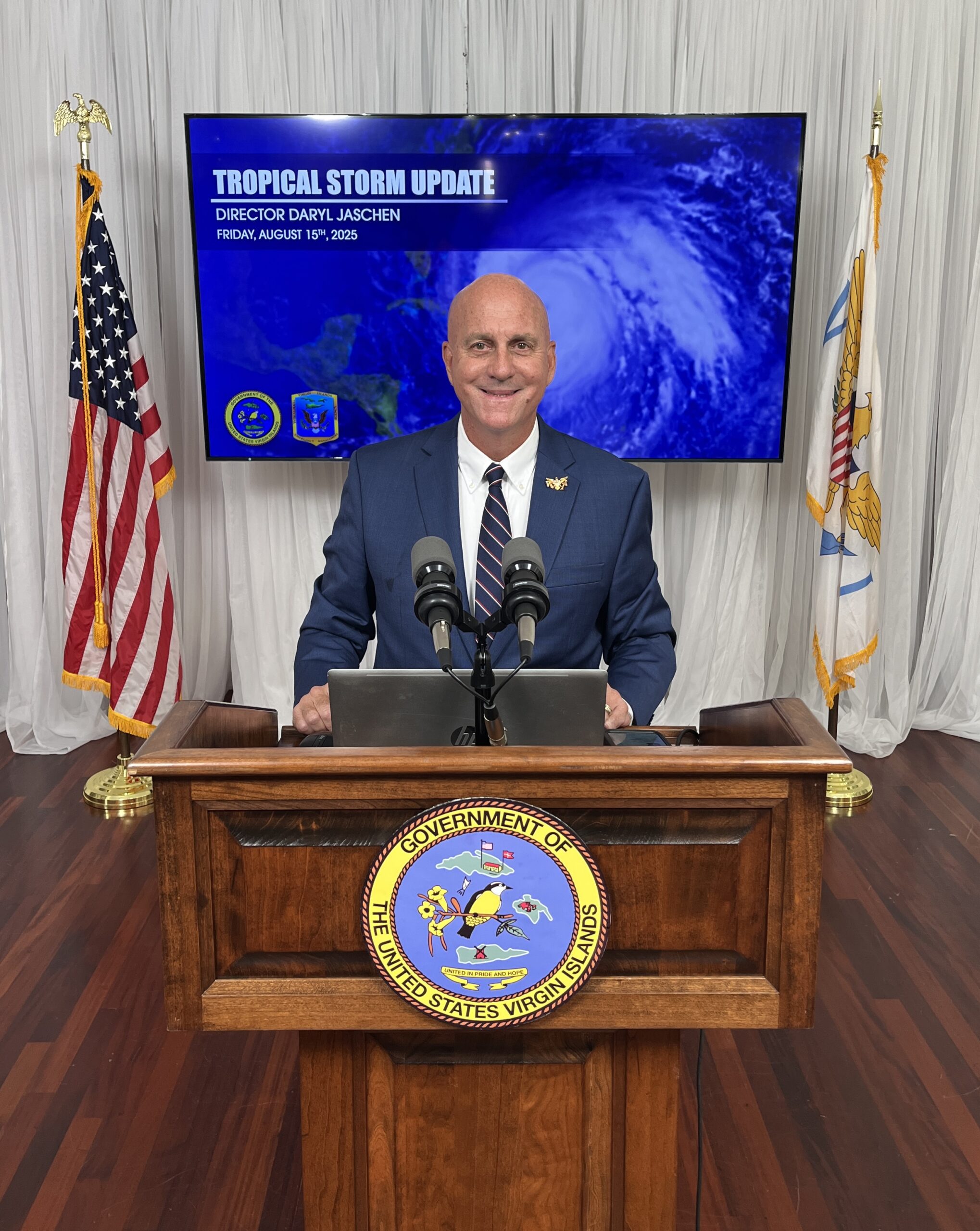
VITEMA Director Shares Update on Tropical Storm Erin
Daryl Jaschen, director of the Virgin Islands Territorial Emergency Management Agency, held a press briefing Friday on Hurricane Erin. Jaschen emphasized that — while the center of Erin will pass north of the local region — rainfall totals could reach three to four inches or more between Friday night through Tuesday. He stressed that seas will be very hazardous with powerful ocean swells, and there will also be a high risk for dangerous rip currents.
Regarding the status of ports across the territory, Jaschen noted that the U.S. Coast Guard will set “Port Condition Yankee” for St. Thomas and St. John by Friday night, while St. Croix ports will remain at “Port Condition X-Ray” until at least Saturday morning.
According to information available online, Port Condition X-Ray indicates that gale-force winds are expected within 48 hours, while Port Condition Yankee is set when gale-force winds are predicted within 24 hours.
Jaschen also reminded USVI residents about “Operation Blue Skies,” a sandbag distribution operation across the territory that began on Thursday and will occur until Saturday. Originally planned for later this month, the distribution was moved up due to uncertainty surrounding Hurricane Erin. VITEMA noted this will be the only sandbag distribution for the 2025 Atlantic hurricane season.
Locations for sandbag distribution were provided in a VITEMA press release earlier this week and VITEMA announced that sandbag distribution is suspended for Saturday at all locations due to an increased risk of flooding.
Local Weather Updates
It is crucial to remember that the forecast can change very quickly. USVI residents and visitors are encouraged to continue to remain prepared. Weather information is available from the NWS, the NHC, and NOAA.
The local weather forecast for the U.S. Virgin Islands is regularly updated on the Source Weather Page and VI Source YouTube Channel. A weekly Tropical Outlook article from the Source is also published throughout hurricane season to provide in-depth updates.
Additionally, residents and visitors can find weather details and preparedness information from VITEMA.