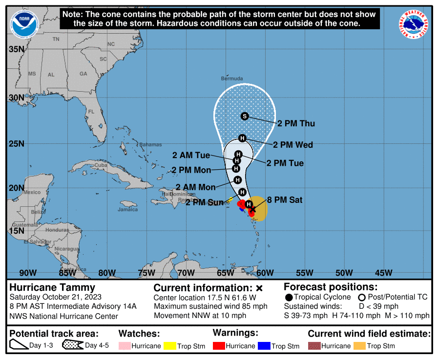
An 8:00 p.m. update from the National Hurricane Center (NHC) on Saturday notes that Hurricane Tammy is packing maximum sustained winds of about 85 mph and is moving to the north-northwest at approximately 10 mph. The system is on track to pass to the northeast of the USVI and Puerto Rico, bringing the potential for heavy rain to the region. However, it is essential to monitor weather updates, as the forecast can quickly change.
Multiple tropical weather alerts, including hurricane watches and warnings, remain in effect for islands across the Lesser Antilles, including a “Tropical Storm Watch” for the British Virgin Islands. (As of 8 p.m. on Saturday, the NHC has not issued tropical storm or hurricane alerts for the USVI and Puerto Rico.)
“Tammy is moving toward the north-northwest near 10 mph (17 km/h), and this general motion is expected through Sunday, followed by a turn toward the north on Monday. On the forecast track, the center of Tammy will move near or over portions of the Leeward Islands tonight and then move north of the northern Leeward Islands by Sunday afternoon,” according to the NHC update.
The USVI and Puerto Rico may receive between one and two inches of rain, with locally higher amounts of up to four inches, and flash flooding and mudslides are possible. Tammy may also produce choppy seas and gusty winds as it passes by the region.
A “Small Craft Advisory” is in effect for portions of the local waters around the islands until at least Monday, and there will be a moderate risk of rip currents.
“On the current forecast track, the closest approach from Tammy’s center would be around 138 miles NE of St. John, 156 mi NE of St. Croix, and around 216 mi ENE of San Juan,” according to an update from the National Weather Service (NWS) in San Juan, P.R.
“However, the local area is still expected to be indirectly impacted by Tammy in the form of occasional outer rainbands and feeder rainbands reaching the region during the weekend, bringing periods of locally heavy rains, thunderstorms, and sudden locally higher winds and gusts,” the NWS update cautions.
Monitor the Storm Track
Any slight shifts in the cyclone’s path could change the weather forecast rapidly. USVI visitors and residents are encouraged to follow the National Hurricane Center for the latest weather alerts.
Information about severe weather, including emergency shelters and alerts, is also available from the Virgin Islands Territorial Emergency Management Agency and the National Weather Service.
Daily weather updates are published on the Source Weather Page, where readers can find a “Weekly Weather Update” video.