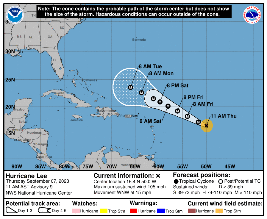
As of the 11:00 a.m. update from the National Hurricane Center (NHC) on Thursday, Hurricane Lee is rapidly intensifying. While not guaranteed, the NHC has more confidence that the system will pass to the north of the USVI and Puerto Rico.
Hurricane Lee is moving toward the west-northwest at approximately 15 mph, and it is now packing maximum sustained winds of approximately 105 mph. The storm is expected to intensify further as it travels across the ocean.
“Lee is forecast to become a major hurricane later today, with its core moving north of the northern Leeward Islands, the Virgin Islands, and Puerto Rico this weekend and early next week,” according to the 11 a.m. update from the NHC. “The potential for tropical storm conditions to occur in the islands is decreasing, but residents there should continue to monitor updates on Lee,” the NHC cautioned.
The NHC notes that powerful swells created by the cyclone may impact the islands this weekend.
“Swells generated by Lee are expected to reach portions of the Lesser Antilles on Friday and the British and U.S. Virgin Islands, Puerto Rico, Hispaniola, the Bahamas, and Bermuda this weekend. These swells are likely to cause life-threatening surf and rip current conditions,” the NHC explained.
A press release from the Government of the U.S. Virgin Islands (GVI) on Thursday morning explains that, given the updated storm track forecast, plans for sandbag distribution have been discontinued.
“Due to the continued changes in the forecast of Hurricane Lee moving away from the U.S. Virgin Islands, there will be no sandbag or sand distribution today (Thursday, Sept. 7) or tomorrow (Friday, Sept. 8) at the Department of Public Works or the VI fire stations on St. Thomas, St. John, or St. Croix,” according to the GVI update.
Continuing to Monitor the Storm
Changes in the storm track are possible, and regardless of how close the system tracks to the USVI and Puerto Rico, some impacts are expected, including rough seas up to 12 feet. Updates will be posted to the Source Weather Page as they become available.
USVI residents and visitors can locate more information about the weather, including locations of emergency shelters and severe weather alerts, from the Virgin Islands Territorial Emergency Management Agency website and the National Weather Service.
Information from the National Weather Service about hurricane preparedness is available here.