The National Hurricane Center is tracking Major Hurricane Melissa, expected to strike Jamaica starting late Monday night. While no tropical alerts are in effect for Puerto Rico or the U.S. Virgin Islands, Melissa’s circulation will still influence local weather, bringing unsettled conditions through the week.
National Hurricane Center: Hurricane Melissa
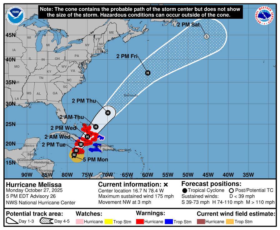
As of Monday afternoon, the NHC noted that Hurricane Melissa was located approximately 140 miles southwest of Kingston, Jamaica, moving very slowly toward the northwest and packing ferocious winds of approximately 175 mph, making the system a major Category 5 hurricane. Melissa is expected to fluctuate between the intensity of a Category 4 and 5 cyclone as it crawls toward the southern coastline of Jamaica.
Hurricane Melissa underwent “extreme rapid intensification” this weekend, resulting in an explosive cyclone. Extreme rapid intensification occurs when a cyclone experiences “an increase in maximum sustained winds of at least 50 kt., about 58 mph, in a 24-hour period,” according to ClimateCentral.org. This is an even faster rate of strengthening than “rapid intensification,” which the NHC defines as “an increase in the maximum sustained winds of a tropical cyclone of at least 30 kt., about 34 mph, in a 24-hour period.”
Hurricane Melissa, the third hurricane to reach Category 5 status in the Atlantic basin so far this season, is forecast to cause catastrophic wind, flooding, and storm surge impacts across Jamaica, and the system may become the strongest hurricane to make a direct hit on the island in recorded history. Extensive damage is also expected across portions of Haiti, the Dominican Republic, and Cuba, before moving toward the Southeastern Bahamas and the Turks and Caicos Islands.
“At 5:00 p.m. EDT, the eye of Hurricane Melissa was located near latitude 16.7 North, longitude 78.4 West,” according to an update from the NHC on Monday afternoon. “Melissa is moving toward the northwest near 3 mph, and a slow turn toward the north is expected Monday evening, followed by a turn toward the northeast and a slightly faster forward speed on Tuesday. A northeastward motion with a faster forward speed is expected on Wednesday and Thursday. On the forecast track, the core of Melissa is expected to move near or over Jamaica late tonight and Tuesday, across southeastern Cuba Tuesday night, and across the southeastern or central Bahamas on Wednesday,” the NHC said.
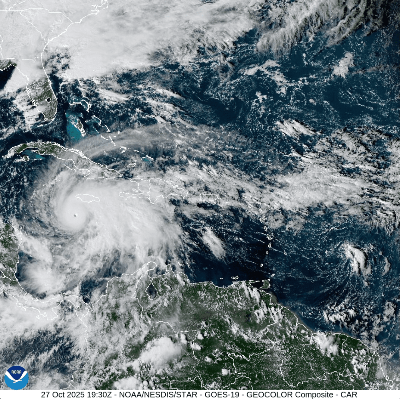
“Maximum sustained winds are near 175 mph with higher gusts. Melissa is a Category 5 hurricane on the Saffir-Simpson Hurricane Wind Scale. Some fluctuations in intensity are likely before Melissa makes landfall on Jamaica. However, Melissa is expected to reach Jamaica and southeastern Cuba as an extremely powerful major hurricane and will still be at hurricane strength when it moves across the southeastern Bahamas. Hurricane-force winds extend outward up to 30 miles from the center and tropical-storm-force winds extend outward up to 195 miles. The estimated minimum central pressure is 906 millibars,” the NHC continued.
Multiple hurricane and tropical storm alerts have been issued for areas across the Western Caribbean, the Bahamas, and the Turks and Caicos Islands. No tropical cyclone alerts have been issued for the U.S. Virgin Islands or Puerto Rico.
Local Weather Impacts
Hurricane Melissa is located far from the U.S. Virgin Islands and Puerto Rico. However, the National Weather Service in San Juan, Puerto Rico, indicated that the weather pattern generated by Melissa is expected to indirectly influence local conditions this week. Moisture drawn across the northeastern Caribbean will help to support scattered showers and isolated thunderstorms. While widespread flooding is not expected, the NWS has warned of a limited to elevated risk of flooding in localized areas throughout the week, especially as the storm eventually moves north of Jamaica.
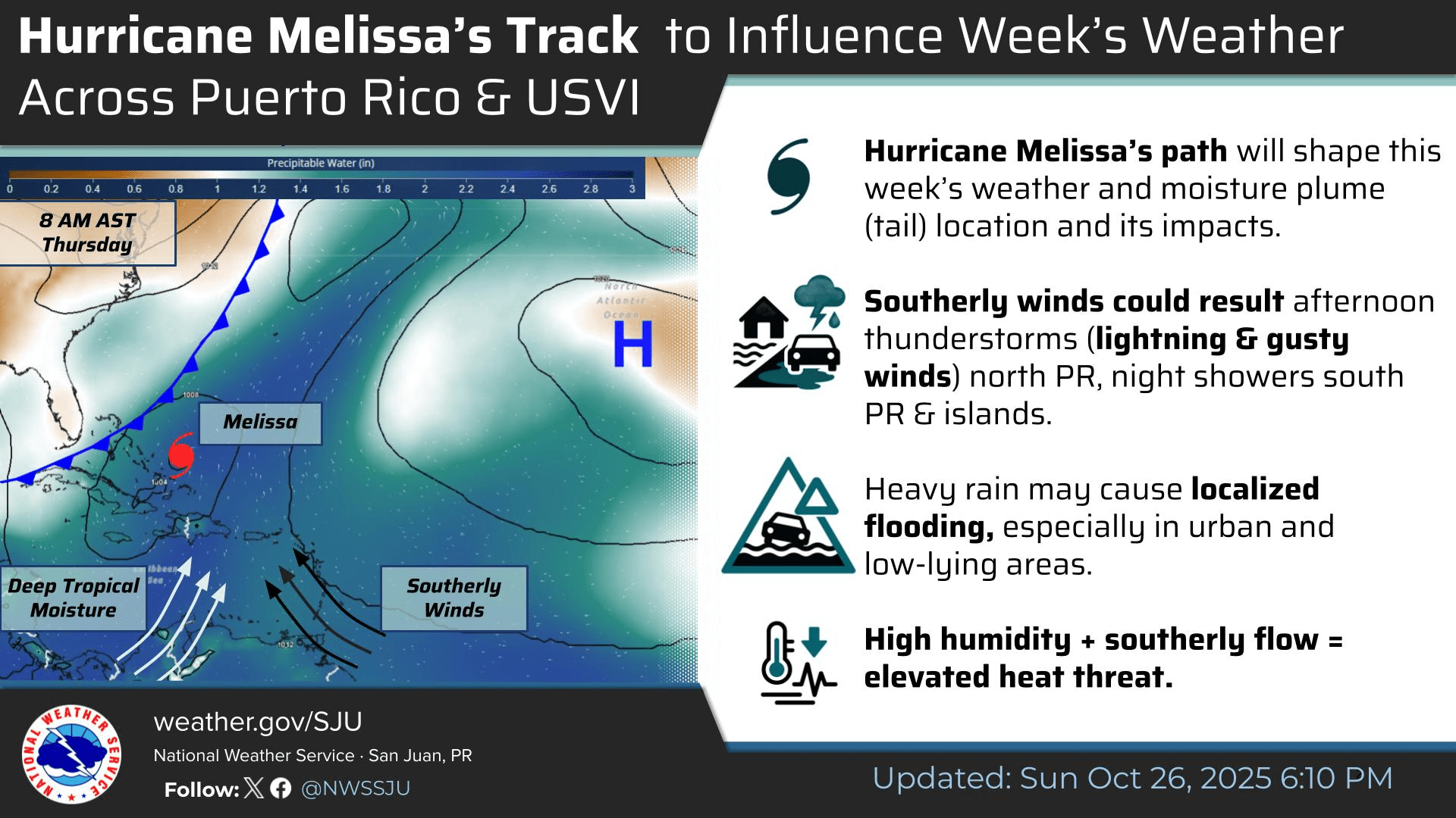
“A moist and marginally unstable weather pattern will persist across the local islands through midweek as Hurricane Melissa slowly moves northward well northwest of the area,” the NWS said on Monday. “The system’s broad circulation, in combination with a strengthening surface high pressure over the central Atlantic, will maintain a southeasterly to southerly wind flow across Puerto Rico and the U.S. Virgin Islands, particularly Tuesday onward. This pattern will continue to draw deep tropical moisture across the region,” the NWS stated.
Marine and coastal conditions may also be affected. A moderate risk of rip currents will continue into Tuesday across most beaches in Puerto Rico and the USVI, with the risk increasing by midweek as a swell from Melissa reaches the islands. Choppy seas are likely, particularly across north-facing beaches.
“A moderate risk of rip currents will continue Tuesday for most beaches in Puerto Rico and the U.S. Virgin Islands,” the NWS explained. “By midweek, the risk of rip current threat will increase to a high risk along some of the north facing beaches of Puerto Rico and USVI due to a small northwest swell from Major Hurricane Melissa. Beachgoers are advised to closely monitor the local forecast as well as the evolution and track of Melissa for updated information. In addition, showers and isolated thunderstorms can form near coastal areas, especially during afternoon hours,” the NWS predicted.
Additionally, the NWS said that breezy conditions and warm temperatures with high humidity are expected to continue across both territories for several days, with the potential for heat alerts.
Stay Informed
It is important to remember that the forecast, including the tropical outlook, can change quickly. The Atlantic hurricane season officially ends on Nov. 30, and USVI residents and visitors are encouraged to continue to remain prepared. Weather information is available from the NWS, the NHC, and NOAA.
The local weather forecast for the U.S. Virgin Islands is regularly updated on the Source Weather Page and VI Source YouTube Channel. A weekly Tropical Outlook article from the Source will continue to be published throughout the remainder of hurricane season to provide in-depth updates. Residents and visitors can find additional weather alerts and preparedness information from the Virgin Islands Territorial Emergency Management Agency.