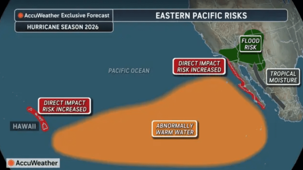
Caption: AccuWeather’s 2026 hurricane season forecast highlights elevated Eastern Pacific risks, including abnormally warm water, increased direct impact potential near Hawaii and parts of Mexico, and tropical moisture concerns. (Photo courtesy AccuWeather)
The National Hurricane Center will resume routine Tropical Weather Outlooks for the Atlantic basin on May 15, giving residents and visitors across the U.S. Virgin Islands another reminder that the 2026 Atlantic hurricane season is fast approaching.
The Atlantic hurricane season officially begins June 1 and runs through Nov. 30. For the U.S. Virgin Islands, the Atlantic basin is the key area to monitor, because it includes the Atlantic Ocean, Caribbean Sea and the Gulf.
The outlooks are a key place to check whether the NHC is monitoring areas of disturbed weather for possible tropical development. The May 15 restart also comes as forecasters continue to monitor the potential development of El Niño, which can influence hurricane activity differently across the Atlantic and Pacific basins.
Why Tropical Outlooks Resume on May 15
The Source contacted Alex DaSilva, lead hurricane expert at AccuWeather, for perspective on the May 15 restart of the NHC outlooks. DaSilva explained that the timing of the resumption of outlooks can help improve awareness ahead of the official June 1 start of the Atlantic season.
“May 15 marks the start of the Eastern Pacific hurricane season, and the NHC likely begins Atlantic outlooks at the same time for consistency between the two basins,” DaSilva said. “Starting both at the same time helps avoid confusion and also raises awareness in the Atlantic ahead of the official June 1 start of the season.”
Tropical cyclone seasons vary around the world depending on the basin and time of year. For residents and visitors in the U.S. Virgin Islands, the Atlantic basin remains the primary area to monitor. The National Hurricane Center states that the Atlantic hurricane season runs from June 1 through Nov. 30, while the Eastern North Pacific season begins May 15 and runs through Nov. 30. The Eastern North Pacific basin covers the area east of 140 degrees west longitude, and the Central North Pacific basin covers the area from 140 degrees west longitude to 180 degrees, with that season also running from June 1 through Nov. 30.
In the Southern Hemisphere, tropical cyclone seasons occur during a different time of year. For example, Australia’s official tropical cyclone season runs from Nov. 1 to April 30, according to the Australian Bureau of Meteorology.
NWS San Juan Urges Preparedness
The Source also contacted Yidiana Zayas-Rivera, a meteorologist with the National Weather Service in San Juan, Puerto Rico, for comments ahead of the NHC daily outlooks. Zayas-Rivera stressed that disaster preparedness remains important every year, no matter what the seasonal forecasts predict.
“Regardless of whether the season is expected to be more or less active, it is always important to focus on things we can control, and that is preparedness,” Zayas-Rivera declared. “We need to be prepared, because it only takes one hurricane to make a season active. Preparation, education, and our information are key to helping save lives,” she continued.
“Also, remember to follow official resources such as the NHC for the official intensity forecasts and forecast tracks of tropical systems, and the local San Juan Weather Forecast Office for more details on local impacts,” Zayas-Rivera noted.
El Niño Chances Continue to Grow
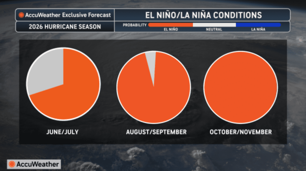
El Niño/La Niña conditions are shown for the 2026 hurricane season, with AccuWeather forecasting El Niño conditions becoming increasingly likely through the peak and latter part of the season. (Photo courtesy AccuWeather)
A major factor that may influence this year’s Atlantic hurricane season is the expected development of a strong El Niño weather pattern.
El Niño, which involves a warming of the equatorial Pacific Ocean, usually helps to increase wind shear—a change in wind direction and velocity with height in the atmosphere. In the Atlantic Ocean the increase in wind shear from El Niño helps to rip apart storms and prevent hurricane formation and intensification. This is the opposite of a La Niña cycle, when the ocean waters across the equatorial Pacific cool significantly. During La Niña, wind shear typically decreases in the Atlantic, and a reduction in wind shear can favor cyclone development.
The latest update from NOAA’s Climate Prediction Center was released on May 14 and adds additional context to the potential development of El Niño this year. In its latest ENSO Diagnostic Discussion, NOAA said ENSO-neutral conditions continued over the past month, and an El Niño Watch remains in place.
The update said El Niño is likely to emerge soon, with an 82% chance during May through July 2026, and continue through winter 2026-2027, with a 96% chance for December through February. NOAA also noted that confidence in the development of El Niño has increased since last month, though there is still uncertainty about how strong the event may become.
AccuWeather has highlighted the developing El Niño pattern in recent outlooks. In an April 29 summer forecast, AccuWeather reported, “El Niño is expected to develop early in the summer and will have a growing influence on the tropics and the broader weather pattern across the United States through the rest of 2026.”
In a separate AccuWeather report about the Pacific hurricane season, the outlet noted that El Niño could promote a surge in activity in 2026 across the Pacific region. The report quoted DaSilva as saying, “This could be an unusually active and potentially impactful year in the Pacific basin, unlike the Atlantic basin, where we are forecasting fewer storms than the historical average.”
Atlantic Season Could Be Less Active, But Still Dangerous
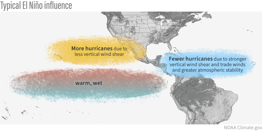
A NOAA Climate.gov graphic shows the typical influence of El Niño, including more favorable hurricane conditions in the eastern Pacific and fewer hurricanes in the Atlantic due to stronger vertical wind shear, stronger trade winds, and greater atmospheric stability. (Photo courtesy NOAA)
DaSilva shared additional details regarding how El Niño affects the weather, including hurricane season.
“El Niño typically leads to fewer storms in the Atlantic, because it increases wind shear, creating hostile upper-level winds that disrupt tropical development. That tends to keep storm numbers lower overall, with more frequent periods of wind shear across the basin. It’s the opposite in the Pacific region, when during El Niño, there is generally less wind shear, which allows for more active hurricane seasons there.”
“Overall, wind shear this season is expected to be higher across the Atlantic, which should limit development for much of the season,” DaSilva predicted. “However, the wind shear will not be constant, and there will still be periods of lower wind shear. Those are the opportunities when powerful storms can form, especially with very warm ocean temperatures. The stronger El Niño becomes, the lower the total number of storms is likely to be. If we reach a very strong “super El Niño,” storm totals would likely fall toward the lower end of the hurricane forecast range,” he said.
Still, DaSilva noted that the northeastern Caribbean should not ignore the season, even if the overall Atlantic number of cyclones could be lower than average.
“I am concerned about the northeastern Caribbean potentially being grazed by a couple of systems this year,” DaSilva stated. “Storm tracks could be similar to last year, where systems approach the region and then turn north and away from the islands. While many storms may recurve, there is still a risk that some could come close enough to bring impacts, especially to the northern and northeastern Caribbean. Even in a quieter season, it only takes one storm. That is why preparation is critical every year, regardless of the forecast,” he warned.
Additionally, DaSilva said a quieter season does not eliminate the risk of a dangerous hurricane.
“Ocean temperatures are expected to be extremely warm, and ocean heat content will be very high, and any storm that finds a pocket of lower wind shear could rapidly intensify,” DaSilva cautioned. “People may see a season with fewer storms and assume there is little to worry about, but that can actually make it more dangerous. People may let their guard down. Even with lower numbers, it only takes one storm in the right conditions to become a high-impact hurricane. That’s why it’s critical to take this season seriously and have a hurricane plan in place. We are particularly concerned about areas along the northern and northeastern Gulf Coast and the Carolina coastline this season,” DaSilva continued.
Residents Should Remain Vigilant
For the U.S. Virgin Islands and Puerto Rico, seasonal outlooks can help describe the larger pattern, but they cannot predict whether any one island will be affected. DaSilva said early-season activity may occur before El Niño fully strengthens.
“There is a possibility of early-season tropical activity, because wind shear may be lower before El Niño fully strengthens, which could allow for some development,” DaSilva explained. “As El Niño builds, wind shear would likely increase, especially later in the season. For the Caribbean, especially the eastern Caribbean, the highest risk typically comes starting in July and increasing into August. Early in the season, it is more common to see tropical waves that have not fully developed yet. If El Niño becomes very strong, especially a super El Niño, wind shear would likely be stronger during the second half of the hurricane season,” DaSilva concluded.
The takeaway for the Virgin Islands remains straightforward: even if El Niño helps reduce the overall number of Atlantic storms, residents and visitors should use the coming weeks to review plans, follow official forecasts, and make sure emergency supplies are ready.