The majority of participants in a virtual town hall agreed on proposed signage and a gate for a popular hiking area on the East End of St. Croix. Presenters from The Nature Conservancy, East End Marine Park, University of the Virgin Islands and Department of Planning and Natural Resources outlined the proposal for the participants.
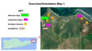
Celeste Jarvis, director of The Nature Conservancy, narrated a slide show with photos of proposed signs and a gate to prevent four-wheeling vehicles from plowing new trails. The Nature Conservancy owns the land, and it is managed by the V.I. government.
The placement of the gate will prevent vehicles from driving Goat Hill, where at least one car has gone over a cliff, destroying the vehicle. The passengers had jumped out and were safe before the vehicle plunged an estimated 600 feet, she said.
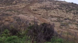
“Once somebody drives that, it looks like a road and everybody does it,” Jarvis said of the obvious dirt trails up and down Goat Hill created by vehicles.
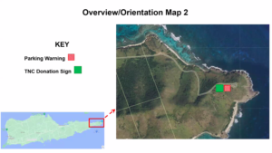
The signs will label areas with “No Parking” and “No Vehicles” messages and welcome and informational signs will give the background and history of the area and identify plants. Signs will be placed near Point Udall labeling trails to Jack and Isaac bays.
John Farchette, park ranger for DPNR, Coastal Zone Management and the East End Marine Park, said the DPNR enforcement officer has the authority to enforce the regulatory signs. The V.I. Police Department can also impose fines for ignoring the rules, he added.
During the public comment section, several of the more than 30 participants asked about scheduling more education for and about the area. They were told cameras for the parking areas will be added to the plan but there is no concrete date when the signs will be placed.
Olassee Davis, a professor at the University of the Virgin Islands, said he had given impromptu talks to hikers using some of the trails and a sign about how to get more information is needed. He told the audience a good source of educational materials is the East End Marine Park Visitors Center at 5005 Estate Great Pond. He also recommended signing up for walking tours, snorkel tours or the seagrass patrol.
Jarvis discussed some reasons for preserving the land around Goat Hill, including a pre-Columbian site and endangered and indigenous plant species. Another problem – run-off from erosion – degrades the land to the shoreline and covers reefs at Brown Bay and Boiler Bay with soil, killing them. Reefs protect the land from storm surge and feed fish, she added.
Tourist revenue is as much as $275 million for the territory, Jarvis said, and many tourists visit the East End beaches as well as Point Udall, which he said is another reason to preserve the area.
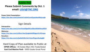
The public can comment on the proposal until Oct. 1 by emailing usvi@tnc.org. The slide presentation and details about the signs are available online. (See accompanying graphics for addresses.) A hard copy of the plan can be picked up at the DPNR office at 45 Mars Hill, Frederiksted.