In an update released Thursday, the National Oceanic and Atmospheric Administration reaffirmed its forecast for an above-normal Atlantic hurricane season, pointing to very warm ocean temperatures and favorable atmospheric conditions that remain in place as the season enters its peak months.
While the predicted number of named storms was slightly reduced from the initial forecast released in May, NOAA emphasized that the season is still expected to be active and urged residents to remain prepared.
NOAA shared the following information in Thursday’s updated hurricane season forecast:
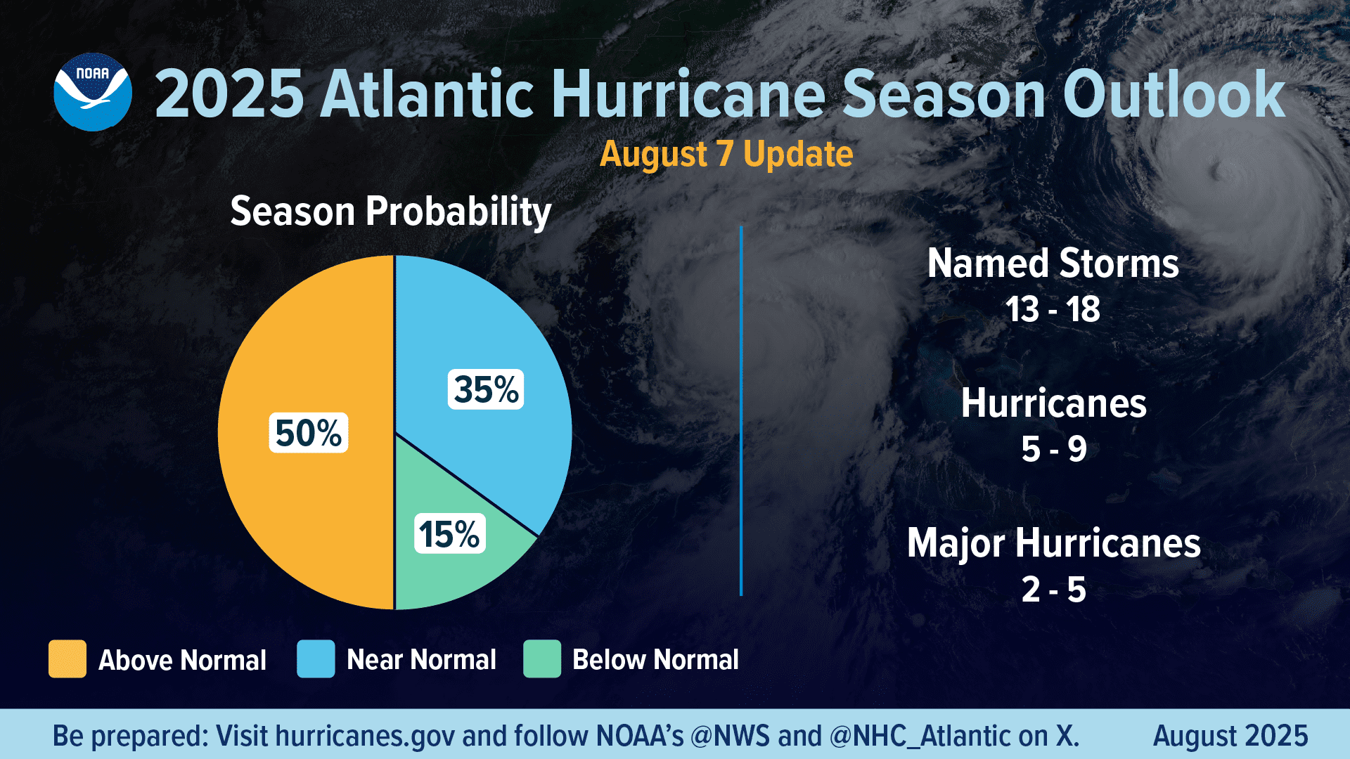
“Forecasters from NOAA’s National Weather Service updated the number of expected named storms to 13 to 18, with winds of 39 mph or greater, of which five to nine could become hurricanes, with winds of 74 mph or greater, including two to five major hurricanes with winds of 111 mph or greater.
“The adjusted ranges are for the entire season from June 1 through Nov. 30, and are inclusive of the four named tropical storms that have already formed. In the Atlantic basin, a typical hurricane season will yield 14 named storms, of which seven become hurricanes and three become major hurricanes.
“The likelihood of above-normal activity is 50%, a 35% chance of a near-normal season, and a 15% chance of a below-normal season. This updated prediction is similar to the initial outlook issued in May.”
NOAA’s updated forecast highlights environmental conditions that remain favorable for tropical cyclone formation, including warm Atlantic Ocean temperatures and a busy West African Monsoon, which often generates tropical waves off the coast of Africa. Forecasters also cited the current neutral phase of the El Niño-Southern Oscillation, which can help to reduce wind shear and allow storms to organize more easily.
“Atlantic basin tropical storm activity is expected to be elevated due to a combination of factors, including warmer-than-average sea surface temperatures in the tropical Atlantic Ocean and Caribbean Seas, and an active West African Monsoon,” NOAA said. “ENSO-neutral conditions are expected to continue, meaning there is neither an El Niño nor La Nina to influence this season’s storm activity,” NOAA continued.
“‛Many of the factors we identified ahead of the season are still at play, and conditions are largely tracking along with our May predictions,’ said Matt Rosencrans, lead hurricane season forecaster with NOAA’s National Centers for Environmental Prediction, part of the National Weather Service,” NOAA’s press release added.
Additionally, forecasts for the Eastern and Central Pacific basins also remain consistent, according to NOAA.
“NOAA’s outlook for a below-average Eastern Pacific season — with 12 to 18 named storms — remains on track, but it did have a rapid start with nine named storms. The Central Pacific hurricane season remains unchanged, calling for one to four named storms,” NOAA reported.
Atlantic Basin Tropical Cyclones
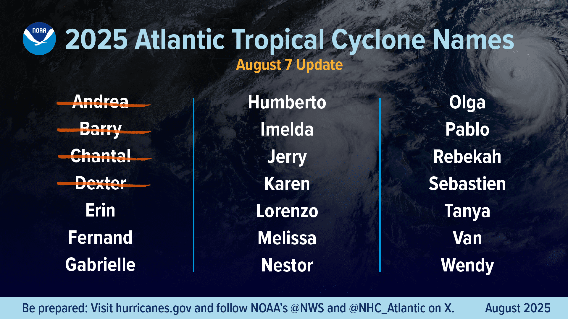
As of Thursday afternoon, four named cyclones have developed in the Atlantic basin since the hurricane season began on June 1.
“So far, the season has produced four named tropical storms and no hurricanes. Tropical Storm Chantal made the first U.S. landfall of the season and brought high winds and deadly flooding to the Carolinas during the Independence Day holiday weekend,” NOAA reported.
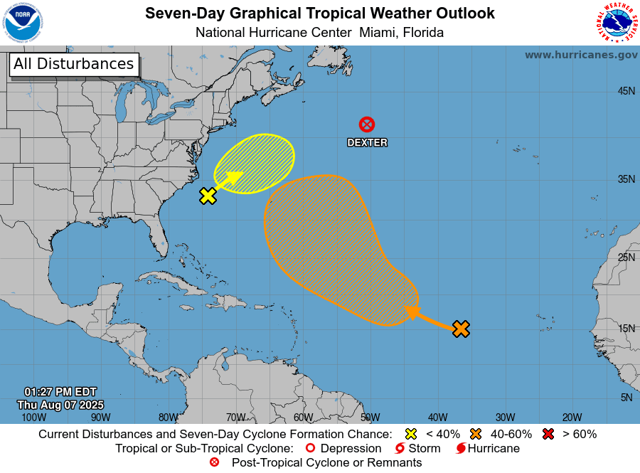
The National Hurricane Center is currently monitoring several disturbances across the Atlantic basin, including Invest 96L, a tropical wave moving westward across the central tropical Atlantic. An “invest” is a system being investigated for potential tropical development.
As reported Wednesday in a Tropical Outlook story by the Source, meteorologists are closely watching the track of Invest 96L, which may pass to the northeast of the Lesser Antilles in the coming days.
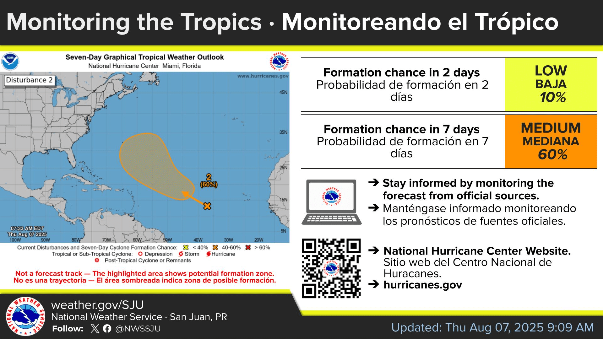
Still, on Thursday, the National Weather Service in San Juan, Puerto Rico, noted that some uncertainty remains regarding any possible impacts from the disturbance.
“Forecast model guidance has been very inconsistent in the last few days with the track of this system,” the NWS said. “However, there is a trend for this tropical system to remain northeast and away from the northeastern Caribbean region. At this time, the forecast confidence remains low, and it is too early to determine impacts associated with the systems for the region. Despite the model trends for early next week, an increase in moisture over the area is anticipated next Monday, followed by much drier air and Saharan dust on Tuesday,” the NWS explained.
However, a second tropical wave expected to move off the west coast of Africa in the coming days could potentially pose a threat to the Caribbean by mid-August.
“Some global forecast models indicate the possible cyclonic formation later in August,” the NWS said in a message to the Source on Wednesday. “However, given its long-range nature, confidence in the forecast is very low at this time. No action is needed for now, but staying informed is essential,” the NWS added.
Local Weather Updates
Residents and visitors in the U.S. Virgin Islands are encouraged to monitor tropical updates regularly, as forecasts can change quickly. Weather information is available from the NWS, the NHC, and NOAA.
Additionally, the local weather forecast for the U.S. Virgin Islands is regularly updated on the Source Weather Page and VI Source YouTube Channel. A weekly Tropical Outlook article from the Source is also published throughout hurricane season to provide in-depth updates.
Finally, residents and visitors can find weather details and preparedness information from the Virgin Islands Territorial Emergency Management Agency.