Sargassum levels across the Atlantic and Caribbean remained above normal in February, and researchers say the region remains on track for another major sargassum year in 2026. A new outlook from the University of South Florida’s Optical Oceanography Lab found continued growth with further increases expected.
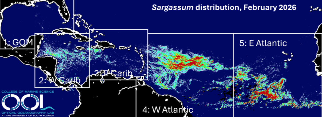
The OOL at USF monitors the presence of sargassum across the Atlantic, Caribbean, and Gulf regions using satellite imagery. The group’s February 2026 outlook, released Feb. 28, found that overall amounts continued to increase across much of the Atlantic and Caribbean region. With the exception of the eastern Atlantic, USF noted that February sargassum totals were at record highs for the month compared with historical observations.
“As predicted in January 2026, sargassum in most regions continued to grow, including the western Caribbean, western Atlantic, and eastern Atlantic,” USF explained. “In the Gulf and eastern Caribbean, total sargassum amount remained stable. Except for the eastern Atlantic region, every other region continued to see record high sargassum amount for the month of February. The distribution map continued to show three separated large masses in the eastern Atlantic, western Atlantic, and the western Caribbean, respectively,” USF said.
Beaching Events Across the Region
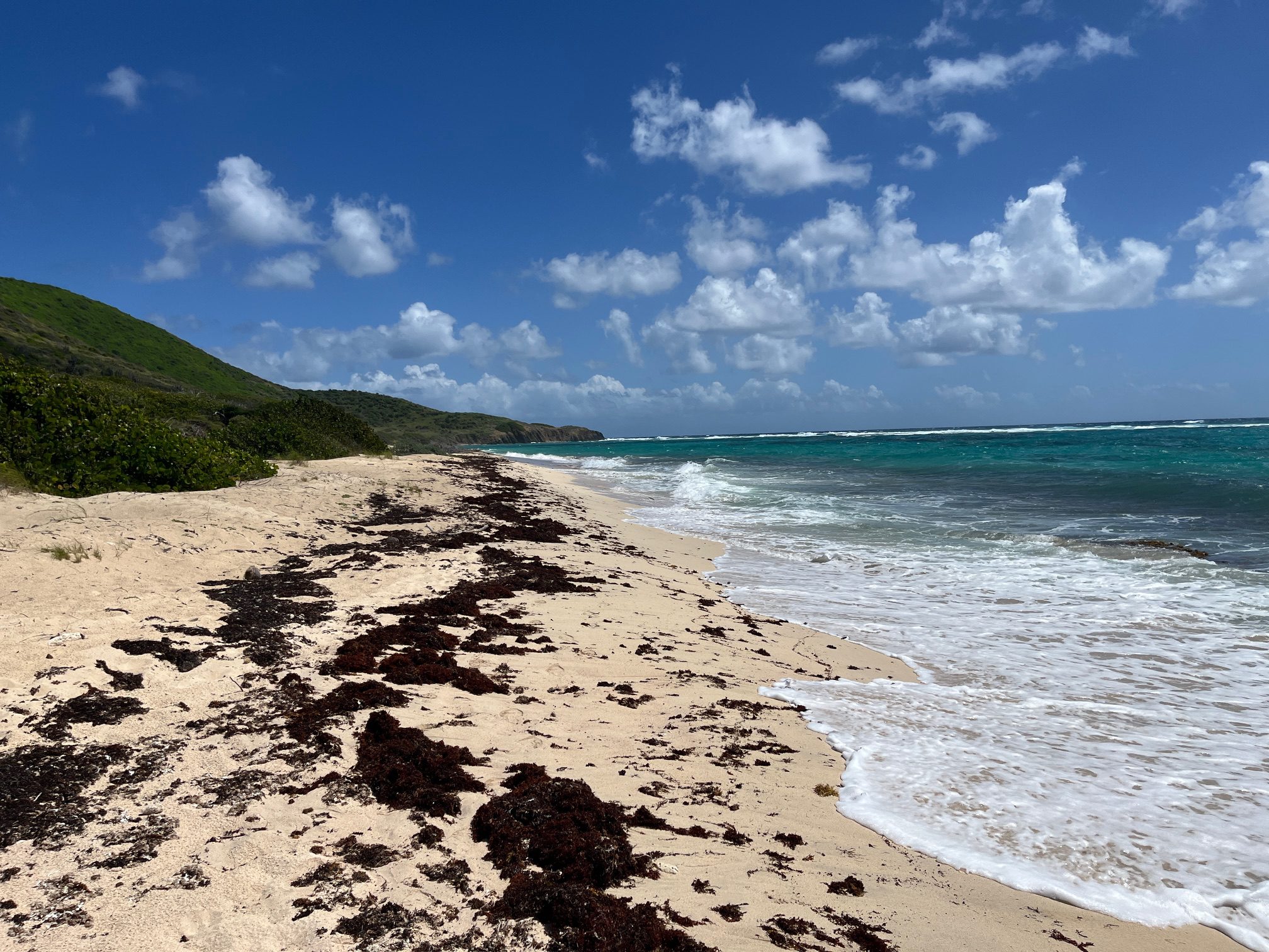
The February outlook indicated that seaweed beaching events likely occurred along parts of the western Caribbean, including areas of Belize, Honduras, and Mexico’s Caribbean coast. Islands across the Lesser Antilles, including the U.S. Virgin Islands, may also have experienced increased accumulations, particularly along windward-facing shores, where prevailing trade winds push floating mats toward land.
These offshore accumulations serve as source regions that can be transported toward coastlines by currents and seasonal wind patterns in the months ahead.
While the USF outlook does not provide beach-specific forecasts, the U.S. Virgin Islands typically begin seeing increased sargassum arrivals in late spring and summer as seasonal currents transport floating mats into the northeastern Caribbean. However, beaching events and larger inundations can vary widely from one shoreline to another depending on wind direction, wave exposure, and local coastal features.
In order to help contain beaching events along the USVI, as reported in a previous Source interview with Amy Dempsey, a marine biologist and founder of the consulting firm Bioimpact, Inc., officials in the territory have begun using floating barriers to divert incoming mats of sargassum before they reach the shoreline. The booms have shown promise in keeping beaches clearer, but they require constant upkeep due to strong currents and storm damage and must be removed ahead of approaching cyclones.
Sargassum Explained
Another Source article included information about sargassum through an interview with Yuyuan Xie, Ph.D., a research scientist at USF. Xie is involved with the university’s OOL.
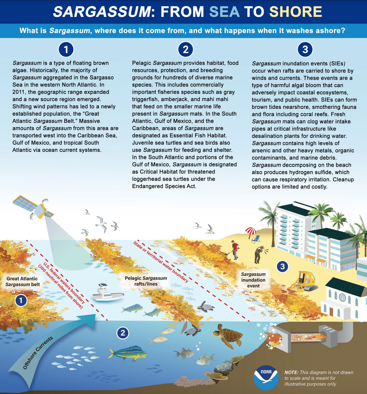
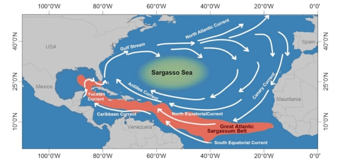
“Pelagic sargassum seaweed is a brown macroalgae floating on the ocean surface,” Xie said. “It was first reported in the 15th century by Christopher Columbus, and a regional sea in the North Atlantic Ocean, the Sargasso Sea, was named after this plant. Sargassum serves as a habitat for many marine animals, such as turtles, fish, shrimp, crabs, and so on. These macroalgae can grow to a length of several meters and form floating mats on the ocean surface,” Xie continued.
Health Impacts
Sargassum has positive and negative benefits for the environment. In most cases, moderate amounts on beaches do not pose a significant risk to people, but there are important exceptions.
“Most of the time, moderate amounts on beaches would not represent a risk factor for humans. However, there are exceptions,” cautioned Xie. “After a couple of days onshore, sargassum starts to decompose and release noxious and stinking gases such as ammonia and hydrogen sulfide. The bad smell can cause respiratory problems. There are reports that in some of the Caribbean Islands, the hospitalization rate has gone up during the sargassum season,” he said.
“Sargassum can be both good and bad for the environment. In the ocean it is a critical habitat for many animals, so they should like to see increased sargassum. Sargassum on beaches can also stabilize sand dunes, thus helping to avoid beach erosion. But too much of a good thing can also make it bad. Excessive amounts of sargassum can also cause environmental and economic problems,” Xie added.
“There is no scientific consensus on exactly what caused the sargassum increases in the past decade in the Atlantic Ocean, but climate change may be part of the reason, as it affects precipitation, ocean circulation, and dust events, among other factors. This is still a research topic,” according to Xie. The current predictions for a busy year of sargassum are based on statistical models rather than the exact causes of why the amount of seaweed is expected to increase.
Sargassum Outlook: Additional Increases Expected
Sargassum amounts are expected to increase across most regions in the coming months, according to USF.
“Sargassum amount in most regions is set to increase in the coming month,” USF predicted. “The western Caribbean and the windward side of the Lesser Antilles will continue to see beaching events. Sargassum amount in the Gulf will remain low.
“Because of the continuous growth from November to February and the record high sargassum amount in most regions, 2026 is set to be another major sargassum year, including sargassum amounts exceeding 75% of the historical values,” USF added.
Follow Sargassum Updates and the Weather Forecast
Individuals can follow the progression of the current sargassum mats and stay up to date each month on where seaweed may be headed.
Finally, in addition to tracking sargassum conditions, residents and visitors across the U.S. Virgin Islands are encouraged to continue monitoring the local weather forecast.
Weather information is available from the National Weather Service and the National Oceanic and Atmospheric Administration. The local weather forecast for the U.S. Virgin Islands is regularly updated on the Source Weather Page, and individuals can also find weather alerts and preparedness information from the Virgin Islands Territorial Emergency Management Agency.