Editor’s Note: This is part 3 in the series, Sacred Geography, Ancestral Memory & the Restoration of Meaning, which explores the natural and cultural history of the recently designated Maroon Sanctuary Territorial Park in northwest St. Croix. Previous articles in the series can be found here, and here.
“The Maroon Sanctuary Park should be a place where we confront the brutalities of our past while celebrating the unbroken spirit of those who resisted it. It should teach future generations that freedom was neither given nor abstract; it was fought for on this very soil. The park must speak to that defiance and that dignity”
— Former Sen. Janelle K. Sarauw
“The people who made Maroon Country their sanctuary and stood for freedom and human dignity have names and identities. They are part of the ancestral history of St. Croix and are connected to the people alive on St. Croix today.”
— Olasee Davis
“The African eagle can fly only with his re-membered wings.”
— Ngũgĩ wa Thiong’o (Decolonizing the Mind)
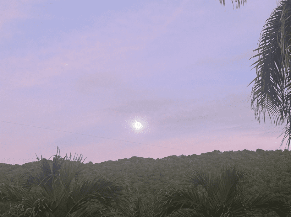
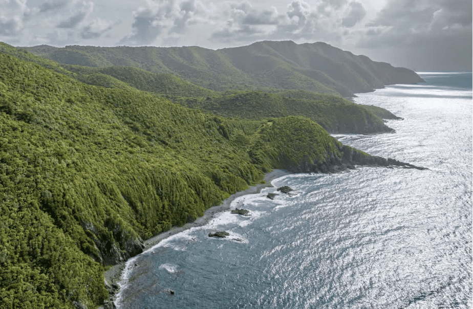
A nearly full moon is poised above the hills of Maroon Country in the cool of dawn as the morning sky inhales early light, gradually becoming flushed with lavender hues. A primordial hush spreads over the verdant landscape like a benediction. The territory that I look out over, that of the newly designated Maroon Sanctuary Territorial Park, contains within its borders an embarrassment of riches: From the marine ecosystems along its pristine coastline, teeming with a diverse abundance of living organisms, to the sun-dappled floor of virgin forest where native plants and animals pursue their destinies unmolested by wanton development; this wild region of northwestern St. Croix carries echoes of an elemental paradise.
High up on Maroon Ridge one’s field of vision is often dominated by the prospect of serried rows of forested bluffs that plunge precipitously toward roiling emerald waters along the rocky shore. The grandeur of this landscape on this tiny island in the West Indies invites comparisons to some of the most sublime places I’ve ever encountered in my travels: whether on safari in the grasslands of equatorial East Africa, conducting field work as a graduate student in the magisterial wilderness of Alaska or Yellowstone Park, writing about traditional culture in the mist-shrouded Iya Valley of Shikoku Island (the “Tibet of Japan”), sojourning in the hills north of Chiang Mai, Thailand, vacationing on the Amalfi Coast of Italy, hiking in the volcanic rainforests of Hawaii, or walking in the terraced rice paddies and foothills of Bali, Indonesia. Standing in the hush of dawn and looking out over the transcendent beauty of Maroon Country, a sense of mysterium tremendum can ensue, as though one were witnessing the earth in its first morning.
And yet the temptation to regard Maroon Country as a kind of prelapsarian Eden begins to falter and finally unravels when one considers the brutal inhumanity from which escaping African slaves, “Maroons,” once fled in order to take up refuge here in this region’s dense forest, among its rocky crags, steep cliffs and hidden caves. The human stories that are etched into this landscape are narratives of desperation, tales of defiance. This is a fugitive geography, a topography of resistance.
The pervasive sense of equanimity that seems to emanate from the landscape on this cool morning belies its fractured and haunted past. Seen from the contextualized perspective of history, the bitter realities of the Danish West Indian colonial project quickly swim into focus, casting a looming shadow over a landscape that otherwise seduces the hapless visitor with a kind of mythic beauty. For if some halcyon era did once exist sometime in the misty past when this region could reasonably have been described as having truly possessed “Edenic” qualities, certainly the Danish colonial project, like all imperial endeavors, may be said to have contained within it the seeds of a proverbial Fall from Grace. To take the full measure of the splendour of this place will require an honest acknowledgement of, and some kind of reckoning with, its haunted past.

After purchasing St. Croix from the French in 1733, the Danish promptly launched an economy that was predicated upon readily available slave labor and a sugarcane monoculture that violently wrested wealth from the earth just as it deprived the soil of precious water. The historic mansions one can see today in Copenhagen, with their gilded facades and ornate ironwork, were constructed largely with the profits made from the Danish colonial sugar empire in the Caribbean. The grinding gears of that colonial economy involved a malevolent pairing of the brutality of enslaved labor with an aggressive, short-sighted and unsustainable agricultural practice that left in its wake an island denuded of forest cover, its soils parched, its shorelines eroded and its coral reefs reeling from mining for colonial building materials. St. Croix suffered precisely the kind of dismal litany of ecological degradation that predictably follows in the wake of the imperial pursuit of short-sighted and short-term economic gain. While Maroon Country appears to the naked eye as utterly pristine and unspoiled, it is, in fact, a landscape in recovery, scarred by environmental abuse and haunted by the memory of human enslavement.
With the recent designation of this region as a sanctuary, a living monument honoring the legacy of the irrepressible spirit of the Maroons, a new hope is born. For the territorial park to live up to its promise, though, will require shining a bright light into its past, excavating its stories of defiance, remapping its geography and reclaiming its place in history as a refuge for self-emancipated Africans. This, in turn, will require a sustained inquiry into, and a concerted exploration of, the mysteries that continue to abide here. It will mean asking some fundamental questions: Who were the Maroons? From what deep source did they draw the courage of their defiance? Where in this shadowed territory did they settle and why? How did they live here?
The consensus among experts seems to be that the nature of Maroon settlement here was ephemeral, not static but dynamic, and shaped perhaps in part by the need to remain concealed, forever poised on the threshold of flight, ready to be on the move should the colonial militia penetrate the dense forest cover in search of fugitives. The material evidence Maroons left behind in the landscape is limited, the physical traces of their settlement are few. They left behind more mystery than they did clarity, more questions than answers.
The professionals who are attempting to answer those questions, to connect the few dots that do exist so that a reasonable facsimile of Maroon life here might be reconstructed, are bringing cutting edge technology and rigorous research to bear upon their pursuit. They are approaching this task with ingenuity, innovation and a profound respect for Maroon life. It is their desire, it seems, to re-map this geography and to weave these stories back into a landscape from which they have been effectively erased.
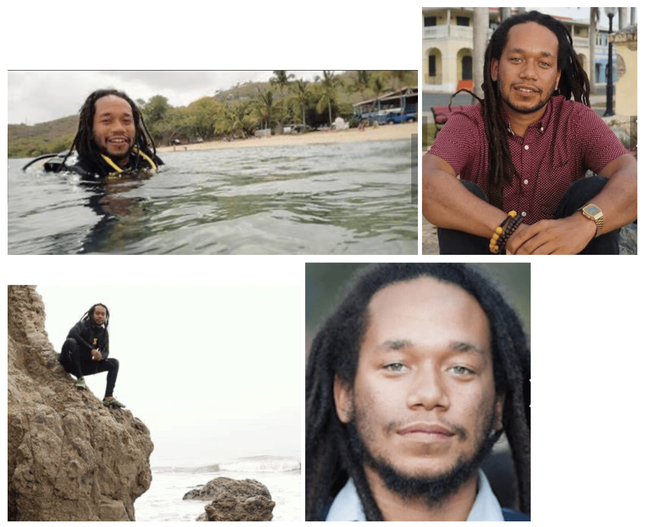
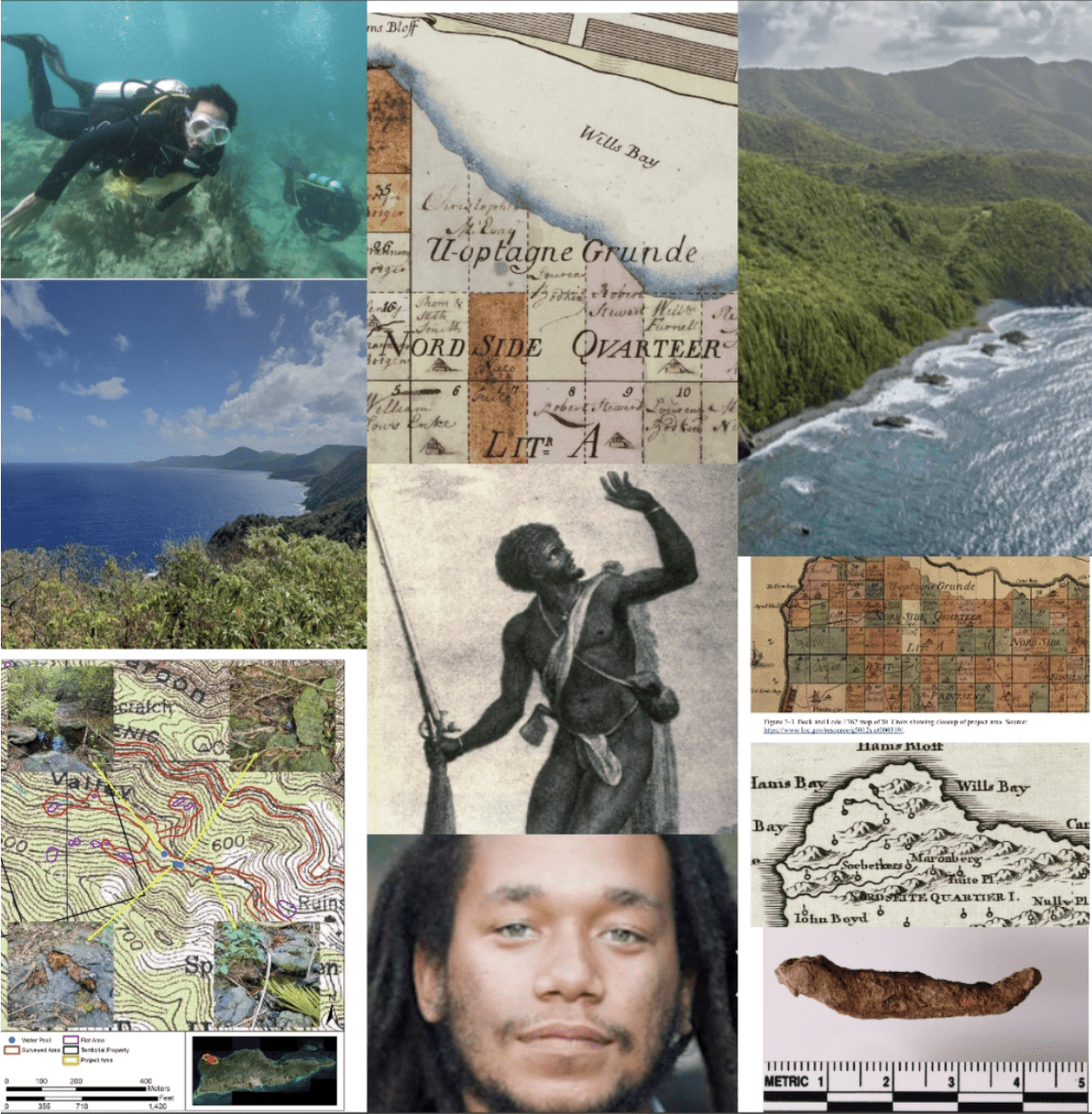
Like so many of us, Dr. Justin Dunnavant first learned of the history of Maroon settlements in northwestern St. Croix from the tireless and inimitable Olasee Davis. Dunnavant, an African diaspora archeologist and assistant professor of anthropology at UCLA, was in the midst of a six-year-long excavation of Estate Little Princess when, in 2016, he went on an eye-opening hike into Maroon Country with the iconic UVI ecologist and historian, Professor Olasee Davis who, for over 40 years, has advocated on behalf of protecting the region as a territorial park.
Dunnavant’s current work, as he explains it, “explores the ecology of slavery and freedom in the U.S. Virgin Islands, specifically on the island of St. Croix, or ‘Ay Ay’, as it is known by its indigenous name.” In his research he is looking specifically at the ways in which the Transatlantic Slave Trade “mediated, created and maintained new ecological relations between people and their environments.” He became interested in these questions while excavating Estate Little Princess with his colleagues from the Society of Black Archaeologists. “I really wanted to see how the historical processes of slavery and the Transatlantic Slave Trade impacted the current ecological and environmental situation.”
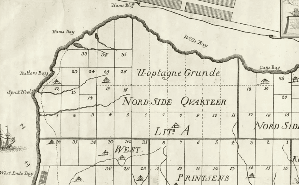
“Part of the work I’m interested in doing,” Dunnavant explains, “is trying to resituate what the Black experience would have been like geographically and temporally.” This process begins with recognizing the ways in which colonial maps committed what some have referred to as “cartographic violence,” or an erasure of Black life from colonial maps. Referring to the iconic Jens Michelsen Beck 1754 Map (see figure above), Dunnavant points out that colonial plantations and land holdings are demarcated with clearly defined linear squares and blocks, but that the “one place where we do find independent, autonomous Black life is listed as ‘uncharted ground’ (‘Uoptagne Grunde’ in Danish). This would have been the site of ‘Maroon Ridge,’ land that was occupied by the Maroon community during the era of enslavement.” In a paper he co-authored with his colleagues Steven A. Wernke at Vanderbilt University and Lauren E. Kohut at Winthrop University entitled Counter-Mapping Maroon Cartographies: GIS and Anticolonial Modeling in St. Croix, Dunnavant (et al) explore the ways in which Maroon landscapes on St. Croix were obscured through colonial cartographic methods and motivations.
In the abstract to Modeling Marronage: GIS Heuristics of Refuge Affordances in Colonial St. Croix, Dunnavant and his colleagues explain that “archival documents reference settlements of runaway enslaved Africans in the mountainous range known as Maroon Ridge. These settlements provide an important record of Afro-Atlantic resistance to enslavement. However, as both intentionally secluded and ephemeral places of refuge, these maroon settlements are difficult to locate in the archaeological record. Geospatial modeling provides one avenue for understanding African geographies of resistance.” The work that Dunnavant and his colleagues are doing in the park entails utilizing this cutting edge Geospatial mapping technology in an attempt to see 300 years into the past. “These geographies were, in many cases, intentionally left opaque and unknowable by the colonial administration.”
When I spoke with Dunnavant via Zoom from his office at UCLA, he explained the process to me: “We got publicly available LiDAR data from the island, essentially high resolution imagery and we used that data to see what the bare earth environment would have looked like — what it would look like if you were to you strip the trees off it. That gave us the basic topography of the island and we could then superimpose two historic maps on top of it. From there we used GIS to digitize the location of colonial buildings based on the records from the historical maps. This enabled us to create a predictive model that helped us answer questions about where Maroons were likely to have settled.”
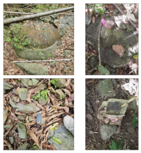
This mapping work and the creation of a GIS-based predictive model enabled Dunnavant and his colleagues to identify these most likely sites for Maroon settlement and habitation. These findings in turn helped guide a 2022 archaeological survey of 33.39 acres within the borders of what is now the new park. Undertaken by the Texas State University’s Center for Archaeological Studies, the survey focused on these high probability areas identified in the predictive model and flat areas identified from the LiDAR data. Six flat areas were surveyed and artifacts were found during metal detecting in three of these. The primary archaeologists who conducted the survey, Todd M. Ahlman and Ashley H. McKeown, believe these locations are likely Maroon habitation sites and they have recommended additional surveys to confirm this supposition.
While steady progress is being made to positively identify Maroon settlements and habitation sites within the new park, Dunnavant agrees that the fact that, even with the sophistication of modern mapping technology, this goal has proven largely elusive, is powerful testament to Maroon cunning and stealth. It seems that, for the moment anyway, the 18th century Maroons have outsmarted all that 21st century technology has at its disposal.
The collective work of re-mapping this geography and coaxing this history out of the shadows and into the light might necessarily entail a certain degree of “Critical Fabulation,” a narrative methodology that blends historical research with speculative storytelling. Critical Fabulation aims to address gaps and omissions in historical records, particularly regarding marginalized voices, by reimagining the past through a critical lens.
In his thinking about this work, Dunnavant cites the influence of the Kenyan writer, literary scholar and post-colonial theorist Ngũgĩ wa Thiong‘o. In his book “Something Torn and New: An African Renaissance,” Thiong’o explores the process of “Re-membering,” which he sees as required for African peoples who have experienced colonization as well as those who were forcefully brought to the Americas. “It’s a re-membering,” Dunnavant explains, “in both the literal and the metaphorical sense. Pulling pieces of the cultural past that have been disarticulated and putting them back together. They may not come back in the same form but it is a process that needs to occur.” Thiong’o believes this process of cultural restoration must begin with mourning and a recognition of what has been lost.
It occurs to me that Thiong’o’s diagnosis and prescription are perhaps relevant and applicable to Maroon Sanctuary Park and to the reclamation of history and the restoration of meaning that it might hope to achieve through the archaeological efforts of Dunnavant himself, the activism, stewardship and teaching of Davis, the art, ethnography and spiritual ministry of Dr. Chenzira Kahina Davis, as well as the cultural heritage preservation work of Frandelle Gerard at CHANT. People whose work promises to help the community to “re-member.” And perhaps the park itself, as a living monument, as a physical touchstone of transcendental natural beauty and spiritual import, might serve the territory both as a profound reminder of its fractured and haunted past and as an opportunity to “re-member” its way into the future. Perhaps the park and what it represents holds the seeds of recovery, the promise of nurturing a kind of collective healing from the psychic wounds of the past so that a restoration of wholeness might someday be possible.
While the designation of Maroon Sanctuary Park seems to pave the way for the these efforts to map the Maroons back into territory they made their own, to unearth their stories and to weave them into the broader fabric of V.I. history, the mystery that the Maroons left behind remains an essential component of their cultural legacy. Could we simultaneously learn all we can about them, have their legacy permeate the curricula of our schools while also preserving, in perpetuity, the integrity of the mystery they left in the wake of their passage through this landscape? Given that their raison-d’être was to remain clandestine, sub rosa, concealed, hidden, it seems appropriate that the puzzle the Maroons left behind should remain intact. That essential mystery should perhaps persist as a kind of animating feature of the landscape itself, infusing the cliffs and rocky outcrops, the deep forested valleys, the hidden caves and the pellucid waters of the tide pools with the ancestral memory of a people who refused to allow the inhumanity of slavery to define them.
— Joshua Grant Canning holds a Master’s Degree in Environmental Journalism and in his writing he pursues projects that involve the intersection of nature and culture. On the basis of his writing about the ecological and cultural implications of the reintroduction of wolves to Yellowstone National Park, he was awarded a Middlebury College Graduate Fellowship in Environmental Journalism 2008-2009. The fellowship enabled him to travel widely in Japan (where he had lived previously for four years) to research and write about pressing environmental and cultural issues. He and his wife, Wendy, moved from Vermont to St. Croix in 2010 and he taught World Literature and AP English at Good Hope Country Day for over a decade. He is also a musician and jazz guitar enthusiast and performs regularly at events and venues around the island.