Tropical Storm Erin is expected to strengthen into a hurricane before passing near the Caribbean this weekend. The National Hurricane Center forecasts a turn north and away from the U.S. Virgin Islands, though the exact timing and track remain somewhat uncertain.
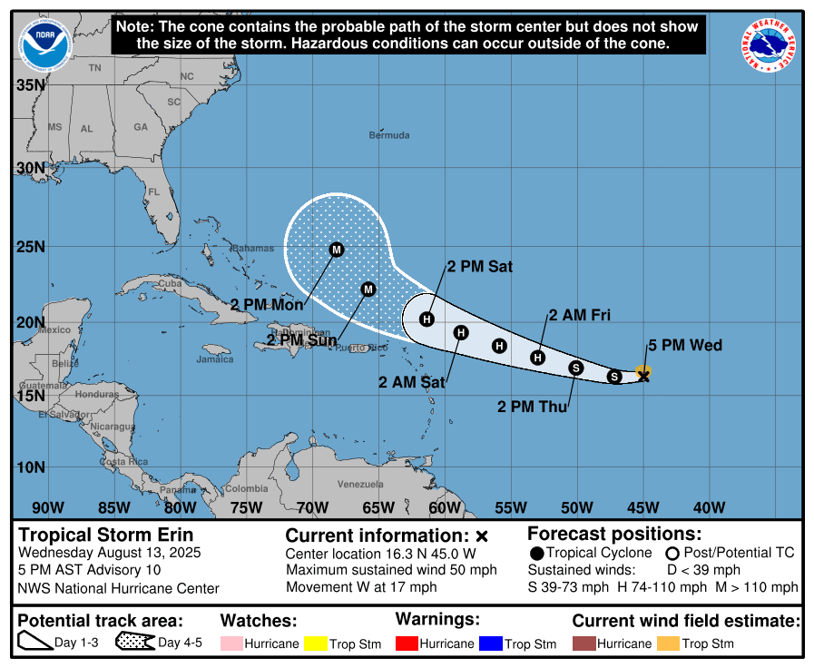
As of the 5 p.m. Wednesday update from the NHC, Erin was located about 1,200 miles east of the northern Leeward Islands, moving generally westward with maximum sustained winds near 50 mph. The system is forecast to reach hurricane strength, with winds of at least 74 mph, by Friday, and could eventually intensify into a major hurricane of Category 3 strength or higher.
The Track of Tropical Storm Erin
As of Wednesday afternoon, the official National Hurricane Center track takes the core of Tropical Storm Erin north of the U.S. Virgin Islands and Puerto Rico, and no tropical alerts have been issued.
“At 5:00 PM AST, the center of Tropical Storm Erin was located near latitude 16.3 North, longitude 45.0 West,” the NHC reported. “Erin is moving toward the west near 17 mph, and this general motion is expected to continue into Thursday, with a west-northwestward motion beginning Thursday night and continuing into the weekend. On the forecast track, the center of Erin is likely to move near or just north of the northern Leeward Islands over the weekend.
Many of the computer forecast models are now in agreement on a turn to the north, but uncertainty remains about the timing, and future forecast adjustments are possible.
Potential Impacts to the USVI and Puerto Rico
While the core of the cyclone may pass north or northeast of the U.S. Virgin Islands and Puerto Rico, the NHC said Wednesday that the region could still experience impacts, including rainfall, gusty winds, and choppy seas.
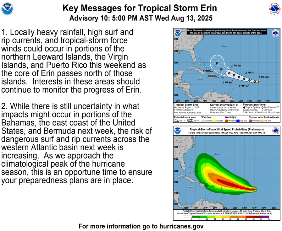
“Locally heavy rainfall, high surf and rip currents, and tropical-storm force winds could occur in portions of the northern Leeward Islands, the Virgin Islands, and Puerto Rico this weekend as the core of Erin passes north of those islands,” the NHC said. “Interests in these areas should continue to monitor the progress of Erin.”
“While there is still uncertainty in what impacts might occur in portions of the Bahamas, the east coast of the United States, and Bermuda next week, the risk of dangerous surf and rip currents across the Western Atlantic basin next week is increasing. As we approach the climatological peak of the hurricane season, this is an opportune time to ensure your preparedness plans are in place,” according to the NHC.
The National Weather Service in San Juan, Puerto Rico, also outlined potential impacts from Erin across the local islands.
“Based on the latest NHC`s trajectory and intensity forecast for Erin, the cyclone’s center should move off to the northeast of the northeastern Caribbean around early Sunday morning,” the NWS explained. “However, Erin’s external rain bands could arrive as early as Saturday morning and most likely around Saturday evening.”
“As Erin follows the NHC track forecast, winds will shift from the south to southwest around Sunday, pooling plenty of tropical moisture over the islands, increasing the potential to observe urban flooding, landslides, and river flooding, as well as mudslides along steep terrains,” the NWS warned.
“The areas where the most active weather will remain possible will be across the U.S. Virgin Islands, as well as the southeastern slopes, the northeast, and the northeast interior portion of Puerto Rico. Keep in mind this is tied to the final behavior of Erin, so the level of uncertainty is still high,” the NWS advised.
The NWS also noted that as Erin approaches, seas are anticipated to become very rough, and the risk of rip currents will increase.
“Erin’s swell action could deteriorate marine and coastal conditions, creating life-threatening rip currents for this upcoming weekend,” the NWS said.
NOAA Global Tropics Hazards Outlook
The potential for more tropical development is possible as we move toward the end of August and into the beginning of September, according to a Global Tropics Hazards Outlook released on Tuesday, Aug. 12. The forecast tool, which is released weekly by the National Oceanic and Atmospheric Administration’s Climate Prediction Center, offers insight into potential developments across tropical basins up to three weeks in advance.
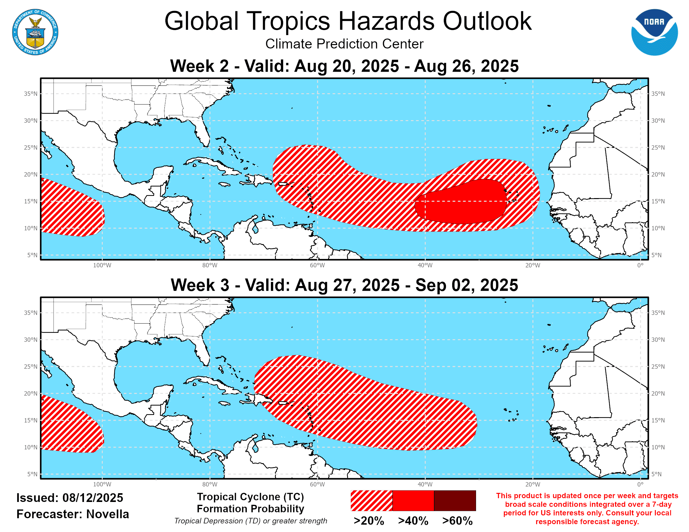
In its latest update, NOAA highlighted areas across portions of the Caribbean as well as within the Main Development Region — the zone between the west coast of Africa and the Caribbean — as having increased chances for tropical activity in the coming weeks. The Eastern Pacific basin, which has been active in recent weeks, is also expected to maintain an elevated opportunity for cyclonic development.
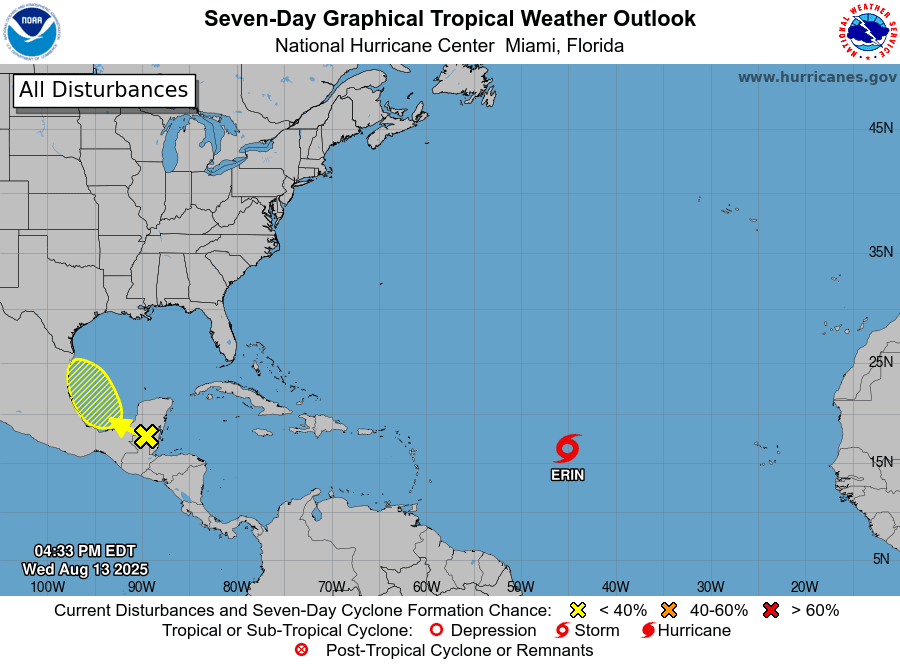
“In the wake of Erin, multiple areas of low pressure, known as tropical waves, will be monitored for the development of additional storms,” according to an update from AccuWeather on Wednesday. “Additionally, a cluster of thunderstorms in the southwestern Caribbean could quickly ramp up into a tropical depression or storm as it travels over the southwestern Gulf of Mexico in the next day or two,” AccuWeather reported.
As of Wednesday afternoon, in addition to Erin, the NHC was monitoring a tropical wave located near the southwestern Gulf with a low chance of development over the next seven days.
VITEMA Provides Update on Tropical Storm Erin
In other weather-related news, Daryl Jaschen, director of the Virgin Islands Territorial Emergency Management Agency, held a press briefing Wednesday on Tropical Storm Erin. He assured residents that VITEMA is coordinating with agencies, including the NWS and FEMA, in preparation for any possible impacts. While no tropical weather alerts were in effect as of Wednesday, Jaschen encouraged residents to sign up for emergency notifications in case watches or warnings are issued.
Jaschen also shared information on Wednesday that sandbags will be distributed across the territory beginning Thursday, Aug. 14. Originally planned for later this month, the distribution was moved up due to uncertainty surrounding Tropical Storm Erin. VITEMA noted this will be the only sandbag distribution for the 2025 Atlantic hurricane season.

“Due to the projected impact of Tropical Storm Erin on the U.S. Virgin Islands, VITEMA, in partnership with the Virgin Islands Fire and Emergency Services, the Department of Public Works, the Office of ADA Coordinator, and the Department of Human Services, has accelerated the territory-wide sandbag distribution program,” according to a VITEMA press release on Wednesday.
Locations for sandbag distribution were provided in the press release:
Sandbag Distribution Information
Dates and Times
- Fire Stations: Aug. 14, 15, and 16 from 8 a.m. – 3 p.m.
- DPW Sites: Aug. 14 and 15 from 8 a.m. – 4 p.m. (lunch break 12:00–1 p.m.)
- Bring: ID and your own shovel
Access and Functional Needs; Aging Community Who Require Sandbag Delivery
- Call-in dates: Aug. 11–14 (9 a.m. – 3 p.m.)
- Sandbag delivery: Aug. 18–19
- Croix: 340-718-2980
- Thomas/St. John: 340-473-1848 or 340-998-3571
Water Island
- 6 – 8:30 a.m.: Sandbags will be available at Barge Dock (DPW)
- Due to short notice, Water Island distribution cannot occur before the storm’s arrival. Residents are encouraged to obtain sandbags from St. Thomas or St. John during the general distribution period.
Locations:
- St. Croix: Estate Anna’s Hope DPW, Concordia DPW, Cotton Valley Fire Station, Grove Station Fire Station
- St. Thomas: Sub Base DPW, Fortuna Fire Station, Tutu Fire Station, Omar Brown Fire Station
- St. John: Susannaberg DPW, Coral Bay Fire Station
Individuals can find more information about sandbag distribution on VITEMA’s official website.
Jaschen explained that if a curfew is imposed due to Tropical Storm Erin, individuals will need a curfew pass to travel outside of designated hours. Passes are available only to residents who have previously submitted applications and can be collected from VITEMA offices on St. Thomas and St. Croix. He added that those requiring access to dialysis services will be permitted to travel regardless, and dialysis centers are expected to remain open.
Local Weather Updates
In addition to Tropical Storm Erin, the NWS continues to remind residents to remain as cool, as very warm temperatures are expected to continue, which can result in heat-related illnesses. Hazy conditions due to Saharan dust are expected to persist through Thursday.
It is crucial to remember that the forecast can change very quickly. USVI residents and visitors are encouraged to continue to remain prepared. Weather information is available from the NWS, the NHC, and NOAA.
“The NHC track forecast has an average error of 150 to 215 statute miles at four and five days in the future, so we expect future adjustments to the forecast,” the NWS stated. “Thus, we encourage everyone in Puerto Rico and the U.S. Virgin Islands to keep an eye on Erin over the next few days, as the intensity and track forecast will undergo changes, and our weather conditions depend on its progress,” the NWS advised.
The local weather forecast for the U.S. Virgin Islands is regularly updated on the Source Weather Page and VI Source YouTube Channel. A weekly Tropical Outlook article from the Source is also published throughout hurricane season to provide in-depth updates.
Additionally, residents and visitors can find weather details and preparedness information from VITEMA.