
The National Hurricane Center is monitoring Tropical Storm Lorenzo, located in the central Atlantic and well away from land. Meanwhile, a tropical wave emerging off the West African coast could gradually develop.
Tropical Storm Lorenzo
Tropical Storm Lorenzo remains over open water in the Central Atlantic, far from land, with no coastal warnings currently in effect. Some satellite imagery suggests the storm is poorly organized, and its track is forecast to gradually shift northward and then northeastward over the next few days.
As of Tuesday evening, the cyclone was located about 1430 miles west of the Cabo Verde Islands off the coast of Africa. The storm was moving toward the northwest and packing winds of approximately 40 mph.
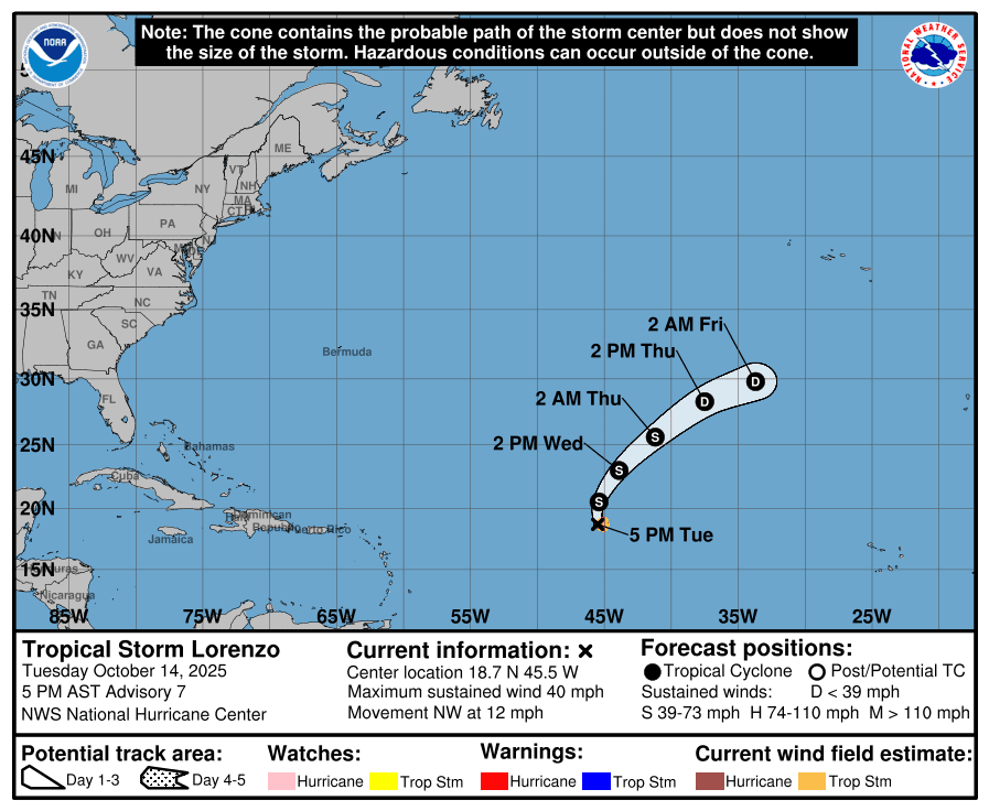
“At 5:00 p.m. AST, the center of Tropical Storm Lorenzo was located near latitude 18.7 North, longitude 45.5 West,” according to an update from the National Hurricane Center on Tuesday evening. “Lorenzo is moving toward the northwest near 12 mph (19 km/h). A turn to the north is expected tonight, followed by a northeastward motion on Wednesday and Thursday. Maximum sustained winds have decreased to near 40 mph with higher gusts. Continued weakening is expected, and Lorenzo is forecast to dissipate within a few days,” the NHC added.
New Tropical Wave Emerges Off West African Coast
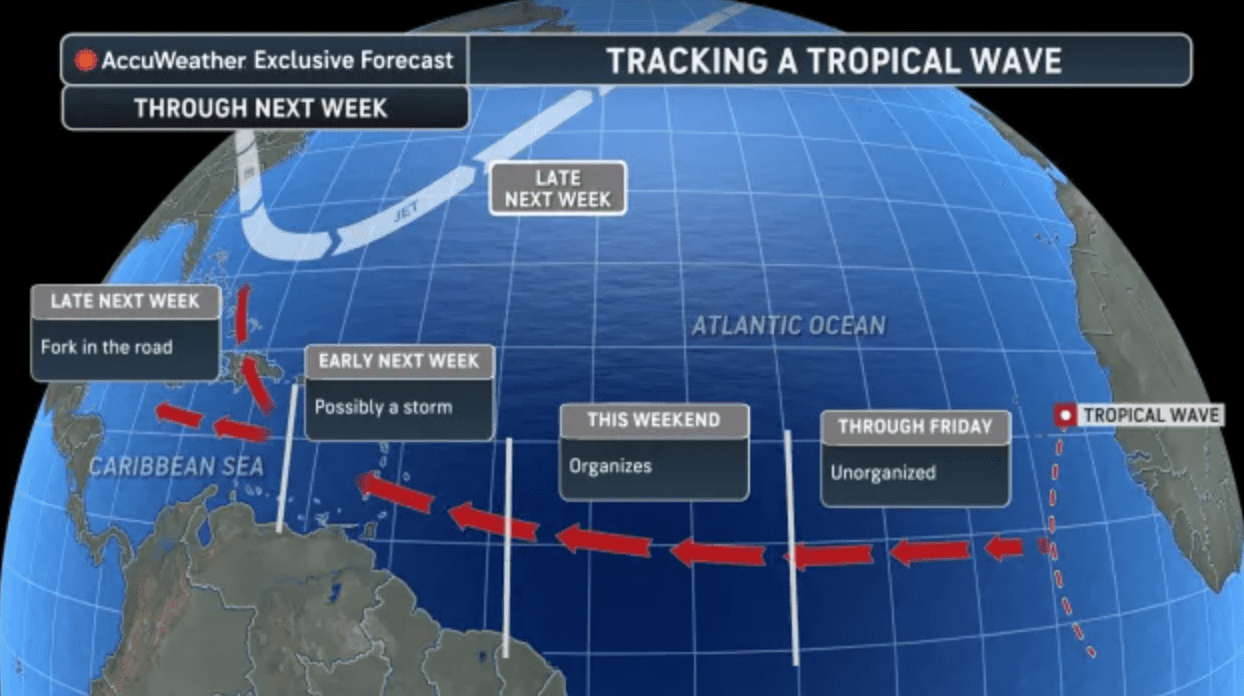
Meanwhile, a tropical wave that recently moved off the West African coast may develop in the coming days. It is too soon to determine whether the system could affect the U.S. Virgin Islands or Puerto Rico, but it is expected to move through generally favorable conditions that could support gradual organization.
On Tuesday morning, AccuWeather released information about Tropical Storm Lorenzo and also shared information about the newly emerged tropical wave off the coast of Africa.
“A plethora of warm waters in the southern Atlantic and lesser disruptive winds, called wind shear, all mean it is possible the wave could reach tropical storm status by the time it reaches the Caribbean islands,” according to the AccuWeather article.
“The next name on the Atlantic basin list is Melissa, but the fate of this tropical wave once it reaches the Caribbean Sea remains even less certain. The weather pattern late next week could pull the storm north toward the Bahamas and the United States. However, it could also continue moving west across the abnormally warm Caribbean,” AccuWeather said.
Hurricane Expert Insight
The Source reached out to Alex DaSilva, AccuWeather’s lead hurricane expert, to learn more about potential tropical weather threats in the coming days.
“The next system we’re monitoring has just come off the coast of Africa, and it’s extremely far south, around 10 degrees north latitude, and farther south than any of the waves that we’ve seen this season,” DaSilva said. “Because of that position near the equator, it’s harder for the system to develop right away, due to there being less of an influence of the ‘Coriolis effect,’ which is what allows storms to spin and organize,” DaSilva continued.
“The wave looks fairly healthy but probably won’t strengthen much in the short term,” DaSilva noted. “As it moves westward later this week and into early next week, it’s expected to lift slightly northward, which could give it a better chance to develop. What’s interesting about this wave is that it may be able to stay south of the strong wind shear and dry air that have been limiting other systems farther north. That gives it a better opportunity to hold together as it approaches the Lesser Antilles late this weekend or early next week, around Sunday or Monday.”
DaSilva said that as of Tuesday, forecast models indicate the tropical disturbance may pass south of the U.S. Virgin Islands. However, he cautioned that this outcome is not guaranteed.
“The system could organize enough to become a tropical storm, though we don’t expect anything particularly strong near the islands at that time. Current indications show the system tracking south of the Virgin Islands, but we can’t completely rule out an impact there. If a dip in the jet stream develops along the East Coast, it could pull the system farther north, so we’ll need to keep monitoring closely,” DaSilva stated.
“If the wave ultimately reaches the western Caribbean, conditions become much more favorable for development. Wind shear drops off and ocean heat content is extremely high, because no storms have passed through that area this season. If it survives that long, it could strengthen rapidly, so it’s something we’ll be watching carefully,” DaSilva emphasized.
The Atlantic hurricane season continues for about six more weeks, officially ending Nov. 30. DaSilva noted that there is still time for tropical development to occur, including systems that could organize and potentially affect the local islands. However, based on climatology, the risk of tropical cyclone impacts across the Northeastern Caribbean typically decreases after mid-October.
“The new wave came off Africa around Oct. 14, which lines up with when we typically see the last few viable waves of the season,” DaSilva confirmed. “Historically, very few storms develop east of the islands after Oct. 20, so this could be the last African wave worth serious monitoring,” he said.
“We may still see a few more waves emerge from Africa through the end of the month, but most will likely struggle to survive the trip across the Atlantic. At this point, this one appears to be the main feature to watch. Right now, there’s nothing immediately behind it that looks like a strong development candidate,” DaSilva added.
La Niña Weather Pattern Officially Develops
As forecasters monitor Lorenzo and the newly formed tropical wave, broader climate conditions are also shifting in a way that could influence the remainder of hurricane season.
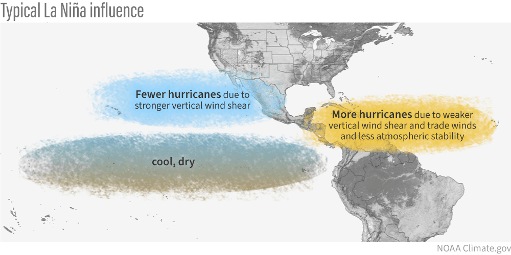
On Oct. 9, NOAA reported that a La Niña weather pattern has developed. During a La Niña cycle, the ocean waters across the equatorial Pacific Ocean cool significantly, affecting global weather. During La Niña, wind shear — a change in wind direction and velocity with height in the atmosphere — also typically decreases in the Atlantic Ocean. A reduction in wind shear can favor cyclone development. This pattern is the opposite of “El Niño,” a warming of the equatorial Pacific, which usually increases wind shear in the Atlantic Ocean, helping to rip apart storms and prevent hurricane formation and intensification.
“Scientists call the two opposing climate patterns of El Niño and La Niña the ‘El Niño-Southern Oscillation’ cycle. El Niño and La Niña can both have global impacts on weather, wildfires, ecosystems, and economies,” according to NOAA.
With La Niña now in place, forecasters note that conditions could remain favorable for additional tropical development through the remainder of the Atlantic hurricane season, which officially ends on Nov. 30.
“La Niña conditions have now officially developed, which we’ve been expecting, and that can reduce wind shear across parts of the Atlantic basin and promote more tropical development,” DaSilva explained.
“Last year, under similar conditions, we saw three named storms in November, including one hurricane. I don’t necessarily expect three again this year, but two named storms in November are certainly possible. Historically, late-season systems form closer to the U.S. mainland, in the Western Caribbean, or far out in the Atlantic,” DaSilva noted.
“Currently, a pulse of the Madden-Julian Oscillation, which is essentially a large-scale area of rising air that promotes storm development, is moving through, which could help spark some short-term activity. After this wave crosses, things might quiet down for a week or two, but we could see another uptick in November,” DaSilva said.
“Overall, we’re keeping a close watch on this new tropical wave. If it maintains organization into the Western Caribbean, it could become a significant system. It’s too early to say who might be affected. Still, this is definitely one to monitor closely over the next couple of weeks,” DaSilva concluded.
NOAA Global Tropics Hazards Outlook
According to a Global Tropics Hazards Outlook released Tuesday, Oct. 7, there will continue to be an elevated chance of cyclonic development across portions of the Atlantic basin in the coming weeks. The forecast tool, which is issued every Tuesday by the NOAA’s Climate Prediction Center, provides insight into potential activity across tropical basins up to three weeks in advance.
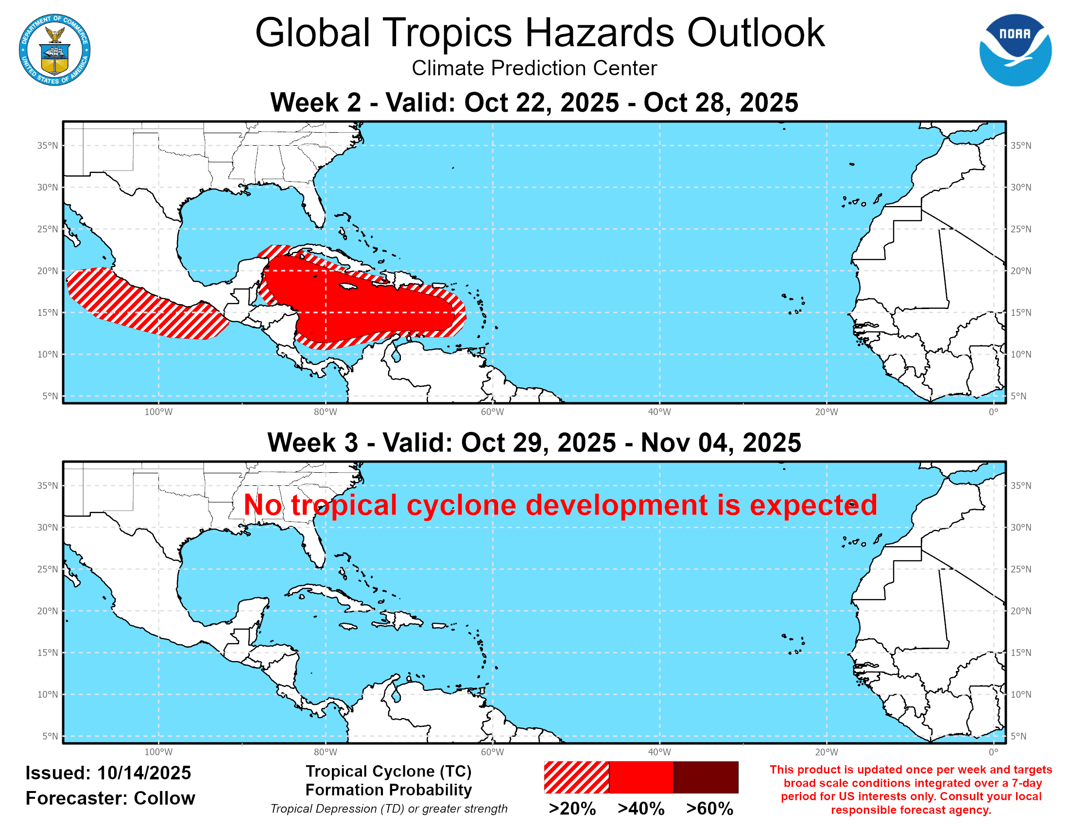
In its latest update, NOAA said that areas across the Caribbean may experience up to a 40-60% chance of tropical development during the “Week Two” outlook period, which runs from Oct. 22 until Oct. 28. Development is not forecast across the Atlantic basin during the “Week Three” outlook, running from Oct. 29 through Nov 4.
Additionally, the Eastern Pacific basin is also expected to experience an increased risk for tropical cyclogenesis during the “Week Two” outlook period.
Local Weather and Staying Informed
Finally, the National Weather Service in San Juan, Puerto Rico, has reminded residents and visitors of local weather-related threats across Puerto Rico and the U.S. Virgin Islands. A shift in the weather pattern is forecast to create the potential for rainfall and thunderstorms with frequent lightning across the islands, particularly during the second half of the week. Very warm temperatures will also continue to affect the region and could prompt continued heat alerts.
Additionally, the NWS has warned that marine conditions are expected to become hazardous as a powerful northerly swell approaches the islands this weekend and into next week.
For mainland visitors in the USVI from areas along the U.S. East Coast: Expect possible travel disruptions after a powerful coastal storm brought flooding rain, damaging winds, and dangerous surf from the Carolinas to New England. According to AccuWeather, the nor’easter caused widespread power outages, coastal flooding, and state-of-emergency declarations in several regions.
The forecast can change quickly, and USVI residents and visitors are encouraged to continue to remain prepared. Weather information is available from the NWS, the NHC, and NOAA.
The local weather forecast for the U.S. Virgin Islands is also regularly updated on the Source Weather Page and VI Source YouTube Channel. Additionally, A weekly Tropical Outlook article from the Source will be published throughout hurricane season to provide in-depth updates.
Residents and visitors can find additional weather alerts and preparedness information from the Virgin Islands Territorial Emergency Management Agency.