Tropical Storm Erin is forecast to become a hurricane by Friday as it nears the northern Leeward Islands, prompting Tropical Storm Watches for several islands. While the latest National Hurricane Center forecast keeps its core just north of the U.S. Virgin Islands and Puerto Rico, forecasters warn the track remains uncertain, and the region could still face heavy rain, gusty winds, and dangerous swells.
Tropical Storm Erin’s Track
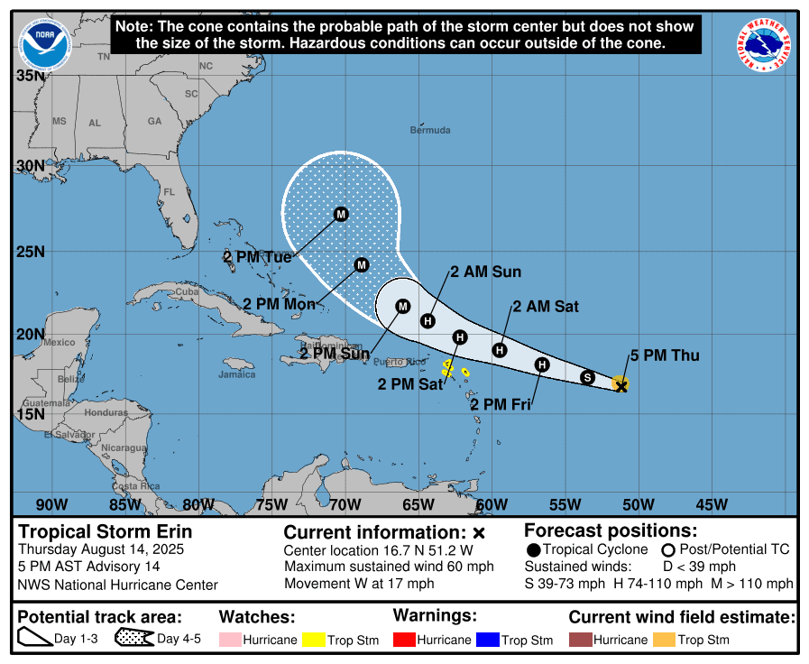
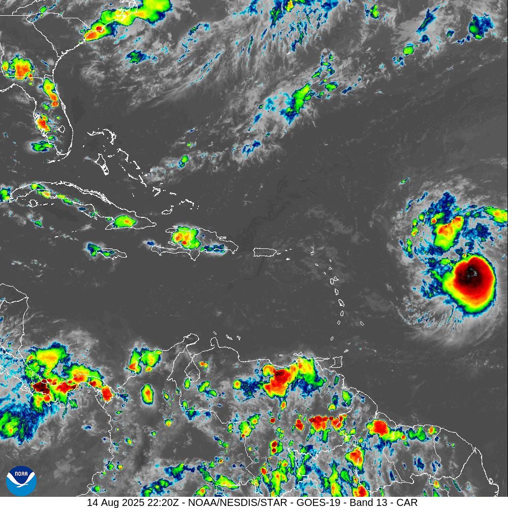
As of the 5 p.m. Thursday update from the NHC, Erin was located about 790 miles east of the northern Leeward Islands, moving westward at 17 mph and with maximum sustained winds of 60 mph. The system is intensifying, and it is forecast to reach hurricane strength, with winds of at least 74 mph, by Friday, and could eventually intensify into a major hurricane of Category 3 strength or higher. Rapid intensification of the cyclone is possible.
“Erin is moving toward the west near 17 mph, and a turn toward the west-northwest is expected tonight, with this motion expected to continue into the weekend,” the NHC said. “On the forecast track, the center of Erin is likely to move near or just north of the northern Leeward Islands over the weekend.”
The NHC’s 5 p.m. updated track continues to take Erin’s core north of the U.S. Virgin Islands and Puerto Rico this weekend. However, the forecast shifted slightly south through 72 hours and west on days four and five. This adjustment highlights continued uncertainty in the exact path, and further changes are possible.
While many of the forecast models still show the system passing just north of the islands, the timing and sharpness of an eventual turn to the north-northwest will significantly influence any potential local impacts.
Tropical Storm Watch Issued for Several Leeward Islands
During its 5 p.m. update, the NHC announced that a Tropical Storm Watch has been issued for several of the northern Leeward Islands, including Anguilla and Barbuda, St. Martin and St. Barthelemy, Saba and St. Eustatius, and Sint Maarten.
The U.S. Virgin Islands, the British Virgin Islands, and Puerto Rico have not received tropical weather alerts as of 5 p.m. on Thursday. However, the NHC stressed that additional watches may soon be issued.
“Tropical storm conditions are possible for portions of the northern Leeward Islands, where Tropical Storm Watches are in effect beginning on Saturday as the core of Erin passes north of those islands,” the NHC reported. “Tropical storm conditions could also occur in portions of the Virgin Islands and Puerto Rico later in the weekend, and additional watches may be required on Thursday night or on Friday,” the NHC added.
According to information from the NHC, a Tropical Storm Watch means tropical storm conditions with winds of 39 to 73 mph are possible within 48 hours, while a Tropical Storm Warning means those conditions are expected within 36 hours. A Hurricane Watch signals hurricane conditions with winds of 74 mph or higher are possible within 48 hours, and a Hurricane Warning means those conditions are expected within 36 hours.
Potential Impacts to the USVI and Puerto Rico
While the core of the cyclone may pass north or northeast of the U.S. Virgin Islands and Puerto Rico, the NHC said Thursday that Erin could still pass close enough to bring impacts to the local islands, including rainfall, gusty winds, and powerful ocean swells.
“Tropical Storm Erin is expected to produce areas of heavy rainfall beginning late Friday and continuing through the weekend across the northernmost Leeward Islands, the U.S. and British Virgin Islands, as well as southern and eastern Puerto Rico,” the NHC warned. “Rainfall totals of two to four inches, with isolated totals of six inches, are expected. This rainfall may lead to isolated flash and urban flooding, along with landslides or mudslides,” the NHC continued.
“Swells generated by Erin will begin affecting portions of the northern Leeward Islands, the Virgin Islands and Puerto Rico by this weekend, and these swells are likely to cause life-threatening surf and rip current conditions. Please consult products from your local weather forecast office,” the NHC said.
The NHC added that tropical storm force winds may occur by early Saturday across the areas currently under a Tropical Storm Watch.
“While there is still uncertainty in what impacts might occur in portions of the Bahamas, the east coast of the United States, and Bermuda next week, the risk of dangerous surf and rip currents across the Western Atlantic basin next week is increasing,” the NHC added.
National Weather Service Information
The National Weather Service in San Juan, Puerto Rico, shared the following information regarding potential impacts from Erin.
“Based on the latest NHC`s trajectory and intensity forecast for Erin, its center should move off to the northeast of the Northeast Caribbean around early Sunday morning,” according to an update on Thursday from the NWS. “However, if this forecast validates, Erin`s external rain bands could turn more frequent as Erin approaches the islands from a distance. Nevertheless, the proximity of Erin will shift from the south to the southwest around Sunday, pooling plenty of tropical moisture over the islands through Monday.”
“Due to continuous shower activity and saturated soils, the potential to observe urban flooding, landslides along steep terrains, and river flooding will increase,” the NWS added.
The NWS also urged caution regarding hazardous marine conditions.
“Erin’s swell action could deteriorate marine and coastal conditions, creating life-threatening rip currents for this upcoming weekend. Residents and visitors are urged to avoid the coastal areas from Saturday afternoon through Monday,” the NWS said.
VITEMA Director Shares Update on Tropical Storm Erin
Daryl Jaschen, director of the Virgin Islands Territorial Emergency Management Agency, held a press briefing Thursday on Tropical Storm Erin. He said he has been in close contact with the National Weather Service in San Juan, Puerto Rico, regarding potential threats the U.S. Virgin Islands could face as Erin passes near the region.
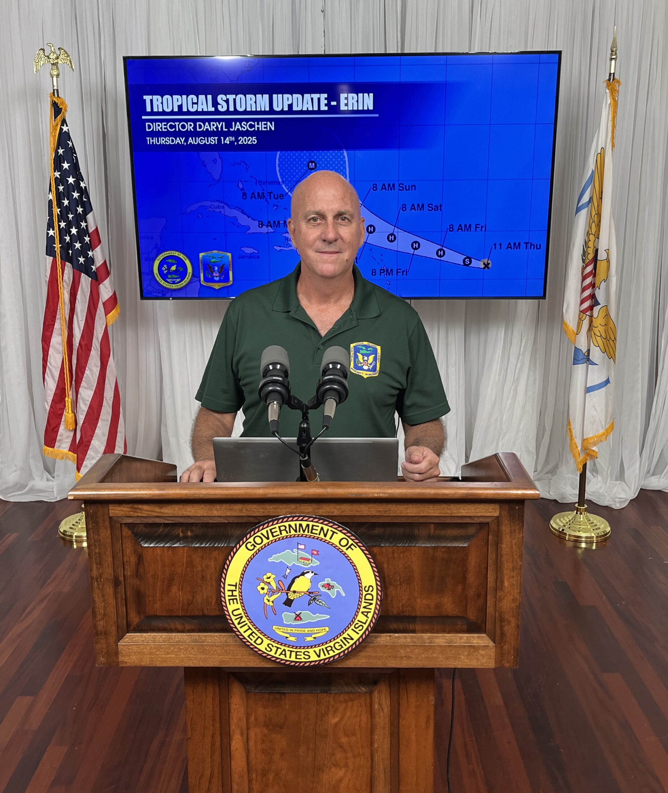
Jaschen confirmed that rainfall totals could reach three to four inches, with showers beginning Friday and intermittent precipitation from Erin’s outer rainbands lasting several days. He added that powerful ocean swells could build to between eight and 12 feet.
Jaschen encouraged residents to sign up for VITEMA’s emergency notifications in the event that storm watches or warnings are announced.
Information was also provided about “Operation Blue Skies,” a sandbag distribution operation across the territory that began on Thursday. Originally planned for later this month, the distribution was moved up due to uncertainty surrounding Tropical Storm Erin. VITEMA noted this will be the only sandbag distribution for the 2025 Atlantic hurricane season.
Locations for sandbag distribution were provided in a press release:
Sandbag Distribution Information
Dates and Times
- Fire Stations: Aug. 14, 15, and 16 from 8 a.m. – 3 p.m.
- DPW Sites: Aug. 14 and 15 from 8 a.m. – 4 p.m. (lunch break 12:00–1 p.m.)
- Bring: ID and your own shovel
Access and Functional Needs; Aging Community Who Require Sandbag Delivery
- Call-in dates: Aug. 11–14 (9 a.m. – 3 p.m.)
- Sandbag delivery: Aug. 18–19
- Croix: 340-718-2980
- Thomas/St. John: 340-473-1848 or 340-998-3571
Water Island
- 6 – 8:30 a.m.: Sandbags will be available at Barge Dock (DPW)
- Due to short notice, Water Island distribution cannot occur before the storm’s arrival. Residents are encouraged to obtain sandbags from St. Thomas or St. John during the general distribution period.
Locations:
- St. Croix: Estate Anna’s Hope DPW, Concordia DPW, Cotton Valley Fire Station, Grove Station Fire Station
- St. Thomas: Sub Base DPW, Fortuna Fire Station, Tutu Fire Station, Omar Brown Fire Station
- St. John: Susannaberg DPW, Coral Bay Fire Station
Individuals can find more information about sandbag distribution on VITEMA’s official website.
Additionally, Jaschen reminded residents that if a curfew needs to be imposed due to Tropical Storm Erin, individuals will need a curfew pass to travel outside of designated hours. Passes are available only to residents who have previously submitted applications and can be collected from VITEMA offices on St. Thomas and St. Croix. He added that those requiring access to dialysis services will be permitted to travel regardless, and dialysis centers are expected to remain open.
Jaschen added that the territory is ready to open emergency shelters if needed, with details on shelter locations to be announced once they are determined.
Finally, Jaschen said that as of Thursday afternoon, schools and government offices are scheduled to be open on Friday. Any changes will likely be announced by tomorrow.
Local Weather Updates
It is crucial to remember that the forecast can change very quickly. USVI residents and visitors are encouraged to continue to remain prepared. Weather information is available from the NWS, the NHC, and NOAA.
The local weather forecast for the U.S. Virgin Islands is regularly updated on the Source Weather Page and VI Source YouTube Channel. A weekly Tropical Outlook article from the Source is also published throughout hurricane season to provide in-depth updates.
Additionally, residents and visitors can find weather details and preparedness information from VITEMA.