Tuesday, 9:30 a.m.
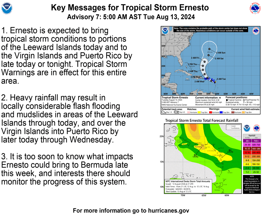
An 8 a.m. update from the National Hurricane Center on Tuesday reports that Tropical Storm Ernesto has slightly intensified as it moves toward the U.S. Virgin Islands and Puerto Rico. The system is forecast to pass across or near the local islands later Tuesday night.
Tropical Storm Ernesto was located about 300 miles east-southeast of San Juan, Puerto Rico Tuesday morning. The cyclone is moving toward the west at approximately 18 mph and is now packing maximum sustained winds of approximately 45 mph.
“On the forecast track, Ernesto is expected to move across portions of the Leeward Islands this morning and near or over the U.S. and British Virgin Islands and Puerto Rico by this evening,” according to the NHC update. “After passing Puerto Rico and the Virgin Islands, Ernesto is forecast to turn northward over the western Atlantic,” the NHC said.
Ernesto may experience some additional strengthening as it continues moving toward the local islands.
“Ernesto is forecast to be in an environment of light to moderate [windshear] and [it will be] over warm sea surface temperatures through the forecast period,” the NHC said early on Tuesday morning. “This combination should allow it to strengthen,” the NHC cautioned.
“[However,] intensification is likely to be slow during the first 12 to 24 hours, primarily due to the current lack of [the cyclone’s] organization,” the NHC said.
Tropical Storm Impacts
The National Weather Service in San Juan, Puerto Rico, noted that impacts from Ernesto will begin as early as Tuesday morning. Gusty winds, rainfall, flash flooding, and hazardous seas can be expected across the islands. The NWS said the USVI and Puerto Rico may receive between four and eight inches of rain, and breaking waves could reach up to 17 feet across portions of the waters surrounding the islands.
“A Tropical Storm Warning remains in effect for Puerto Rico and the U.S. Virgin Islands,” according to an update from the NWS. “Tropical Storm Ernesto will approach the region late Tuesday, bringing strong gusty winds and heavy rainfall to the region,” the NWS said.
“The areas most impacted will be the Virgin Islands, Vieques, Culebra, and eastern Puerto Rico, [and] a significant risk of flooding is expected, with mudslides likely in areas of steep terrain,” the NWS explained.
“Marine and coastal conditions will start to deteriorate as early as Tuesday morning across the USVI and eastern waters of Puerto, [and] then spread across the rest of the waters through Wednesday night or Thursday,” the NWS added.
In addition to a Tropical Storm Warning, the USVI and Puerto Rico are under a Flood Watch and a High Rip Current Risk. A Coastal Flood Advisory and a High Surf Advisory will go into effect later Tuesday evening and will last until Wednesday night.
Staying Informed
The National Weather Service in San Juan, Puerto Rico, will continue to provide updates on the storm, and detailed information can be found on the NWS website.
Weather forecast information, including severe weather alerts, is also available from the Virgin Islands Territorial Emergency Management Agency.
Additionally, the Source Weather Page publishes a daily weather forecast and offers readers the opportunity to view weather forecast videos and disaster preparedness video segments.
Monday, 10 p.m.
During Monday’s weekly Government House press briefing, officials provided updates about Tropical Storm Ernesto, which is expected to impact the territory this week. Residents and visitors across the local islands are encouraged to remain vigilant.
Gov. Albert Bryan Jr. and Virgin Islands Territorial Emergency Management Agency Director Daryl Jaschen explained that the U.S. Virgin Islands and Puerto Rico are currently under a Tropical Storm Warning, with inclement weather conditions anticipated to begin Tuesday evening and last through Thursday. (A Flood Watch has also been issued for both U.S. territories and will be in effect from Tuesday night until Thursday morning.)
“As of 11 o’clock [on Monday] morning, [the National Hurricane Center issued a] Tropical Storm Warning, [and this alert includes] St. Croix, St. Thomas, St. John, and Water Island,” Jaschen stated. “This means that within the next [36] hours, we will have the probability of tropical storm force winds arriving and impacting the territory,” Jaschen said.
Jaschen explained that, according to the National Hurricane Center, the tropical disturbance is expected to pass across the local islands beginning Tuesday evening. He noted that weather alerts have been issued for numerous islands across the Lesser Antilles and Puerto Rico. The tropical system, now named Tropical Storm Ernesto, is not well-developed. However, the storm is expected to move into a more conducive environment for development, and some strengthening is anticipated as it approaches the local islands.
“There’s quite a bit of uncertainty with this storm; it’s not very well organized at all, and its projected path is elongated,” Jaschen stated. “[Storm impacts] may not last just a couple of hours. [The impacts] may last for a couple of days,” he continued.
Jaschen said that in addition to tropical storm force winds, which the National Weather Service defines as winds between 39 and 73 mph, residents can expect heavy rain, possible flash flooding, and choppy seas. Storm surge and hazardous marine conditions are also a concern.
“Both the St. Croix [district] and the St. Thomas-St. John districts [may] receive between six and eight inches of rain within a 24-hour period, from Tuesday night through Wednesday night,” Jaschen warned. “[There will also be] thunder, lightning, strong winds, and [the rain] will come in bands, not all at one time,” he said.
“Right now, we can expect between one and three [feet] of storm surge,” Jaschen said while advising individuals to avoid areas near the ocean, if possible, as the cyclone passes. He also warned against driving through any flooded roadways.
Jaschen expressed appreciation to members of the Federal Emergency Management Agency’s Incident Management Assistance Team, who have arrived in the USVI in case they are needed to assist throughout the storm.
Sand and Sandbags Available to Fill
Sandbags will be available at fire stations across the U.S. Virgin Islands for residents on Monday and Tuesday from 10 a.m. until 3 p.m.
“You will need to come and fill [the sandbags] yourselves, and this is called ‘self-help,’” Jaschen said. “Here are the following locations for the fire stations [where sand and sandbags] will be available: On St. Thomas, [the] Hotel Company [fire station]; on St. Croix, [the] Grove Place and Cotton Valley [fire stations]; and on St. John, [the] Cruz Bay [station],” Jaschen explained.
Residents and visitors can sign up for emergency weather alerts from VITEMA. The VITEMA offices on all three islands can also be reached by phone. The St. Croix office number is 340-773-2244, the St. Thomas office can be contacted at 340-774-2244, and the St. John phone number is 340-776-2224.
Storm Closures
Jaschen said that storm shelters are not expected to be opened at this point. Still, he advised that individuals living in flood-prone areas should try to stay with relatives or friends in a safer location. For additional assistance, the Virgin Islands Human Services Department can be reached between 8 a.m. and 5 p.m. at 340-715-6935.
As of Monday afternoon, airports and seaports across the territory remain open, according to an update from the Virgin Islands Port Authority. However, information available in another Source article reveals that all cruise ship calls to both St. Thomas and St. Croix have been canceled between Monday and Thursday. The Source article also provides details about changes to several flight and ferry schedules.
Bryan does not anticipate instituting a curfew, and schools and government offices are currently scheduled to remain open. If any cancellations are announced, notices will be released on Tuesday.
“We will let you know by tomorrow morning through mid-day about what is going to be open and what is going to close depending on the track of the storm,” Bryan said.
Additionally, the governor noted that the WAPA electric grid is not expected to be intentionally taken offline to avoid damage during this severe weather incident unless winds become very strong.
Bryan said that the current weather situation is being treated as if it were a powerful hurricane to identify any areas that could be improved upon in the event of any major cyclones that could arrive later this year.
“We’re treating this [storm as if it were a very strong] hurricane event,” Bryan declared. “We’re doing what we can to prepare, and we’re looking for [any] gaps in our [preparedness] system,” he added.
Severe Weather Preparations and Updates
An 8 p.m. update from the National Weather Service in San Juan, Puerto Rico, has noted that Tropical Storm Ernesto is located approximately 530 miles to the east-southeast of San Juan, Puerto Rico, moving quickly to the west at approximately 28 mph, and packing winds of 40 mph, with higher gusts.
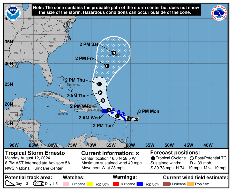
Information from the latest update explained that the system will likely continue to slowly intensify and is still forecast to impact the USVI and Puerto Rico starting Tuesday evening.
“Maximum sustained winds are near 40 mph (65 km/h) with higher gusts,” the NHC update said. “Gradual strengthening is expected during the next few days,” the update continued.
USVI residents and visitors can find information regarding hurricane preparedness from the Virgin Islands Territorial Emergency Management Agency and the National Oceanic and Atmospheric Administration.
Source Weather Page also publishes a daily weather forecast and offers readers the opportunity to view weather forecast videos and disaster preparedness video segments.