
A new public engagement website is inviting residents and visitors to weigh in on the future of parks, trails, beaches, sports fields, and other outdoor recreation spaces across the U.S. Virgin Islands, as officials prepare a plan to guide improvements over the next decade.
The website is part of the 2026-2036 U.S. Virgin Islands Territorial Comprehensive Outdoor Recreation Plan (TCORP), a federally required plan that will help guide outdoor recreation and conservation priorities across St. Croix, St. Thomas and St. John.
New Website Launches for Public Input
The public engagement site was launched by the Horsley Witten Group (HWG), an environmental consulting firm working with the Virgin Islands Department of Planning and Natural Resources (DPNR) and its Division of Territorial Parks and Protected Areas.
The site gives the public two ways to provide feedback: a public opinion survey and an interactive mapping tool.
“The online platform marks a key step in the public engagement process for the TCORP, providing tools for island residents and visitors to share how they use outdoor recreation and conservation areas,” according to a press release from HWG. “It features two separate surveys: a traditional public opinion survey for feedback on recreation habits, preferred amenities, and access to parks, trails, and waterfront spaces, and an interactive “Survey123” web map for location-specific input,” HWG said.
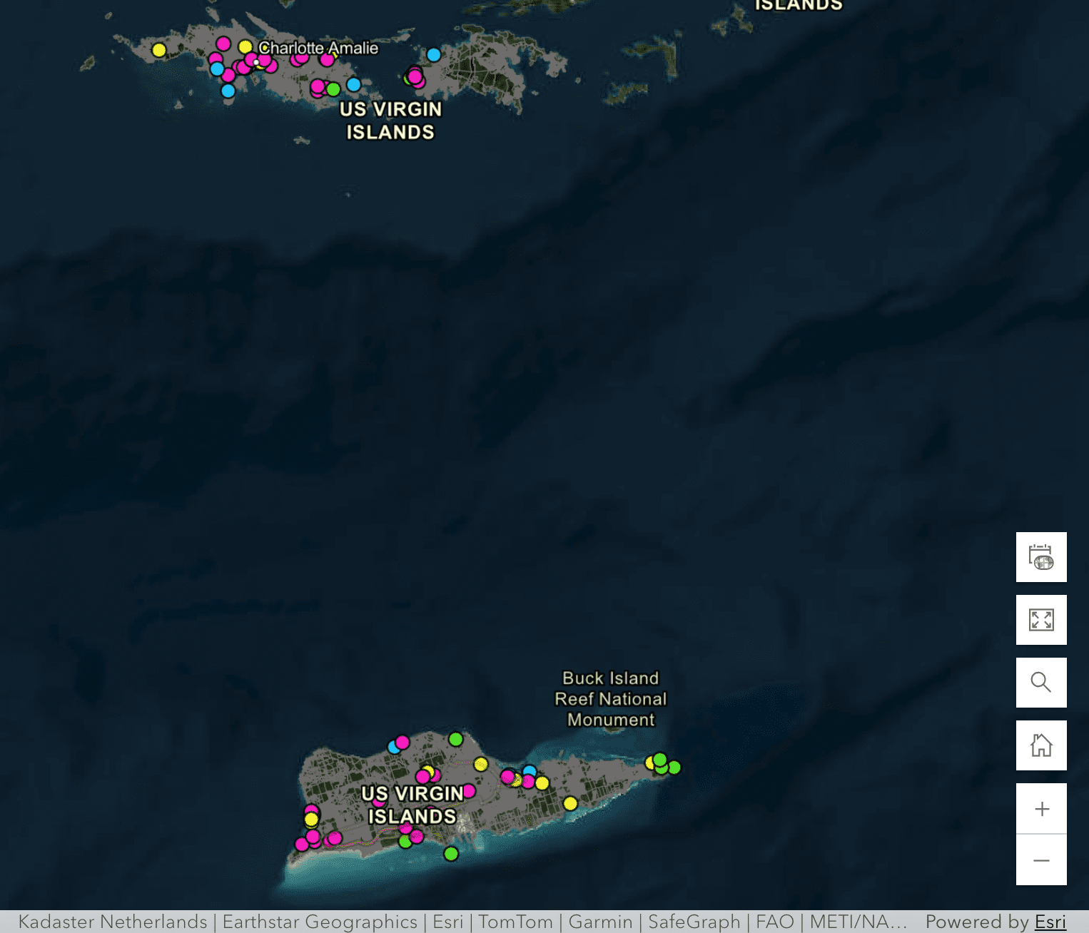
“The interactive map allows users to drop pins directly on a digital map of the U.S. Virgin Islands and leave comments tied to specific sites. Participants can highlight areas needing improvement or suggest new recreational amenities, offering a detailed and geographically specific form of public input.”
The Source contacted Craig Pereira, senior planner/project manager with the Horsley Witten Group, for additional details about the project. Pereira explained that his role includes coordinating with Kristina “Kitty” Edwards, director of Territorial Parks and Protected Areas as the project moves through inventory work, site assessments, and public engagement.
Pereira said the team has been developing an inventory of recreation sites that will be reviewed as part of the planning process. The work will include on-island site assessments, meetings with stakeholders, consultations with a technical advisory committee, and public workshops across the territory.
“Currently we’re working on developing our itinerary and schedule for those on-island site assessments as well as the public meetings across the three main islands of the USVI,” Pereira said.
Interactive Map
The “Survey123” mapping tool allows users to drop a pin on an existing or proposed recreation location and provide input tied to that specific place. The website also allows users to view a map inventory of outdoor recreation facilities in the territory, click on map points for more information, and upload photos for the project team to review.
“This phase of the project is about making it easy for residents and visitors to provide meaningful feedback on the territory’s outdoor recreation resources,” Pereira said in the press release announcing the website launch. “The interactive map, in particular, allows users to connect their input directly to specific parks, trails, sports fields, and waterfronts, helping ensure future investments will reflect how these spaces are actually used.”
Pereira told the Source that the interactive map gives the public a way to comment on existing sites, identify concerns, and point out locations that may not yet be formally recognized as recreation assets.
Through the mapping tool, users can also identify lesser-known outdoor spaces that they believe should be considered in the planning process.
Public Survey Looks at How Recreation Areas Are Used
The website also includes a separate Public Opinion Survey, which asks broader questions about how people use outdoor recreation facilities and open spaces in the territory.
“We want to know what individuals across the territory are happy with and what activities they are not happy with. For example, are people satisfied with amenities that are provided at a park, and are there issues like safety or security measures or better access to a park that would improve the use and enjoyment of an outdoor recreation facility? When we understand the needs of the public, we can start to develop a list of what’s working and what could be improved upon,” Pereira said.
The online survey is open to residents and visitors. Pereira said the project team is seeking input from anyone who uses outdoor recreation facilities and open spaces in the territory.
Edwards said in the press release that the surveys will help the project team better understand how outdoor recreation areas are currently used and where improvements may be needed.
“We are excited to have the public engagement phase of this project kicked off! The Public Opinion Survey will serve to better understand how residents and tourists utilize outdoor recreation – where they visit, what are the preferred amenities, and how they typically access parks, trails, and waterfront areas,” Edwards stated. “The Survey 123 web map will provide site-specific information regarding favorite destinations or the identification of areas that may be underserved and in need of outdoor recreational facilities.”
Public participation will continue beyond the online tools, with outreach efforts expected to include on-island meetings and coordination with local organizations.
Pereira said the project team will post information about upcoming workshops and meetings once the schedule is finalized.
“Once our on-island itinerary is confirmed, we’ll be posting our workshops and meetings, including when we’re going to be on island and where, so we want to make sure people are well aware of that in advance,” Pereira said.
Plan Will Guide Future Recreation Funding
The public input gathered through the website will help inform a plan that carries both local and federal importance for the territory’s outdoor recreation future, according to the HWG press release.
“The TCORP is a federally required plan that allows the U.S. Virgin Islands to remain eligible for Land and Water Conservation Fund support, administered by the National Park Service,” the HWG reported. “More than $2 million is expected to fund improvements to parks, recreational facilities, and public access across the territory, with the plan guiding how these funds are prioritized and invested over the next decade in coordination with DPNR and its Division of Territorial Parks and Protected Areas. The TCORP is expected to be completed by early 2027.”
Residents and visitors can access the project website, public opinion survey, and interactive maps at https://www.usvioutdoors.com/.