3:07 a.m. Sept. 3
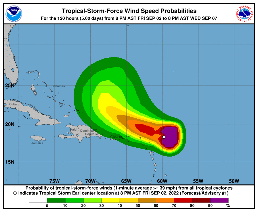
Invest 91L has become Tropical Storm Earl and is forecast to pass near or just to the north of the U.S. Virgin Islands and Puerto Rico over the Labor Day weekend.
Earl, the fifth named storm of the Atlantic hurricane season, is expected to bring gusty winds, especially in squalls, to the area on Saturday and Sunday after forming late Friday just east of the Northern Leeward Islands, according to the National Hurricane Center.
Additionally, heavy rainfall from Earl is expected to lead to “limited flash, urban and small stream flooding over the Leeward Islands, U.S. and British Virgin Islands and Puerto Rico this weekend,” the center said in an update issued late Friday.
Earl was moving west-northwest at 14 mph with sustained winds of 40 mph and is forecast to take a northerly turn on Monday.
7:14 p.m. Sept. 2
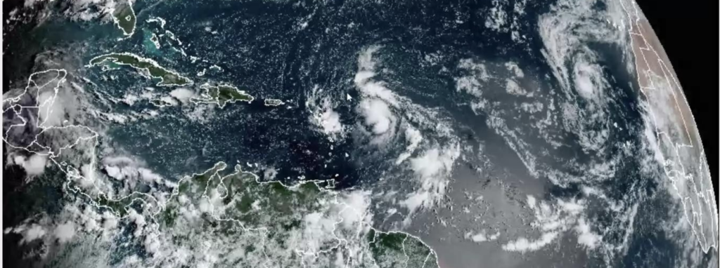
Invest 91L could become a tropical depression as early as Friday night, the National Hurricane Center said Friday evening in an update on the system that is passing northeast of the U.S. Virgin Islands.
The update comes after hurricane hunters explored the tropical disturbance Friday afternoon.
“Data from an Air Force Reserve Hurricane Hunter aircraft indicate that the circulation associated with an area of low pressure located a couple of hundred miles east of the Leeward Islands has become better defined today, and the plane reported that surface pressures have fallen a bit,” the NHS said.
“If the showers and thunderstorms associated with the low persist through the evening, the system could become a tropical depression as early as tonight,” the service said.
The bulk of the storm is expected to pass well northeast of the USVI, forecasters with the National Weather Service in San Juan, Puerto Rico, said during a webinar press briefing on Friday morning. They will provide an update on Saturday morning.
12:32 p.m. Sept. 2
The U.S. Virgin Islands is “highly likely” to see activity starting Friday night from Invest 91L, the tropical disturbance that is forecast to pass northeast of the territory through the Labor Day weekend, according to meteorologists with the National Weather Service in San Juan, Puerto Rico.
The area of potential impact was adjusted slightly south on Friday to encompass the USVI, though forecasters are still predicting the main effects from Invest 91L will be from rain and thunderstorms, said meteorologist Ian Colon-Pagan. Rainfall accumulations of 1 to 1 ½ inches are possible in the USVI, and 2 to 2 ½ inches in Puerto Rico, he said.
“We’re actually not expecting strong winds from this system – they should remain light to moderate – but shifting from the northeast to southeast within the next few days as the system moves northeast of the local islands. Nonetheless, gusty conditions are likely, especially in the vicinity of the thunderstorms, with wind gusts that could reach the 30 to 40 miles per hour range,” said Colon-Pagan.
Regardless of the wind, “we are still expecting some impact, potential hazards from this system,” he said.
People should stay alert for possible flash flooding and mudslides, as well as lightning, said Colon-Pagan, speaking at a webinar held Friday morning to update government officials, including from the V.I. Territorial Emergency Management Agency, and the media on Invest 91L.
Ernesto Morales, warning coordination meteorologist in the NWS San Juan office, said the USVI is “highly likely” to experience storm conditions Friday night, followed by a slight break in the disturbance, and then more rain and thunderstorms later Saturday and Sunday night.
The disturbance also is forecast to create hazardous marine conditions, especially around areas of thunderstorms, with seas of 7 to 9 feet, said Colon-Pagan. For that reason, a small craft advisory is in effect for the offshore Atlantic waters, he said.
While the rip current risk remains low for Friday, it will change to life-threatening over the weekend and is forecast to remain high in the aftermath of the storm, especially for the north- and east-facing beaches of the islands, he said.
Officials with the San Juan weather office will be monitoring Invest 91L through the weekend and will issue updates should it shift to a more westward track, bringing it closer to the islands, said Morales.
Morales urged people to stay alert and to follow official sources such as the National Weather Service and VITEMA for information. The Source also will post updates as necessary.
“We’re expecting weather from Invest 91L to affect us for the next 72 hours. There is a segment that we’re going to get some rain, and then there is a break in the middle, and then more moisture is going to move across the region through Monday. I know this is a big weekend for a lot of you. It’s Labor Day weekend, there’s a lot of people on the beach, on the rivers, therefore we need to be aware of any changes associated to the forecast of this system,” said Morales.
“Don’t trust accounts in Facebook or something that is not an official source of weather information,” Morales stressed. “Please just follow us here at the National Weather Service. We are experts working for you and for all the citizens in the islands.”