We are all familiar with the U.S. hotbeds of earthquake activity – California, for example. But what about the U.S. Caribbean territories?
The U.S. Virgin Islands and Puerto Rico are regularly rattled by earthquakes, and the region overall is seismically active. The Puerto Rico Seismic Network (PRSN), which also operates under its Spanish name, Red Sísmica de Puerto Rico, is based in the city of Mayagüez on the west coast of Puerto Rico. The organization is constantly watching over the territories to help keep Virgin Islanders safe and informed about earthquakes and potential tsunami waves.
The Source spoke with Elizabeth Vanacore, a seismologist and a researcher at the organization. Vanacore shared details about the work that PRSN conducts, and she provided information about earthquakes in the Caribbean, including what people can do to be prepared in the event of a quake.
Responsibilities of the Puerto Rico Seismic Network
The major responsibilities of PRSN involve the research and monitoring of the local area for shaking by utilizing a network of tools and instruments, providing education about earthquakes, and collaborating with various agencies to keep the public safe and informed.
“The Puerto Rico Seismic Network is a part of the University of Puerto Rico Mayagüez Department of Geology,” Vanacore explained. “The PRSN operates seismic, GPS, and sea level monitoring instruments across the region and is responsible for monitoring and disseminating information about earthquakes within our Area of Responsibility (AOR). [This region] ranges from the eastern Dominican Republic to the Virgin Islands,” she said.
“At an international level, PRSN is an active participant in the Intergovernmental Coordination Group for the Tsunami and other Coastal Hazards Warning System for the Caribbean and Adjacent Regions of UNESCO working with the wider Caribbean community toward more earthquake and tsunami resiliency,” Vanacore continued.
“The PRSN and our sibling network, Puerto Rico Strong Motion Program (PRSMP), operate seismic [instruments called] broadbands and accelerometers in the Virgin Islands,” noted Vanacore. “The broadband will detect the large magnitude events from the other side of the world, while the accelerometer is not sensitive enough to sense events at such distances. The accelerometers really are most useful for local large-magnitude events,” she added.
Data obtained from accelerometers include measurements of “peak ground acceleration” that occur during an earthquake. This information is ultimately displayed on widely accessed maps, including earthquake Shakemap, a website that displays global earthquake data in real-time from around the world and is operated by the United States Geological Survey (USGS). PRSN and PRSMP also create Shakemaps and Shakecasts, which are published on the websites of the organizations.
In addition to monitoring quakes, PRSN collaborates with emergency management agencies and organizations to ensure that the public is informed about any dangers related to a seismic event.
“There are over 200 real-time seismic stations streaming into the PRSN, as well as sea level data from across the Caribbean,” Vanacore stated. “In the case of a significant event (a magnitude 3.5 on the earthquake magnitude scale or greater), the PRSN will send out initial information within five minutes of the earthquake. The priority is to [share the data with] emergency management agencies across Puerto Rico and the USVI, but this information is also published with a web banner at the top of our webpage and on social media. The earthquake is then reviewed by a duty analyst and updated with the final information [and then published on sites including the USGS],” Vanacore explained.
Earthquakes in the Caribbean
Islands in the northeast Caribbean are situated where temblors frequently strike due to their location among tectonic plates and fault systems, as was reported in another Source article regarding Caribbean earthquakes.
“The tectonic plates divide the Earth’s crust into distinct ‘plates’ that are always slowly moving. Earthquakes are concentrated along these plate boundaries,” according to the USGS.
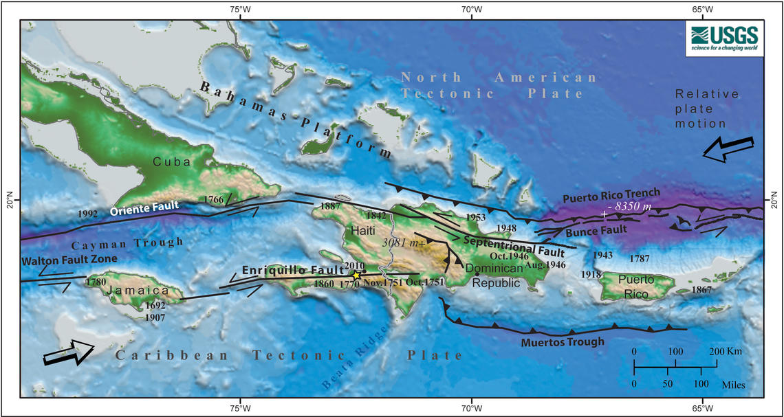
“The seismicity of this region of the Caribbean is dominated by the oblique subduction of the North American Plate beneath the Caribbean Plate,” said Vanacore. “The term oblique subduction indicates that the collision between the North American tectonic plate and the Caribbean tectonic plate is not occurring in a direct head-on manner, but instead, at an angle,” according to Vanacore.
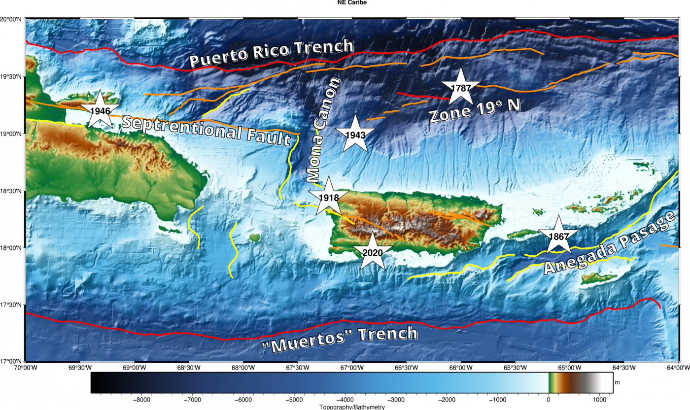
“This plate collision is the force that has created the Puerto Rico Trench, as well as the faults to the west of Puerto Rico in the Mona Passage. [The collision of the plates has also created faults] in the Anegada Passage and the Muertos Trough,” Vanacore explained.
The result of the tectonic plates colliding means that the USVI and Puerto Rico are in an area surrounded by faults, and earthquakes occur in this region on a daily basis.
“This plate collision leads to the very complicated faults systems and interactions with our region,” Vanacore said. “Given this environment, Puerto Rico and the USVI are in a seismically active region where earthquakes are recorded and reported by the PRSN on a daily basis. The PRSN records a few thousand earthquakes a year in our AOR,” she continued.
Potential for Quakes and Tsunami Waves in the USVI
With the U.S. Virgin Islands situated in such an active seismic zone, it behooves residents to understand the potential for a major earthquake or tsunami striking the territory, which has occurred in the past.
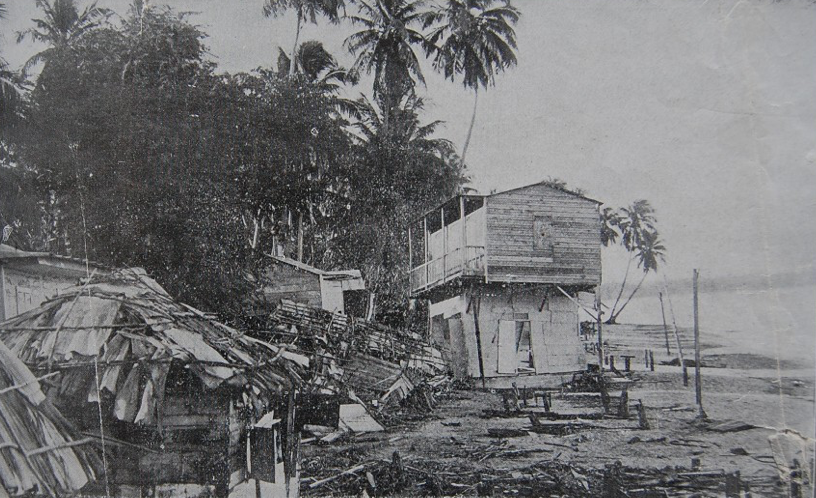
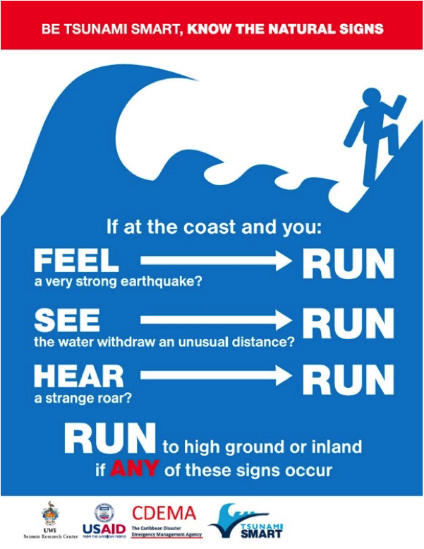
Tsunami waves are defined by the National Weather Service as “a series of waves that can cause dangerous fluctuations of water along shorelines and are generated by earthquakes, volcanic eruptions, or landslides that cause a large scale and rapid displacement of the water.” Vanacore cited a powerful quake in 1867, which shook the USVI and caused a tsunami.
“The most significant earthquake in recent history for the Virgin Islands is the 1867 Anegada Passage earthquake and tsunami. This stemmed from a magnitude 7.3 earthquake roughly 20 km southwest of St. Thomas,” Vanacore said. “[The temblor] generated a tsunami with a maximum height of approximately 15 meters. However, even earthquakes from a distant location can generate tsunamis impacting the Caribbean,” Vanacore added.
When asked about the probability of a quake of this scale happening again, Vanacore stated, “I prefer not to talk about chances or probabilities. Unlike hurricanes, earthquakes don’t give days of warning. The key for the public is to understand that the risk is there, and we should all be prepared for earthquakes and tsunamis in our region,” she warned.
Vanacore stressed the importance for the public to recognize that quakes happen across the region on a daily basis. Small quakes can occur, which are too minor even to be noticed by individuals across the territory.
“It is important to note first that one cannot predict earthquakes,” Vanacore emphasized. “However, we do know based on historical records that significant earthquakes and tsunamis like the 1918 Puerto Rico event and the 1867 Anegada earthquake and tsunami have occurred in the past,” she continued.
“The next damaging earthquake/tsunami could occur tomorrow, or it could occur 100 years from now, but the risk of such an event is always present, [and] across the northeastern Caribbean there is potential for significant earthquakes on any of our major faults,” said Vanacore. “The key is mitigation and preparing for such an event before it happens. Both the PRSN and Virgin Islands Territorial Emergency Management Agencies (U.S. and British) have resources available to assist in preparing for this hazard,” she explained.
Community Preparedness
Vanacore explained that community preparedness can help with managing the effects of an earthquake or a tsunami, as well as aid in establishing an effective response in the aftermath of a disaster.
“Vulnerability is not only a factor of the earthquake magnitude and location but also on community preparedness and ability to recover after such an event,” declared Vanacore. “The impact of the earthquake and tsunami when it happens will depend greatly on mitigation and preparedness efforts undertaken today. Homes and businesses that are built on stilts and/or have not been reinforced to meet the current earthquake codes will be more vulnerable to shaking damage,” she continued.
“Communities on the coast need to be aware if they need to evacuate in case of a tsunami warning; maps are available from local emergency management. Do local businesses, schools, and households include earthquakes and tsunamis in their emergency plans? If not, these are steps that can be taken today to lessen the impact of future earthquakes,” Vanacore advised.
Staying Informed
In addition to the research that PRSN conducts, the group is also involved in community outreach and education. For example, every October, individuals can participate in a ShakeOut exercise, a practice for what to do during a strong earthquake.
“ShakeOut is the annual earthquake exercise in October where everyone is encouraged to practice the Drop, Cover, and Hold On [recommendation] and review earthquake safety and preparedness,” Vanacore said.

“In March, there is the CARIBE WAVE exercise, which is an international event for the entire Caribbean and adjacent regions,” Vanacore stated. “The exercise involves the development of a scenario, a communications test between the Pacific Tsunami Warning Center and the tsunami warning points on the island, as well as education and outreach about tsunami safety and in some communities a full tsunami walk.”
Vanacore encouraged residents across both Puerto Rico and the Virgin Islands to learn more about earthquakes and tsunamis to be as prepared as possible.
Information about earthquake and tsunami safety is available from the PRSN in both English and Spanish, and more details are available on the organization’s website.
Weather information is also updated regularly on the Source Weather Page and the Source YouTube Channel. USVI residents and visitors can also sign up for emergency alerts from the Virgin Islands Territorial Emergency Management Agency and the National Weather Service.