The Atlantic hurricane season began on June 1, and the Atlantic basin remains quiet, while the Eastern Pacific is already active. However, forecasters are closely watching part of the Gulf for possible tropical development later this month, although dry air and wind shear continue to limit most tropical activity.
First Tropical Outlook of the Season
This is the first Virgin Islands Source Tropical Outlook of the 2026 Atlantic hurricane season. The outlook is part of a semi-regular Source weather update intended to keep readers informed about tropical activity across the Atlantic basin, the Caribbean, and nearby regions during hurricane season.
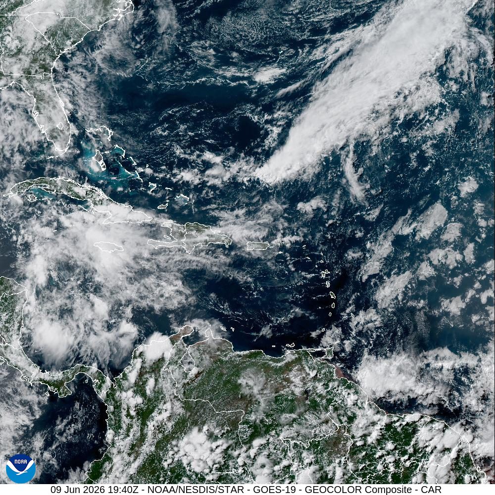
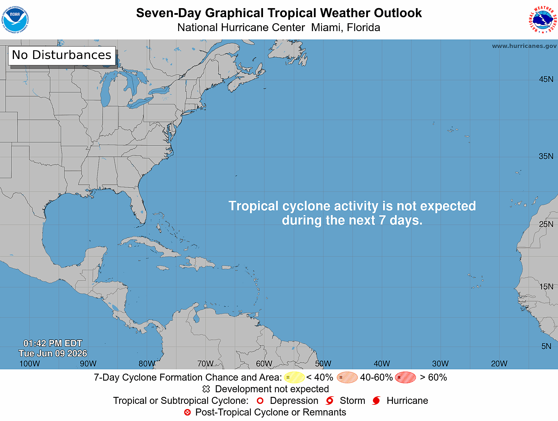
As of Tuesday, the National Hurricane Center said tropical cyclone formation is not expected across the North Atlantic, Caribbean Sea, or Gulf during the next seven days. However, the NHC’s Tropical Weather Discussion noted several tropical waves moving westward across the Atlantic and Caribbean, although none of those waves is expected to develop into a tropical system at this time.
Low Chance of Development in the Gulf Later in June
While the Atlantic remains quiet overall, the Gulf will be one area to monitor in the coming days.
“A trough or weak low-pressure center may emerge from the Yucatán Peninsula into the Bay of Campeche, on Thursday through Friday night accompanied by numerous showers and thunderstorms, along with fresh to strong winds and building seas,” according to the NHC.
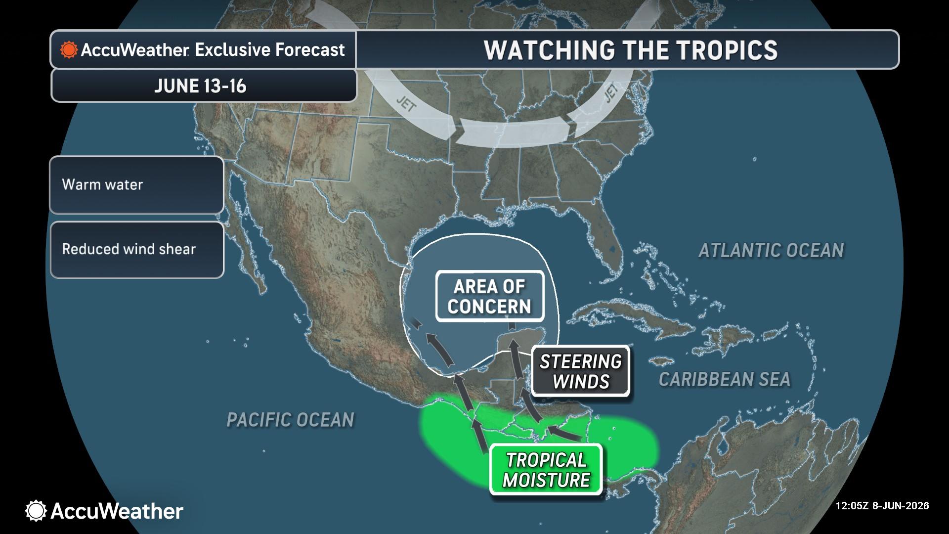
Alex DaSilva, lead hurricane expert at AccuWeather, told the Source that the Gulf will be one area to watch, although any development chances remain low.
“We are currently watching the Gulf for possible development toward the middle of the month,” DaSilva said. “Some moisture may come over from a tropical rainstorm that we are tracking in the Pacific. Any development chances are low, but we need to watch this area closely. After that, there doesn’t look to be anything in the near term. Most of the tropical waves this year have been choked out by dry air and wind shear,” he continued.
Eastern Pacific Already Active
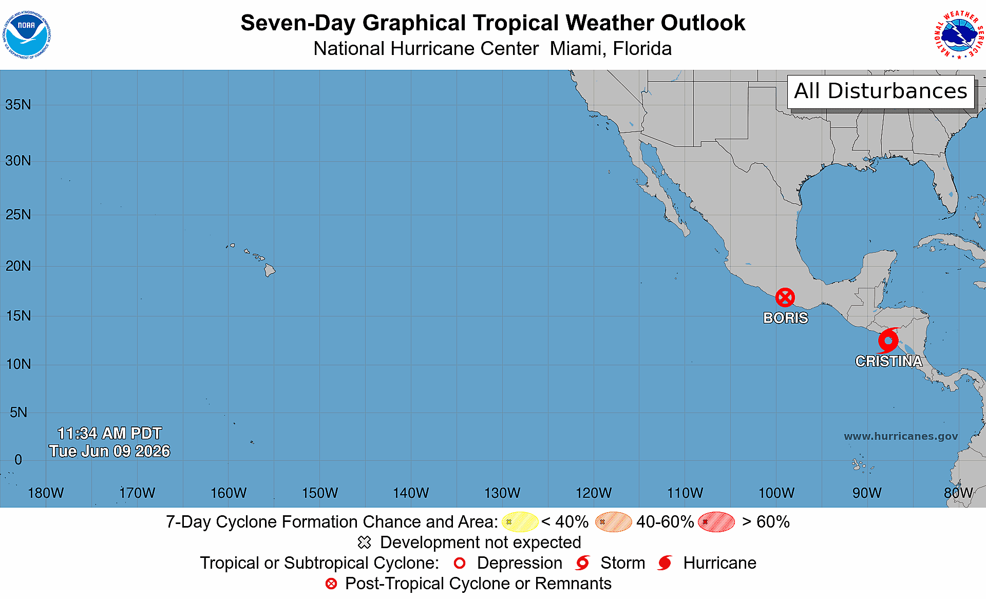
The Eastern Pacific basin, meanwhile, has been active, with three named systems having developed already. Tropical Storm Amanda developed earlier in June. As of Tuesday, the NHC was issuing advisories on Post-Tropical Cyclone Boris, located just inland over southern Mexico and Tropical Storm Cristina, located near the northwestern coast of Nicaragua. No additional tropical cyclone formation is expected in the Eastern Pacific during the next seven days.
DaSilva said the early activity is not unexpected, although the basin is running ahead of schedule climatologically.
“The average second-named storm in the Eastern Pacific is June 24, so we are ahead of schedule. This is not surprising as we have been forecasting an active Pacific season with early season development. Sometimes, if there are a lot of storms in the Eastern Pacific, it can help to increase wind shear in the Atlantic,” DaSilva noted.
Although additional tropical activity is not expected in the Eastern Pacific during the next seven days, there are signs that the basin will continue to produce storms.
According to the latest Global Tropics Hazards Outlook from the Climate Prediction Center, a weekly report released every Tuesday by the National Oceanic and Atmospheric Administration, the Pacific will have elevated chances of tropical development during the middle to latter half of June. The Atlantic basin is anticipated to stay quiet.
The longer-range forecast also indicated that Puerto Rico and the U.S. Virgin Islands could see drought conditions persist or worsen.
A Potentially Below-Average Atlantic Hurricane Season
As the Source previously reported, the NOAA expects a below-normal season in the Atlantic, due in large part to El Niño, which involves a warming of the equatorial Pacific Ocean. El Niño usually helps to increase wind shear – a change in wind direction and velocity with height in the atmosphere – in the Atlantic Ocean.
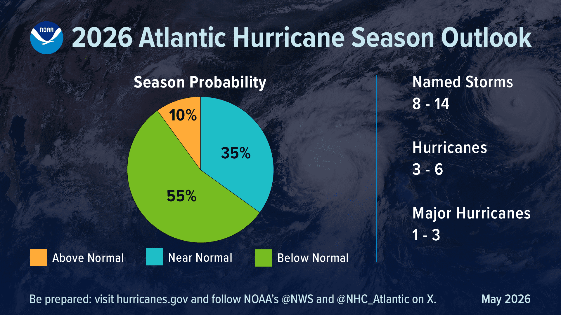
The increase in wind shear from El Niño helps to disrupt storms and prevent hurricane formation and intensification. This is the opposite of a La Niña cycle, when the ocean waters across the equatorial Pacific cool significantly. During La Niña, wind shear typically decreases in the Atlantic, and a reduction in wind shear can favor cyclone development.
Nevertheless, while El Niño can help to increase wind shear in the Atlantic basin, it tends to decrease across the Eastern and Central Pacific basins, typically helping to create conditions that are more conducive to cyclonic development.
Importantly, wind shear is only one component of hurricane development, and residents and visitors should remain prepared across the Atlantic and Caribbean despite the possibility of a below-average season. It only takes one storm to cause massive devastation.
Local Weather: Heat, Dust and Some Rain Chances
Across Puerto Rico and the U.S. Virgin Islands, the main local concerns this week include dangerous heat, traces of Saharan dust, and a possible increase in shower and thunderstorm activity later in the week, as well as gusty winds. The National Weather Service in San Juan, Puerto Rico, explained the local conditions in its Area Forecast Discussion on Tuesday.
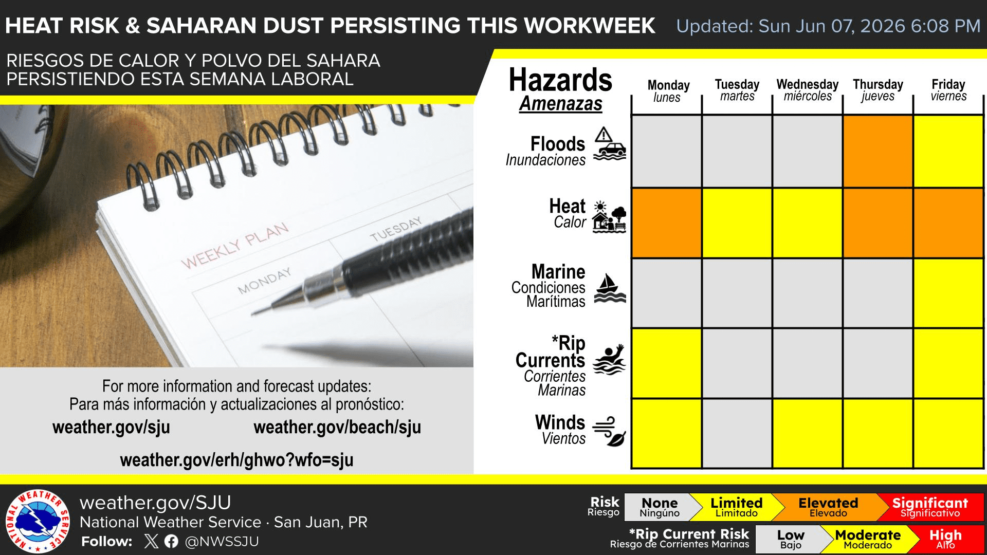
“Dangerous heat will continue through at least midweek,” the NWS said. “Heat indexes will exceed 100°F, especially across urban, coastal, and lower-elevation areas of Puerto Rico and the U.S. Virgin Islands.”
The NWS issued heat advisories across the region on Monday and Tuesday, and additional alerts may be issued later in the week. Residents and visitors across both U.S. territories are encouraged to stay as cool as possible to avoid heat-related illnesses.
“A wetter and more unstable weather pattern is expected on Wednesday and especially Thursday, as a tropical wave interacts with an approaching upper-level trough, increasing the coverage of showers and thunderstorms across the region. The greatest risk of flooding will occur on Thursday,” the NWS stated.
The NWS also noted that minor concentrations of Saharan dust will be prevalent in the atmosphere, causing a hazy sky.
Finally, marine conditions around the islands are expected to remain somewhat choppy at times, and a moderate risk of rip currents is forecast from Thursday through early next week, particularly along east- and north-facing beaches in Puerto Rico and the U.S. Virgin Islands.
Forecast Updates
Information regarding the weather across the USVI, including marine forecasts, is available from the NWS and NOAA. The latest tropical forecasts can be viewed on the official website of the NHC.
The local forecast is regularly updated on the Source Weather Page, and a weekly video forecast is available. Additionally, residents and visitors can view weather alerts and disaster preparedness information from the Virgin Islands Territorial Emergency Management Agency