Tropical Storm Erin is forecast to pass near the U.S. Virgin Islands and Puerto Rico this weekend, but the National Hurricane Center says it is still too early to know what impacts the storm might bring. Forecasters advise residents to keep a close watch.
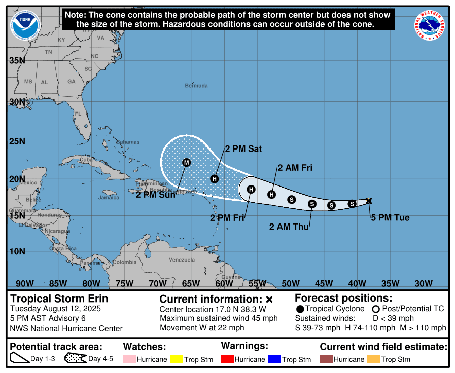
As of the 5 p.m. Tuesday update from the NHC, Erin was about 950 miles west of the Cabo Verde Islands off the west coast of Africa, moving quickly west with maximum sustained winds near 45 mph.
“At 5:00 PM AST, the center of Tropical Storm Erin was located near latitude 17.0 North, longitude 38.3 West,” the NHC reported. “Erin is moving toward the west near 22 mph, and a slightly slower westward motion is expected tonight through Thursday, with a west-northwestward motion beginning Thursday night and continuing into the weekend. On the forecast track, the center of Erin is likely to move near or just north of the northern Leeward Islands over the weekend,” the NHC said.
Indeed, as of Tuesday evening, the official NHC track takes the cyclone north of the USVI and Puerto Rico, and no alerts have been issued. Notably, while Erin’s forecast track edged slightly closer to the local islands in Tuesday morning’s update, the 5 p.m. advisory showed no further shift toward the islands.
“The new 5 p.m. NHC track forecast has no appreciable difference from the morning forecast, with no additional shifting toward the northern Leeward Islands,” the NHC said. “Keep in mind that NHC track forecasts have an average error of 120-180 nautical miles at days four and five in the future, and additional adjustments in the forecast are still possible,” the NHC added.
The Track of Tropical Storm Erin
Erin is expected to maintain a path slightly south of due west through Wednesday, steered by strong high pressure over the Atlantic. By Thursday night, a gradual turn toward the west-northwest is possible as the ridge of high pressure weakens, a track that would take the cyclone northeast of the local islands. However, there is still uncertainty about when that turn will occur, and future forecast adjustments are possible.

While the core of the cyclone may pass north of the U.S. Virgin Islands and Puerto Rico, the NHC said Tuesday that it is still too early to determine whether there could be any direct impacts across the local islands.
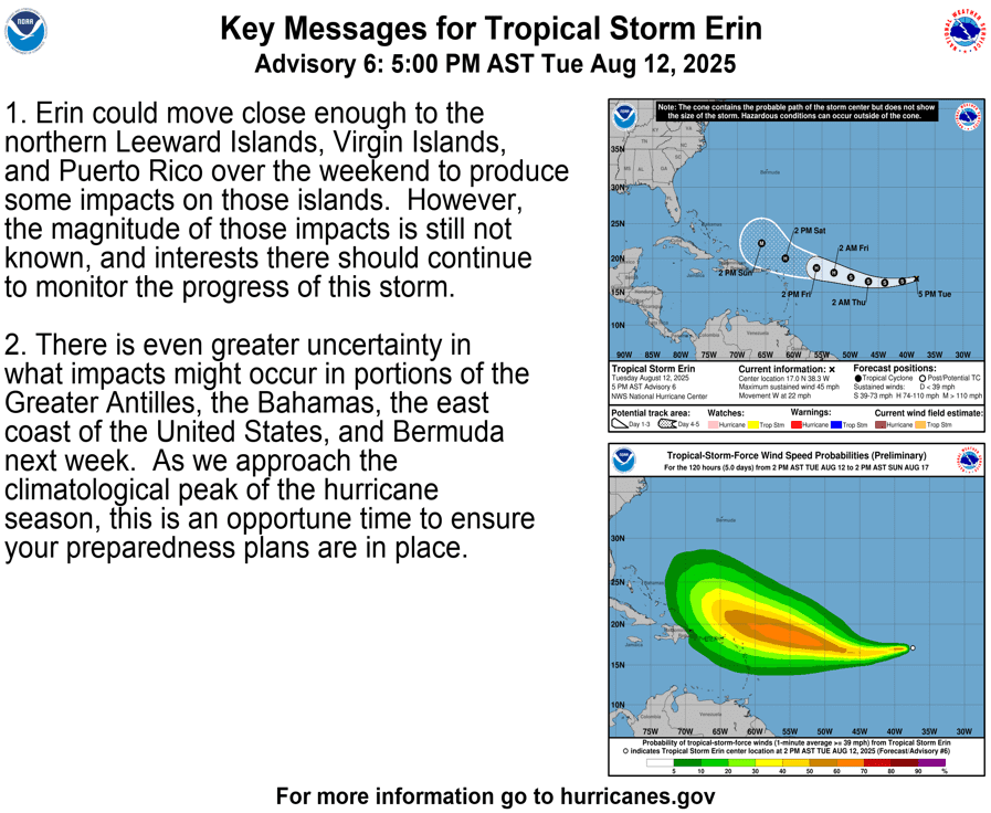
“Erin could move close enough to the northern Leeward Islands, Virgin Islands, and Puerto Rico over the weekend to produce some impacts on those islands,” according to an update from the NHC Tuesday. “However, the magnitude of those impacts is still not known, and interests there should continue to monitor the progress of this storm.”
“There is even greater uncertainty in what impacts might occur in portions of the Greater Antilles, the Bahamas, the east coast of the United States, and Bermuda next week,” the NHC acknowledged. “As we approach the climatological peak of the hurricane season, this is the opportune time to ensure your preparedness plans are in place,” the NHC added.
Erin Expected to Strengthen Soon
As was reported in a Source article published Monday, forecasters say the storm will likely strengthen slowly at first due to cooler waters and dry air, but could intensify more quickly as environmental conditions improve. The system is eventually anticipated to intensify into a hurricane, with maximum sustained winds of at least 74 mph or higher.
The Source reached out to Alex DaSilva, lead hurricane specialist at AccuWeather, to obtain more information about Tropical Storm Erin and the potential threat to the USVI and Puerto Rico. DaSilva noted that, while the cyclone has been traveling through cooler water temperatures and dry air on Tuesday, it will soon move into an environment that is more conducive for potential intensification.
“Erin has been really struggling from dry air and also the cooler sea surface temperatures on Tuesday,” DaSilva said. “From this point forward, the water temperatures are going to be getting warmer as Erin advances through the weekend. Disruptive wind shear is not a factor for this storm right now, and therefore, Erin is forecast to intensify on Wednesday,” DaSilva noted. “The process may be slow because it’s going to be dealing with some of that dry air, but the waters will be warmer.”
Erin’s Updated Forecast Track
DaSilva explained the reasons for the slight adjustment of Erin’s track on Tuesday morning, possibly bringing the disturbance closer to the USVI.
“Weaker storms tend to travel further west,” DaSilva said. “Stronger storms tend to be driven more by the upper levels of the atmosphere, which will tend to turn the storm to the north. When a storm is weaker, it just tends to move more with the trade winds, which are usually from east to west. This is a factor that we’re going to have to monitor very closely. This is likely part of the reason why we’re seeing a westward shift in some of the model guidance. Erin is currently a bit on the weaker side and it’s getting pushed more by the trade winds,” DaSilva continued.
“If Erin remains weak and is unable to gain intensity, there is a chance that it may track closer to the islands. If this storm strengthens, as it is expected to, it should start to pull to the north.”
DaSilva went on to explain some of the possible effects that the local region could receive due to Erin, primarily between Saturday and Monday.
“Because Erin could track a bit closer to the Virgin Islands, AccuWeather is now forecasting one to two inches of rainfall for the U.S. and British Virgin Islands,” DaSilva confirmed. “We expect some 40 to 60 mph wind gusts at times in some of the northern portions of the islands,” DaSilva said.
“However, at this time, the core of the storm is forecast to track north of the islands,” DaSilva reported. “Still, we are concerned about rain bands on the outside of the storm, which are common with many tropical cyclones and hurricanes. They can be fairly slow-moving at times, and some areas could see localized rainfall totals of three to five inches, with locally higher amount up to seven inches across the northeastern Caribbean.”
“Everyone on the islands should remain on guard and be prepared for the weather to deteriorate on Saturday. Rip currents and rough surf are a serious concern for boaters and at the beaches,” DaSilva advised.
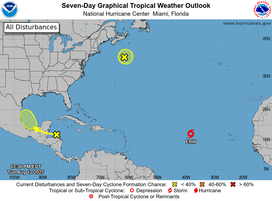
In addition to Tropical Storm Erin, the National Hurricane Center is monitoring a disturbance in the northwestern Atlantic and a cluster of showers and thunderstorms near the Gulf, both with a low chance of development.
Local Weather Information
On Tuesday, the National Weather Service in San Juan, Puerto Rico, said that while direct impacts remain uncertain, Erin could still produce indirect effects even if it passes north of the islands, including choppy seas of 8 to 12 feet and a high risk of rip currents.
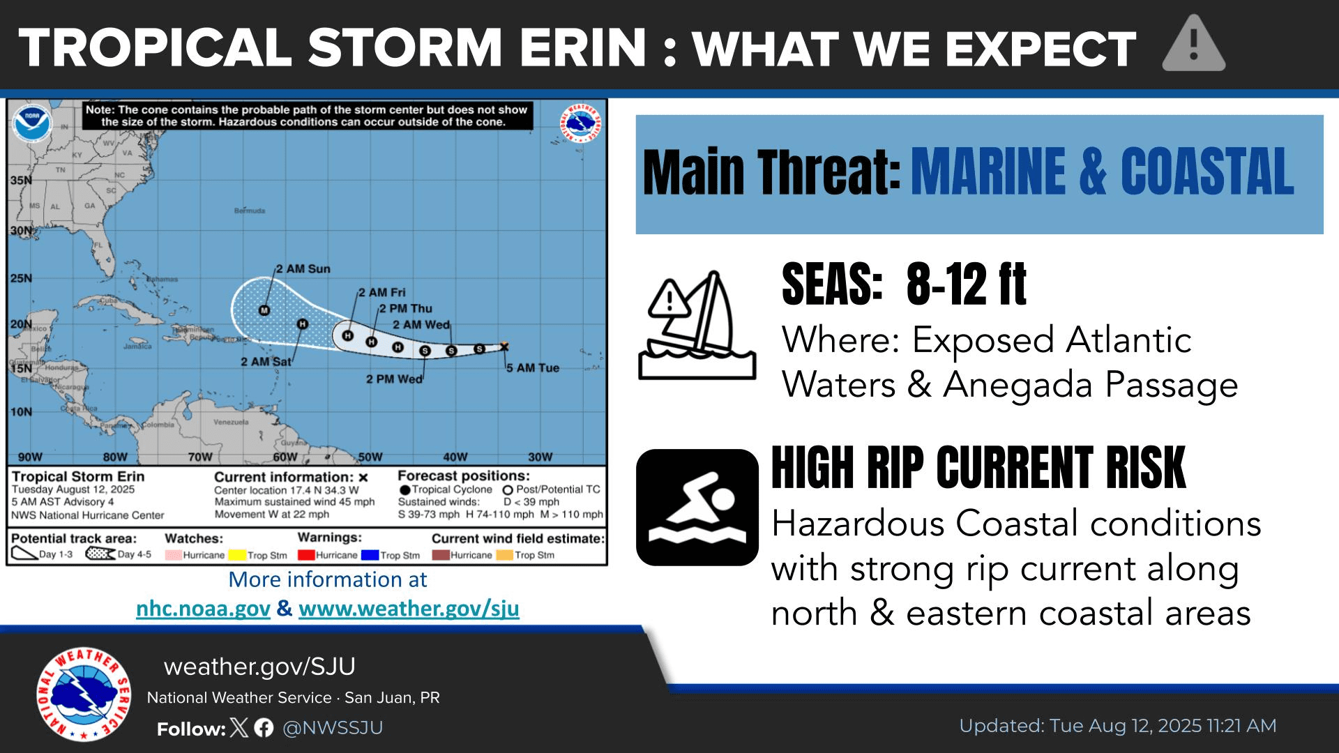
“By the weekend, the forecast depends on the future of Tropical Storm Erin,” the NWS said. “It is currently forecast to move northeast of the region, but it could trigger marine hazards. Stay informed and monitor future forecasts,” the NWS said.
In addition to any impacts that may occur from Tropical Storm Erin this weekend, warm temperatures are expected to persist, with the possibility of heat alerts. Saharan dust is forecast to be prevalent in the atmosphere through early Thursday, causing hazy conditions through midweek. Showers and thunderstorms are also possible throughout the week.
It is crucial to remember that the forecast can change very quickly. USVI residents and visitors are encouraged to continue to remain prepared. Weather information is available from the NWS, the NHC, and NOAA.
Additionally, the local weather forecast for the U.S. Virgin Islands is regularly updated on the Source Weather Page and VI Source YouTube Channel. A weekly Tropical Outlook article from the Source is also published throughout hurricane season to provide in-depth updates.
Residents and visitors can find additional weather alerts and preparedness information from the Virgin Islands Territorial Emergency Management Agency.